
National Register of Historic Places listings in Montgomery County, Missouri facts for kids

Welcome to Montgomery County, Missouri! This page tells you about special places here that are listed on the National Register of Historic Places. Think of it like a national scrapbook of important buildings, sites, and objects that tell us about America's past.
These places are chosen because they are important to history, architecture, archaeology, engineering, or culture. When a place is on the National Register, it means it's recognized as a valuable part of our heritage. In Montgomery County, there are 9 such places, and one of them is even a National Historic Landmark, which is an even higher level of importance!
Exploring Montgomery County's Historic Gems
Montgomery County has many interesting spots that have been saved because of their history. Let's take a look at some of these cool places.
Historic Homes and Buildings
Many old buildings in Montgomery County have stories to tell. They show us how people lived and worked long ago.
Baker House: A Glimpse into the Past
The Sylvester Marion and Frances Anne Stephens Baker House is located at 60 Boonslick Road in Montgomery City. This house was added to the National Register in 1999. It's a great example of an old home that helps us understand the history of the area.
Farmers Mercantile Buildings: Old Stores with History
There are two old mercantile (store) buildings on the list. The Farmers Mercantile Co. Building is in High Hill at 872 Boone's Lick Road. It became historic in 2004. Imagine all the things people bought and sold here!
Another one is the McKittrick Farmers Mercantile at 500 Washington Street in McKittrick. This building was added to the list in 2010. These old stores were once busy centers for local communities.
Heinrich Gloe House: A Rhineland Residence
The Heinrich Gloe House is found at 358 Highway P in Rhineland. This house was recognized in 2007. It represents the early homes built in this part of Missouri.
High Hill School: Learning Through Time
The High Hill School is located off U.S. Route 40 in High Hill. This old school building was added to the National Register in 1980. Think about all the students who learned and played here over the years!
Important Cultural and Archaeological Sites
Some historic places are not just buildings but also sites that tell us about ancient times or important community gatherings.
Graham Cave: A National Historic Landmark
Graham Cave is a very special place, located about half a mile north of Mineola. It's not just on the National Register; it's also a National Historic Landmark! This means it's one of the most important historic sites in the entire country.
Graham Cave is an archaeological site, which means scientists have found tools and other items here from people who lived thousands of years ago. It helps us learn about the very first people in Missouri. It was recognized as historic in 1966.
Mount Horeb Baptist Church: A Place of Worship
The Mount Horeb Baptist Church is located west of Mineola. This church was added to the National Register in 1980. Churches often play a big role in a community's history and culture.
Pinnacle Lake Rock Shelter: A Hidden Gem
The Pinnacle Lake Rock Shelter is another important archaeological site near Big Spring. Its exact location is kept private to protect the site. It was listed in 1969 and offers clues about ancient life in the area.
Shrine of Our Lady of Sorrows: A Spiritual Site
The Shrine of Our Lady of Sorrows is located on Route P in Starkenburg. This spiritual site was added to the National Register in 1982. It's a place of religious importance and history for many people.
Images for kids
-
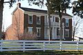
The Sylvester Marion and Frances Anne Stephens Baker House.
-
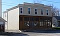
The Farmers Mercantile Co. Building in High Hill.
-
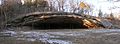
A view of Graham Cave, a National Historic Landmark.
-
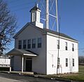
The historic High Hill School building.
_3.JPG)
_1.JPG)
_2.JPG)
