
National Register of Historic Places listings in Nemaha County, Nebraska facts for kids

Did you know that many special places in Nemaha County, Nebraska, are protected because of their history? These places are listed on the National Register of Historic Places. This list helps us remember and save buildings, bridges, and even old boats that are important to American history.
In Nemaha County, there are 13 different places on this special list. One of them is even a National Historic Landmark, which means it's super important to the whole country! Let's explore some of these amazing historic spots.
Contents
- Historic Places in Nemaha County
- Auburn Historic District
- John W. Bennett House
- Brownville Bridge
- Brownville Historic District
- Captain Meriwether Lewis Dredge
- First United Presbyterian Church of Auburn
- Legion Memorial Park
- Thomas J. Majors Farmstead
- Nemaha County Courthouse
- New Opera House (Auburn)
- Wilber T. Reed House
- St. John's Lutheran Church Complex
- US Post Office-Auburn
- Images for kids
Historic Places in Nemaha County
Auburn Historic District
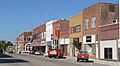
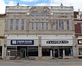
The Auburn Historic District is a special area in downtown Auburn. It includes the main commercial street and the area around the courthouse. This district was added to the list in 2014. It helps protect the old buildings that show what Auburn looked like long ago.
John W. Bennett House
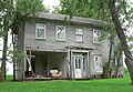
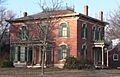
The John W. Bennett House is a historic home located near Brownville. It was added to the National Register in 1983. This house is a great example of old architecture in the area.
Brownville Bridge
The Brownville Bridge is a very important bridge that crosses the Missouri River. It connects Brownville in Nebraska to Atchison County, Missouri. This bridge, built for U.S. Route 136, was added to the list in 1993. It's a key link between the two states.
Brownville Historic District
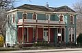
Brownville has its own historic district, which was recognized way back in 1970. This area includes many old streets and buildings near the Missouri River. It helps preserve the unique history and look of Brownville.
Captain Meriwether Lewis Dredge
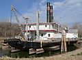
The CAPTAIN MERIWETHER LEWIS is not a building, but a special kind of boat called a dredge. It's located southeast of Brownville. This dredge was used to help keep the Missouri River clear for boats. It's so important that it was named a National Historic Landmark in 1977!
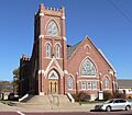
First United Presbyterian Church of Auburn
The First United Presbyterian Church is a beautiful church located at 1322 19th Street in Auburn. This historic church building was added to the National Register in 1982. It has been an important part of the community for many years.
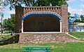
Legion Memorial Park
Legion Memorial Park is a historic park in Auburn. It's generally found between 10th and 11th Streets and H and J Streets. This park was added to the list in 2004. It's a place where people can relax and remember important events.
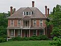
Thomas J. Majors Farmstead
The Thomas J. Majors Farmstead is an old farm located west of Peru. It's found at 800 Mulberry Street. This farm was recognized as a historic place in 1978. It shows what farming life was like in the past.
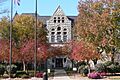
Nemaha County Courthouse
The Nemaha County Courthouse is a grand building located at 1824 N Street in Auburn. This is where many important county decisions are made. The courthouse was added to the National Register in 1990 because of its historical and architectural importance.
New Opera House (Auburn)
The New Opera House is an old theater located at 921 Central Avenue in Auburn. It was a place for entertainment and community gatherings long ago. This building was added to the list in 1988.
Wilber T. Reed House
The Wilber T. Reed House is another historic home in Auburn, located at 1204 N Street. This house was recognized in 1980. It's a great example of homes built in that time period.
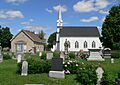
St. John's Lutheran Church Complex
The St. John's Lutheran Church Complex is a group of historic church buildings located at 63289 725 Road near Auburn. This complex was added to the National Register in 1979. It shows the history of the church community in the area.
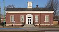
US Post Office-Auburn
The US Post Office in Auburn is located at 1320 Courthouse Avenue. This building is special because it has a beautiful mural inside called "Threshing," painted in 1939 by Ethel Magafan. It's one of only 12 post offices in Nebraska with such a mural. It was added to the list in 1992.
Images for kids
-
Auburn Historic District
-
John W. Bennett House
-

Brownville Bridge
-
Carson House in Brownville Historic District
-
CAPTAIN MERIWETHER LEWIS dredge
-
First United Presbyterian Church of Auburn
-
Legion Memorial Park
-
Thomas J. Majors Farmstead
-
Nemaha County Courthouse
-
New Opera House
-
Wilber T. Reed House
-
St. John's Lutheran Church Complex
-
US Post Office-Auburn


_from_NE.JPG)


_from_NE_1.JPG)
_3.JPG)

