
National Register of Historic Places listings in Newton County, Missouri facts for kids

Welcome to a special list of amazing places in Newton County, Missouri! These places are so important that they are officially recognized on the National Register of Historic Places. Think of it like a Hall of Fame for buildings, battlefields, and other spots that have a cool story to tell about America's past.
There are 12 different places in Newton County that have made it onto this special list. Each one helps us learn more about history, from old battles to important people and buildings. You can even see where these places are on a map using their special location coordinates!
Historic Places in Newton County
Have you ever wondered what makes a place "historic"? It means it's old and important, with a story that helps us understand the past. In Newton County, Missouri, there are several such places. They are all listed on the National Register of Historic Places. This list helps protect them so future generations can learn from them too!
First Battle of Newtonia Historic District
This area marks the spot of the First Battle of Newtonia, a big event during the American Civil War. It happened near the junction of Routes 86 and O in Newtonia. This district helps us remember the brave soldiers who fought there. It was added to the list in 2004.
Bonnie & Clyde Garage Apartment
This apartment in Joplin was once a hideout for the famous outlaws Bonnie Parker and Clyde Barrow. They were known for their crimes during the 1930s. This spot is about 3 miles south of Monument. It was added to the National Register in 2009.
George Washington Carver National Monument
This special place honors George Washington Carver, a brilliant scientist and inventor. He was born near Diamond. The monument is about 3 miles south of Monument. It became a National Monument in 1966. Carver's work changed farming and helped many people.
Jolly Mill
The Jolly Mill is an old mill located southwest of Pierce City. Mills like this were very important long ago for grinding grain into flour. It was added to the National Register in 1983. It's a great example of early industry in the area.
Lentz-Carter Merchandise Store
This old store is located at 744 Ozark Street in Stella. It was once a busy place where people bought all sorts of goods. Stores like this were the heart of small towns. It was added to the list in 2008.
Neosho Commercial Historic District
This district covers several streets in Neosho, including parts of Main, Spring, Washington, and Wood Streets. It's a collection of historic buildings that show what the town's business area looked like long ago. It was first listed in 1993, and more buildings were added in 2007.
Neosho High School
The old Neosho High School building is located at West McCord and North Wood Streets in Neosho. This building served as a place of learning for many generations of students. It was added to the National Register in 2002.
Neosho Wholesale Grocery Company
This building at 224 North Washington Street in Neosho was once a large grocery company. It played an important role in supplying food and goods to stores in the area. It was added to the list in 2013.
Mathew H. Ritchey House
The Mathew H. Ritchey House is located on Mill Street in Newtonia. This historic home has seen many changes over the years. It was added to the National Register in 1978.
Second Baptist Church
The Second Baptist Church is at 430 West Grant Street in Neosho. Churches often serve as important community centers and places of worship. This church was added to the National Register in 1996.
Second Battle of Newtonia Site
This site marks the location of the Second Battle of Newtonia, another important Civil War battle. It is located near the junction of Routes 86 and O at Newtonia. This area helps us remember the events of the past. It was added to the list in 2004.
|- class="vcard" ! style="background: #E6E6FA" | 1 | First Battle of Newtonia Historic District |
|
(#04000697)
| class="adr" | Junction of Routes 86 and O
36°53′05″N 94°11′02″W / 36.884722°N 94.183889°W
| class="note" |
|- class="vcard" ! style="background:#A8EDEF" | 2 | Bonnie & Clyde Garage Apartment
|

|
(#09000302)
| class="adr" | 3 miles (4.8 km) south of Monument
36°59′07″N 94°21′18″W / 36.985278°N 94.355°W
| class="note" |
|- class="vcard" ! style="background: #A8EDEF;" | 3 | George Washington Carver National Monument
|

|
(#66000114)
| class="adr" | 3 miles (4.8 km) south of Monument
36°59′07″N 94°21′18″W / 36.985278°N 94.355°W
| class="note" |
|- class="vcard" ! style="background:#A8EDEF" | 4 | Jolly Mill |
|
(#83004021)
| class="adr" | Southwest of Pierce City
36°53′50″N 94°04′18″W / 36.897222°N 94.071667°W
| class="note" |
|- class="vcard" ! style="background:#A8EDEF" | 5 | Lentz-Carter Merchandise Store |
|
(#08000799)
| class="adr" | 744 Ozark St.
36°45′38″N 94°11′32″W / 36.760608°N 94.192252°W
| class="note" |
|- class="vcard" ! style="background: #E6E6FA" | 6 | Neosho Commercial Historic District
|

|
(#93000722)
| class="adr" | Along sections of Main, Spring, Washington and Wood Sts.; also 114, 116, 118-120, 120, and 124-126 S. Wood St.
36°52′11″N 94°22′03″W / 36.869722°N 94.3675°W
| class="note" | Second set of boundaries represents a boundary increase of April 18, 2007
|- class="vcard" ! style="background:#A8EDEF" | 7 | Neosho High School |
|
(#02000906)
| class="adr" | W. McCord and N. Wood Sts.
36°52′17″N 94°22′08″W / 36.871389°N 94.368889°W
| class="note" |
|- class="vcard" ! style="background:#A8EDEF" | 8 | Neosho Wholesale Grocery Company
|

|
(#13000171)
| class="adr" | 224 N. Washington St.
36°52′17″N 94°22′02″W / 36.871405°N 94.367291°W
| class="note" |
|- class="vcard" ! style="background:#A8EDEF" | 9 | Mathew H. Ritchey House |
|
(#78003399)
| class="adr" | Mill St.
36°52′39″N 94°10′58″W / 36.8775°N 94.182778°W
| class="note" |
|- class="vcard" ! style="background:#A8EDEF" | 10 | Second Baptist Church
|

|
(#95001495)
| class="adr" | 430 W. Grant St.
36°52′31″N 94°22′29″W / 36.875278°N 94.374722°W
| class="note" |
|- class="vcard" ! style="background:#A8EDEF" | 11 | Second Battle of Newtonia Site |
|
(#04000698)
| class="adr" | Roughly an area northwest, southwest and southeast of the junction of Routes 86 and O at Newtonia
36°52′19″N 94°11′36″W / 36.871944°N 94.193333°W
| class="note" | |}
Images for kids
-
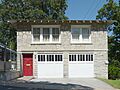
The garage apartment used by Bonnie and Clyde.
-
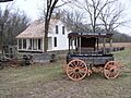
A view of the George Washington Carver National Monument.
-
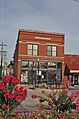
Buildings in the Neosho Commercial Historic District.
| Newtonia | Joplin | Diamond | Pierce City | Stella | Neosho | Neosho | Neosho | Newtonia | Neosho | Newtonia |
