
National Register of Historic Places listings in Okaloosa County, Florida facts for kids

Have you ever wondered about the oldest and most important places in your area? In Okaloosa County, Florida, there are special spots that are part of the National Register of Historic Places. This is a list of places, buildings, and areas that are important to the history of the United States. When a place is on this list, it means it's recognized for its unique past and is often protected so future generations can learn from it.
Okaloosa County has 9 places listed on the National Register. One of these is even a National Historic Landmark, which is an even higher honor! One place that used to be on the list was sadly lost. Let's explore some of these cool historic sites!
Historic Places You Can Visit
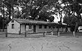
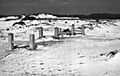
Camp Pinchot Historic District
Imagine a place where people used to gather for outdoor fun and learning! The Camp Pinchot Historic District is located on Eglin Air Force Base, near Fort Walton Beach. It was added to the National Register in 1998. This area shows how people used to enjoy nature and build communities in the past.
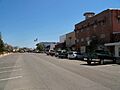
Crestview Commercial Historic District

In the heart of Crestview, you'll find the Crestview Commercial Historic District. This area includes many old buildings that were once busy shops and businesses. It gives us a peek into what downtown Crestview looked like many years ago. It became a historic district in 2006.
Eglin Field Historic District

Also on Eglin Air Force Base, the Eglin Field Historic District is a special area with buildings that tell the story of the base's early days. Eglin Air Force Base is a very important military base, and this district helps us remember its beginnings and how it grew. It was added to the list in 1998.
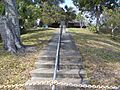
Fort Walton Mound

The Fort Walton Mound is a truly ancient and amazing place! Located in Fort Walton Beach, this large mound was built by Native Americans long, long ago. It's a National Historic Landmark, meaning it's one of the most important historic sites in the entire country. It was recognized way back in 1966. It helps us understand the early cultures that lived in Florida.
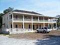
Gulfview Hotel Historic District

The Gulfview Hotel Historic District, also in Fort Walton Beach, includes the old Gulfview Hotel. This hotel was a popular spot for visitors enjoying Florida's beautiful beaches. It shows us what tourism was like in the past and how people enjoyed their vacations. It joined the National Register in 1992.
McKinley Climatic Laboratory

At Eglin Air Force Base, there's a unique place called the McKinley Climatic Laboratory. This isn't just any building; it's a giant laboratory where engineers can test airplanes and equipment in extreme weather conditions, like super cold or super hot temperatures! It's a very important part of aviation history and was listed in 1997.
World War II JB-2 Launch Sites

During World War II, Eglin Air Force Base was a secret testing ground for new weapons. The World War II JB-2 Launch Sites are where the United States tested early cruise missiles, similar to rockets. These sites are a reminder of the important role Florida played in developing technology during the war. They were added to the list in 1996.
A Lost Historic Place
Valparaiso Inn
The Valparaiso Inn in Valparaiso was once a beautiful and important building. It was listed on the National Register in 1978. Sadly, this historic inn was severely damaged by a fire in 1977 and then completely destroyed by another fire in 1980. Even though it's gone, its memory lives on as a part of Okaloosa County's history.
Images for kids
-

A view of the historic Camp Pinchot area.
-
Buildings in the Crestview Commercial Historic District.
-
Historic buildings at Eglin Field.
-
The ancient Fort Walton Mound.
-
The historic Gulfview Hotel.
-

An F-117 jet being tested in the McKinley Climatic Laboratory.
-
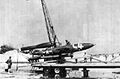
A JB-2 missile being launched during a test in 1945.
-
Another view of a JB-2 missile test.

