
National Register of Historic Places listings in Osborne County, Kansas facts for kids

Have you ever wondered about old buildings and places that are super important to history? In Osborne County, Kansas, there are several special spots listed on the National Register of Historic Places. This is a list of places across the United States that are recognized for their historical or architectural value. It's like a hall of fame for buildings, bridges, and other landmarks!
These places are protected and celebrated because they tell us stories about the past. They might be old libraries, train stations, or even a special spot that helps map the entire country. In Osborne County, there are 7 places currently on this important list. Let's explore some of them!
Historic Places in Osborne County
Here are some of the cool historic places you can find in Osborne County:
Downs Carnegie Library

The Downs Carnegie Library is a beautiful old building located at 504 Morgan in Downs. It was added to the National Register of Historic Places on June 25, 1987. This library was built with money from Andrew Carnegie, a famous businessman who helped fund thousands of libraries across the world. These libraries were often designed to be grand and welcoming, showing how important learning was.
Downs Missouri Pacific Depot

Also in Downs, you'll find the Downs Missouri Pacific Depot at 710 Railroad Street. This old train station was added to the list on October 11, 2001. Train depots like this one were once busy hubs where people traveled and goods were shipped. They were vital for connecting towns and cities before cars and planes became common. This depot reminds us of the important role trains played in American history.
East Fork Wolf Creek Pratt Truss Bridge
The East Fork Wolf Creek Pratt Truss Bridge is a historic bridge located near Delhi. It was listed on May 9, 2003. A "Pratt Truss" is a special way bridges are built using triangles to make them strong. This design was very popular for railway bridges and still stands as a testament to early engineering. It's a great example of how people built strong structures to cross rivers and creeks long ago.
Geodetic Center of the United States

One of the most unique places in Osborne County is the Geodetic Center of the United States, also known as the Meades Ranch Triangulation Station. It's about 17 miles southeast of Osborne. This spot was added to the National Register on October 9, 1973.
What's a geodetic center? It's a very important point used for mapping! Imagine drawing a giant map of the entire country. This spot was once considered the main reference point for all surveys and maps in the United States, including those used for things like GPS today. It's a fascinating place that shows how scientists and engineers work to understand our world.
Natoma Presbyterian Church
_from_SW_2.JPG)
The Natoma Presbyterian Church is located at 408 N. 3rd Street in Natoma. This beautiful church building was added to the National Register on November 21, 2006. Churches like this one are often important community centers and examples of local architecture from different time periods. They tell us about the history of faith and community life in the area.
Osborne County Courthouse

The Osborne County Courthouse is a grand building at 423 W. Main Street in Osborne. It was listed on April 26, 2002. Courthouses are very important buildings because they are where local government decisions are made and where legal matters are handled. This courthouse is a symbol of justice and community in Osborne County. Its architecture often reflects the pride and history of the county.
Osborne Public Carnegie Library

Another Carnegie library in the county is the Osborne Public Carnegie Library, found at 307 W. Main in Osborne. It was added to the National Register on June 25, 1987, the same day as the Downs Carnegie Library. This library, like others funded by Andrew Carnegie, was built to provide free access to books and learning for everyone in the community. Today, it is operated by the Osborne County Genealogical and Historical Society, helping people learn about their family and local history.
Former Listings
Sometimes, a building or place might be removed from the National Register of Historic Places. This can happen if it is significantly changed or no longer exists.
IOOF Lodge (Alton, Kansas)
The IOOF Lodge in Alton, located at the junction of Nicholas and Mill Streets, was once on the National Register. It was added on May 16, 2002, but was later removed on February 24, 2012. The IOOF Lodge was likely a meeting place for a fraternal organization called the Independent Order of Odd Fellows, which was common in many towns.
Images for kids
-
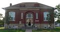
The historic Downs Carnegie Library building.
-
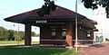
The old train station in Downs, Kansas.
-
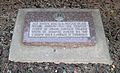
A replica plaque marking the Geodetic Center of the United States.
-
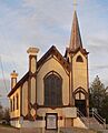
The Natoma Presbyterian Church.
-
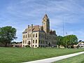
The Osborne County Courthouse.
-
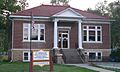
The Osborne Public Carnegie Library.
