Osborne, Kansas facts for kids
Quick facts for kids
Osborne, Kansas
|
|
|---|---|
|
City and County seat
|
|
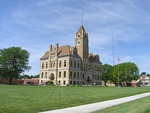
Osborne County Courthouse (2012)
|
|
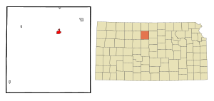
Location within Osborne County and Kansas
|
|
|
|
| Country | United States |
| State | Kansas |
| County | Osborne |
| Founded | 1871 |
| Incorporated | 1878 |
| Named for | Vincent Osborne |
| Area | |
| • Total | 1.54 sq mi (3.99 km2) |
| • Land | 1.54 sq mi (3.99 km2) |
| • Water | 0.00 sq mi (0.00 km2) |
| Elevation | 1,549 ft (472 m) |
| Population
(2020)
|
|
| • Total | 1,335 |
| • Density | 866.9/sq mi (334.6/km2) |
| Time zone | UTC-6 (CST) |
| • Summer (DST) | UTC-5 (CDT) |
| ZIP code |
67473
|
| Area code | 785 |
| FIPS code | 20-53325 |
| GNIS ID | 485636 |
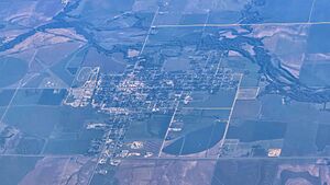
Osborne is a city in Osborne County, Kansas, United States. It is also the county seat, which means it's where the main government offices for the county are located. In 2020, about 1,335 people lived in Osborne.
Contents
History of Osborne
Settlers from southeastern Pennsylvania first founded Osborne City in May 1871. They named the new settlement after Vincent B. Osborne. He was a veteran who fought for the Union Army during the American Civil War. Osborne County is also named after him.
Osborne City became the main county seat in November 1872. A judge officially declared it a city in May 1873. However, the people living there didn't properly set up a local government. Five years later, they tried again, and this time it worked. The settlement officially became a city in 1878. By the mid-1890s, the word "City" was dropped from its name. In 1878, a bridge was built over the Solomon River in Osborne.
Geography of Osborne
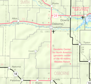
Osborne is located in north-central Kansas. It sits where two major roads, U.S. Route 281 and U.S. Route 24, meet. The city is about 134 miles (216 km) northwest of Wichita. It's also about 219 miles (352 km) west-northwest of Kansas City. Denver is about 339 miles (546 km) to the east.
Osborne is on the north side of the South Fork Solomon River. This area is part of the Smoky Hills region, which is a section of the larger Great Plains. The Osborne Canal runs along the northern edge of the city. This canal is part of a water project by the U.S. Bureau of Reclamation.
The city covers a total area of about 1.56 square miles (4.04 square kilometers). All of this area is land.
Climate in Osborne
Osborne has a varied climate. July is usually the warmest month of the year. January is typically the coldest month. May is the wettest month, meaning it gets the most rain.
The highest temperature ever recorded in Osborne was 116 °F (47 °C) in 1940. The lowest temperature ever recorded was a very cold -31 °F (-35 °C) in 1989.
| Climate data for Osborne, Kansas | |||||||||||||
|---|---|---|---|---|---|---|---|---|---|---|---|---|---|
| Month | Jan | Feb | Mar | Apr | May | Jun | Jul | Aug | Sep | Oct | Nov | Dec | Year |
| Record high °F (°C) | 80 (27) |
87 (31) |
94 (34) |
106 (41) |
105 (41) |
113 (45) |
116 (47) |
113 (45) |
112 (44) |
103 (39) |
88 (31) |
82 (28) |
116 (47) |
| Mean daily maximum °F (°C) | 39 (4) |
46 (8) |
56 (13) |
67 (19) |
75 (24) |
87 (31) |
93 (34) |
91 (33) |
82 (28) |
71 (22) |
53 (12) |
42 (6) |
67 (20) |
| Daily mean °F (°C) | — | — | — | — | — | — | — | — | — | 71 (22) |
— | — | — |
| Mean daily minimum °F (°C) | 12 (−11) |
17 (−8) |
26 (−3) |
37 (3) |
48 (9) |
59 (15) |
65 (18) |
62 (17) |
52 (11) |
38 (3) |
25 (−4) |
16 (−9) |
38 (3) |
| Record low °F (°C) | −24 (−31) |
−22 (−30) |
−17 (−27) |
9 (−13) |
21 (−6) |
33 (1) |
41 (5) |
38 (3) |
18 (−8) |
6 (−14) |
−10 (−23) |
−31 (−35) |
−31 (−35) |
| Average precipitation inches (mm) | 0.60 (15) |
0.80 (20) |
2.21 (56) |
2.58 (66) |
4.02 (102) |
3.20 (81) |
3.91 (99) |
3.12 (79) |
2.30 (58) |
1.63 (41) |
1.60 (41) |
0.76 (19) |
26.73 (677) |
| Source: The Weather Channel | |||||||||||||
Population of Osborne
| Historical population | |||
|---|---|---|---|
| Census | Pop. | %± | |
| 1880 | 719 | — | |
| 1890 | 1,174 | 63.3% | |
| 1900 | 1,075 | −8.4% | |
| 1910 | 1,566 | 45.7% | |
| 1920 | 1,635 | 4.4% | |
| 1930 | 1,881 | 15.0% | |
| 1940 | 1,876 | −0.3% | |
| 1950 | 2,068 | 10.2% | |
| 1960 | 2,049 | −0.9% | |
| 1970 | 1,980 | −3.4% | |
| 1980 | 2,120 | 7.1% | |
| 1990 | 1,778 | −16.1% | |
| 2000 | 1,607 | −9.6% | |
| 2010 | 1,431 | −11.0% | |
| 2020 | 1,335 | −6.7% | |
| U.S. Decennial Census | |||
2020 Census Information
The 2020 United States census counted 1,335 people living in Osborne. There were 602 households and 349 families. Most of the people (94.53%) were white. A small number were from other racial backgrounds. About 1.87% of the population identified as Hispanic or Latino.
About 24.3% of households had children under 18. Many households (36.7%) were made up of single individuals. About 19.6% of households had someone aged 65 or older living alone. The average household had 2 people.
The median age in Osborne was 48.6 years. This means half the people were older and half were younger than 48.6. About 21.1% of the population was under 18.
2010 Census Information
In 2010, the city had 1,431 people. There were 633 households and 390 families. Most residents (97.7%) were White. About 1.3% of the population was Hispanic or Latino.
About 27.3% of households had children under 18. Many households (36.0%) were individuals living alone. About 18.6% of these were people aged 65 or older. The average household size was 2.16 people.
The median age in 2010 was 48.1 years. About 21.7% of residents were under 18. About 27% were 65 years or older.
Economy of Osborne
In 2013, about 65.4% of people over 16 years old were working or looking for work. Most of these people (62.8%) had jobs. The types of jobs people had varied. Many worked in management, business, science, and arts (28.7%). Others worked in sales and office jobs (27.4%).
The cost of living in Osborne is lower than the average for the United States. For example, if the U.S. average is 100, Osborne's cost of living is 79.4. This means it's generally cheaper to live there. In 2013, the average home value was $42,400.
Education in Osborne
The Osborne USD 392 public school district serves the community. It provides public education from kindergarten through 12th grade. There are two schools in the city:
- Osborne Elementary School (for Grades K-6)
- Osborne Junior/Senior High School (for Grades 7-12)
Transportation in Osborne
U.S. Route 281 goes north and south through Osborne. It meets U.S. Route 24, which runs east and west, just north of the city. At this meeting point, U.S. 24 turns north and shares the road with U.S. 281 for a bit.
The Osborne Municipal Airport is located just southeast of the city. It is mainly used for general aviation, which means smaller, private planes rather than large commercial flights.
Osborne is also a stop for two different train lines. It is the western end of a line for the Kyle Railroad. It is also the northwestern end of a line for the Kansas & Oklahoma Railroad.
Media in Osborne
Osborne has one local newspaper. It's called the Osborne County Farmer and it comes out once a week. The city is also part of the Wichita-Hutchinson, Kansas television market. This means people in Osborne watch TV channels from that larger area.
Culture and Attractions
Points of Interest in Osborne
- Osborne County Historical Museum: This museum shows off items from the area's history. You can see old farm tools, clothes from different time periods, and items from American Indian cultures. The museum also has a one-room schoolhouse from 1912 on its property.
- Geodetic Center Marker: At the north end of the city, there's a park with information about the geodetic center of North America. This special point is about 18 miles (29 km) south-southeast of Osborne. The park has a copy of the marker found at the actual center.
Notable People from Osborne
Many interesting people were born in or have lived in Osborne, including:
- Chris Arpad (1967- ), a steel drummer
- Fred Cornwell (1961- ), a football tight end
- Josh Eilert (1983- ), an American basketball coach
- Edward L. Kessel (1904-1997), a biologist
- Joe Miller (1967- ), a judge and politician from Alaska
- Elsie Reasoner Ralph (1878-1913), known as the first female war correspondent in U.S. history
- Lee Wykoff (1898-1974), a professional wrestler
See also
 In Spanish: Osborne (Kansas) para niños
 | Janet Taylor Pickett |
 | Synthia Saint James |
 | Howardena Pindell |
 | Faith Ringgold |


