South Fork Solomon River facts for kids
Quick facts for kids South Fork Solomon River |
|
|---|---|

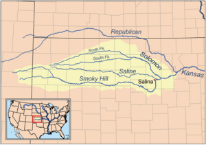
Map of the Smoky Hill drainage basin including the South Fork Solomon River
|
|
| Country | United States |
| State | Kansas |
| Physical characteristics | |
| Main source | Sherman County, Kansas 3,503 ft (1,068 m) 39°14′45″N 101°26′46″W / 39.24583°N 101.44611°W |
| River mouth | Waconda Lake Cawker City, Kansas 1,453 ft (443 m) 39°28′23″N 98°26′00″W / 39.47306°N 98.43333°W |
| Length | 292 mi (470 km) |
| Basin features | |
| Watersheds | South Fork Solomon-Solomon-Smoky Hill-Kansas-Missouri-Mississippi |
The South Fork Solomon River is a river in the central Great Plains of North America. It flows for about 292 miles (470 kilometers). This entire river is located within the state of Kansas in the United States. It is a smaller river that flows into the larger Solomon River.
Contents
Where Does the River Flow?
The South Fork Solomon River begins in Sherman County, Kansas. It then flows towards the east. The river passes through Thomas and Sheridan counties. After that, it enters Graham County.
Journey Through Graham County
As the river moves through Graham County, it generally follows the path of Highway 24. It enters Graham County near a town called Studley. The river leaves Graham County about 5 miles (8 kilometers) southwest of Nicodemus.
Towns Along the River
The South Fork Solomon River flows past several towns. These include Bogue, Hill City, Penokee, Morland, and Studley.
Webster Reservoir
The river's flow is stopped by a dam in Rooks County. This dam creates a large body of water called Webster Reservoir. This reservoir is located about eight miles west of Stockton, Kansas.
Joining Other Rivers
Finally, the South Fork Solomon River meets the North Fork Solomon River. This meeting point is at Waconda Lake. Waconda Lake is found in the northwestern part of Mitchell County. When these two rivers join, they form the main Solomon River.
 | Toni Morrison |
 | Barack Obama |
 | Martin Luther King Jr. |
 | Ralph Bunche |

