Webster Reservoir facts for kids
Quick facts for kids Webster Reservoir |
|
|---|---|

|
|
| Location | Rooks County, Kansas |
| Coordinates | 39°24′30″N 99°25′28″W / 39.40833°N 99.42444°W |
| Type | Reservoir |
| Primary inflows | South Fork Solomon River |
| Primary outflows | South Fork Solomon River |
| Catchment area | 1,150 sq mi (3,000 km2) |
| Basin countries | United States |
| Managing agency | U.S. Bureau of Reclamation |
| Built | March 1953 |
| First flooded | May 3, 1956 |
| Max. length | 7 miles (11 km) |
| Surface area | 3,767 acres (15.24 km2) |
| Max. depth | 42 feet (13 m) |
| Water volume | Full: 76,157 acre⋅ft (93,938,000 m3) Current (Nov. 2015): 17,091 acre⋅ft (21,081,000 m3) |
| Shore length1 | 27 miles (43 km) |
| Surface elevation | Full: 1,893 ft (577 m) Current (Nov. 2015): 1,870 ft (570 m) |
| Settlements | Stockton, Damar, Webster |
| 1 Shore length is not a well-defined measure. | |
Webster Reservoir is a large human-made lake in Rooks County, Kansas, United States. The U.S. Bureau of Reclamation built and manages it. This reservoir helps control floods, provides water for farms, and is a popular spot for fun activities. Webster State Park is right on its shore, offering lots of things to do outdoors.
Contents
Building Webster Reservoir
The idea to build Webster Dam and Reservoir was approved as part of a big plan called the Pick-Sloan Missouri Basin Program. After a huge flood in 1951, the U.S. Bureau of Reclamation decided this project could really help control floods and provide water for farming in the area.
Workers started building the dam in March 1953. There were some money problems and bad weather, which caused many delays over the next few years. The small town of Webster, which the reservoir is named after, was in the way. So, the town had to move about 2 miles (3.2 km) to the southeast.
Water began filling the reservoir on May 3, 1956. The Webster project officially started working on September 1, 1956. Later, local farmers created the Webster Irrigation District No. 4. They got the right to use water from the reservoir in December 1956. More building work started in July 1957. This included a special dam near Woodston, Kansas and the Osborne Canal to carry water to farms. All this was finished by April 1961.
Where is Webster Reservoir?
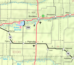
Webster Reservoir is in the northwestern part of Kansas. It sits on the western edge of the Smoky Hills region. This area is part of the larger Great Plains. The entire reservoir is located within Rooks County.
The reservoir is held back by Webster Dam at its eastern end. The dam is about 1,893 feet (577 m) above sea level. The South Fork Solomon River flows into the reservoir and also flows out of it.
You can find U.S. Route 24 running east and west north of the reservoir. Kansas Highway 258 goes north and south right over the top of Webster Dam. The only small community near the reservoir is Webster, Kansas, which is just southeast of the dam.
How Water Levels Change
The amount of water in Webster Reservoir changes. This depends on how much rain falls and how much water flows into it. The reservoir is divided into different sections based on how much water it holds. When it's considered "full," Webster Reservoir has a surface area of 3,767 acres (15.24 km2). At this point, its surface is about 1,893 feet (577 m) high. It holds about 76,157 acre-feet (93,938,000 m3) of water.
About Webster Dam
Webster Dam is a large earth-fill dam. This means it's made mostly of dirt and rock. It stands 154 feet (47 m) tall and is 10,604 feet (3,232 m) long. The very top of the dam is 1,944 feet (593 m) above sea level.
Who Manages the Reservoir?
The U.S. Bureau of Reclamation is in charge of running and taking care of Webster Dam and Reservoir. The Kansas Department of Wildlife, Parks and Tourism (KDWP) also helps. They manage a large area of land around the reservoir. This area is about 8,018 acres (32.45 km2) and is called the Webster Wildlife Area. It stretches upstream along the South Fork Solomon River.
Fun Things to Do at Webster Reservoir
The KDWP manages Webster State Park, which is right on the shore of the reservoir. The park covers about 880 acres (3.6 km2). It has two main parts: the Oldtown Area on the north side and the Goose Flat Area on the south side. Both areas have places to launch boats and camp overnight.
The Oldtown Area offers even more fun! You can find an amphitheater there for shows, swimming beaches, playgrounds, and a hiking trail.
Webster Reservoir is a great place for fishing. You can also hunt on the public land around the reservoir. However, hunting rules are stricter in the Wildlife Area.
Wildlife at Webster Reservoir
Many different kinds of fish live in Webster Reservoir. These include bluegill, channel and flathead catfish, crappie, largemouth and smallmouth bass, rainbow trout, walleye, white bass, and wiper.
Around the reservoir, you might see various animals. These include deer, ducks, pheasants, quail, and wild turkeys. You might even spot Bald eagles flying overhead!
 | William L. Dawson |
 | W. E. B. Du Bois |
 | Harry Belafonte |


