Webster, Kansas facts for kids
Quick facts for kids
Webster, Kansas
|
|
|---|---|

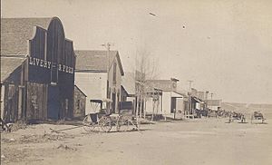
Webster street scene (est. early 1900s)
|
|

|
|
| Country | United States |
| State | Kansas |
| County | Rooks |
| Township | Belmont |
| Founded | late 1870s |
| Platted | 1885 |
| Named for | Daniel Webster |
| Elevation | 1,870 ft (570 m) |
| Time zone | UTC-6 (CST) |
| • Summer (DST) | UTC-5 (CDT) |
| ZIP code |
67669
|
| Area code | 785 |
| FIPS code | 20-76265 |
| GNIS ID | 484592 |
Webster was a small community in Rooks County, Kansas, United States. It was not officially a city or town, but rather an unincorporated community.
Contents
History of Webster
The community of Webster started in the late 1870s. It was located in the Solomon Valley, right by the South Fork Solomon River. Webster actually grew from two smaller settlements.
How Webster and Belmont Joined
One settlement, called Webster, was on the north side of the river. The other, called Belmont, was on the south side. Belmont began as a trading post in 1876. But because of floods, the people of Belmont had to move. They moved across the river and joined the Webster settlement.
Belmont tried to get a post office first. However, their request was turned down. Another town in Kansas already had that name. So, Webster was given a post office instead, in 1879.
Growth of the Town
Webster was named after a famous person, Daniel Webster. The town was officially mapped out in 1885. Even though it grew, Webster was never made an official city.
By 1888, Webster was a busy place. It had two doctors and two churches. There was also a school and 24 different businesses. The town even had a big park called The Grove. This park was known for its very tall cottonwood trees. In 1910, about 200 people lived in Webster.
Why Webster Moved
In 1953, a decision was made to build the Webster Dam. This dam was going to be built on the South Fork Solomon River. The new Webster Reservoir would cover the area where the town of Webster was located.
Because of the dam, the entire town had to move. Webster was relocated about 2 miles to the southeast. However, many businesses and people decided not to move to the new spot.
Where Webster Was Located
The original site of Webster was in the Smoky Hills area of the Great Plains. It was about 0.5 miles (0.8 km) south-southeast of the Webster Dam.
The old town site is now underwater, beneath the Webster Reservoir. It was located at coordinates 39°24′06″N 99°26′09″W / 39.40167°N 99.43583°W.
Education in Webster
Webster had its own schools for many years. Webster High School closed its doors in 1963. The grade school in Webster closed a few years later, in 1969. The sports teams at Webster High School were known as the Webster Eagles.
Getting Around Webster
Webster was located where two unpaved county roads met. One road, called 11 Road, ran north and south. The other road, M Terrace, ran east and west.
 | Dorothy Vaughan |
 | Charles Henry Turner |
 | Hildrus Poindexter |
 | Henry Cecil McBay |


