Waconda Lake facts for kids
Quick facts for kids Waconda Lake |
|
|---|---|

|
|
| Location | Mitchell and Osborne counties in Kansas |
| Coordinates | 39°29′27″N 98°22′22″W / 39.49083°N 98.37278°W |
| Type | Reservoir |
| Primary inflows | North Fork Solomon River, South Fork Solomon River |
| Primary outflows | Solomon River |
| Catchment area | 2,559 sq mi (6,630 km2) |
| Basin countries | United States |
| Managing agency | U.S. Bureau of Reclamation |
| Built | November 1964 |
| First flooded | January 1969 |
| Max. length | 24 miles (39 km) |
| Surface area | 12,602 acres (51.00 km2) |
| Max. depth | 55 feet (17 m) |
| Water volume | Full: 219,420 acre⋅ft (270,650,000 m3) Current (Nov. 2015): 214,784 acre⋅ft (264,932,000 m3) |
| Shore length1 | 100 mi (160 km) |
| Surface elevation | Full: 1,456 ft (444 m) Current (Nov. 2015): 1,455 ft (443 m) |
| Settlements | Cawker City, Glen Elder |
| 1 Shore length is not a well-defined measure. | |
Waconda Lake, also known as Glen Elder Reservoir, is a large reservoir in Mitchell and Osborne County, Kansas in the United States. A reservoir is like a big, artificial lake that stores water. The U.S. Bureau of Reclamation built and manages Waconda Lake. It helps control floods and provides water for farms. People also enjoy visiting it for fun activities. Glen Elder State Park is a popular spot on the north side of the lake.
Contents
History of Waconda Lake
Before Waconda Lake was built, there was a special place called Waconda Spring. This was a natural spring where water flowed up from underground. In 1904, a company opened a resort there. Later, in 1907, it became a health spa where people came to relax and feel better.
The idea to build Glen Elder Dam was part of a bigger plan called the Pick–Sloan Missouri Basin Program. This plan was approved in 1944 to help control floods and provide water for farming. Glen Elder Dam was one of six dams planned for the Smoky Hill River area.
The U.S. Bureau of Reclamation started buying land in 1963. Construction of the dam and Waconda Lake began in November 1964. Even though some people wanted to save Waconda Spring, the health spa was taken down. In 1968, the spring was sealed up. The dam was finished in January 1969. The new reservoir then covered the area where the spring used to be.
The city of Beloit, Kansas needed more water. They asked to use water from Waconda Lake, and their request was approved. The lake also started providing water to three other rural areas. In 1976, the lake's water was approved for use in farming.
Where is Waconda Lake?
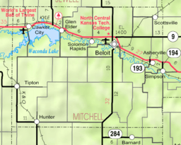
Waconda Lake is located in north-central Kansas. It sits in a hilly area known as the Smoky Hills region of the Great Plains. Most of the lake is in Mitchell County. A smaller part of its northwest side reaches into Osborne County.
The lake is held back by the Glen Elder Dam on its eastern side. The North Fork Solomon River and South Fork Solomon River flow into the lake from the west. The Solomon River flows out of the lake to the east. Smaller streams like Oak Creek and Granite Creek flow into the lake from the north. Carr Creek, Mill Creek, and Walnut Creek flow in from the south.
You can drive along the north side of the lake on U.S. Route 24 and Kansas Highway 9. Glen Elder Dam Road crosses the top of the dam. Lake Drive crosses the western end of the lake.
There are two towns on the north side of Waconda Lake. Cawker City is on the western end, and Glen Elder is on the eastern end.
How Big is Waconda Lake?
The size of Waconda Lake changes depending on how much water flows in and the weather. The U.S. Bureau of Reclamation divides the lake into different "pools" based on how much water it holds. When the lake is full, it covers about 12,602 acres (51.00 km2) of land. Its surface is about 1,456 feet (444 m) above sea level.
The bottom of the lake was originally about 1,385 feet (422 m) above sea level. Over time, dirt and sand have settled at the bottom, making it a bit higher.
Glen Elder Dam Structure
Glen Elder Dam is an embankment dam. This means it's made of earth and rock. It is 142 feet (43 m) tall and 15,275 feet (4,656 m) long. The top of the dam is 1,500 feet (460 m) above sea level.
The dam has a spillway with twelve large gates. This spillway helps control how much water flows out of the lake. It empties into a channel that joins the Solomon River. There's also another structure that manages water flowing directly into the river.
Managing the Lake
The U.S. Bureau of Reclamation is in charge of running and taking care of both Glen Elder Dam and Waconda Lake. The Kansas Department of Wildlife, Parks and Tourism (KDWPT) manages about 13,200 acres (53 km2) of land around the lake. This area is called the Glen Elder Wildlife Area.
Fun at Waconda Lake
The KDWPT runs Glen Elder State Park, which is on the north side of the lake. The park has a visitor's center, a place for boats (marina), an outdoor theater, boat ramps, and trails for hiking. You can also find swimming beaches and camping spots there. The park is home to the Waconda Heritage Village and hosts the yearly Waconda Indian Festival.
You can go fishing in Waconda Lake all year round. Some great fishing spots include The Bluffs, The Dam, Granite Creek, and the River. There are also over 12,000 acres (49 km2) of public land where you can go hunting.
Waconda Heritage Village
The Waconda Heritage Village is like a living museum inside Glen Elder State Park. It has a church called Hopewell Church, which was moved to the park in 1994. There's also a full-size model of the original Waconda Spring.
Wildlife at Waconda Lake
Many types of fish live in Waconda Lake. These include Channel catfish, crappie, flathead catfish, striped bass, walleye, and white bass.
Animals that live around the lake include mule deer, pheasants, quail, turkeys, and whitetail deer. Birds like Doves, ducks, and geese fly through the area during different seasons. In winter, you might even see Bald eagles and golden eagles visiting the lake.
 | Precious Adams |
 | Lauren Anderson |
 | Janet Collins |


