North Fork Solomon River facts for kids
Quick facts for kids North Fork Solomon River |
|
|---|---|

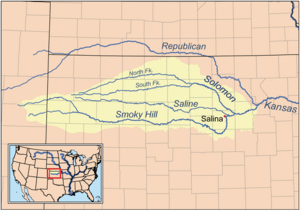
Map of the Smoky Hill drainage basin including the North Fork Solomon River
|
|
| Country | United States |
| State | Kansas |
| Physical characteristics | |
| Main source | Thomas County, Kansas 3,362 ft (1,025 m) 39°16′52″N 101°16′55″W / 39.28111°N 101.28194°W |
| River mouth | Waconda Lake Cawker City, Kansas 1,453 ft (443 m) 39°28′23″N 98°26′00″W / 39.47306°N 98.43333°W |
| Length | 287 mi (462 km) |
| Basin features | |
| Watersheds | North Fork Solomon-Solomon-Smoky Hill-Kansas-Missouri-Mississippi |
The North Fork Solomon River is a river in the middle of North America. It flows through the Great Plains region. This river is completely inside the state of Kansas in the United States. It is about 287-mile (462 km) long. The North Fork Solomon River flows into the Solomon River.
Where the River Flows
The North Fork Solomon River starts in the High Plains. This is a high, flat area in northwest Kansas. Its source is in west-central Thomas County. This spot is about 8 miles (13 km) southeast of Brewster, Kansas.
From its start, the river generally flows east-northeast. It then enters the Smoky Hills region of north-central Kansas. Southeast of Phillipsburg, Kansas, the river meets a smaller stream called Bow Creek. Together, they flow into Kirwin Reservoir.
After leaving the dam at Kirwin Reservoir, the river flows east. It then turns southeast when it gets close to Gaylord, Kansas. Just south of Cawker City, the North Fork joins the South Fork Solomon River. They both flow into Waconda Lake.
History of the River
In 1955, an important project was finished on the river. The U.S. Bureau of Reclamation built a dam near Kirwin, Kansas. This dam created Kirwin Reservoir. The main reason for building this dam was to help control floods.
 | Claudette Colvin |
 | Myrlie Evers-Williams |
 | Alberta Odell Jones |

