Kirwin Reservoir facts for kids
Quick facts for kids Kirwin Reservoir |
|
|---|---|

|
|
| Location | Phillips County, Kansas |
| Coordinates | 39°39′22″N 99°09′40″W / 39.65611°N 99.16111°W |
| Type | Reservoir |
| Primary inflows | North Fork Solomon River, Bow Creek |
| Primary outflows | North Fork Solomon River |
| Catchment area | 1,367 sq mi (3,540 km2) |
| Basin countries | United States |
| Managing agency | U.S. Bureau of Reclamation |
| Built | March 1952 |
| First flooded | October 1955 |
| Max. length | 9 miles (14 km) |
| Surface area | 5,079 acres (20.55 km2) |
| Max. depth | 49 feet (15 m) |
| Water volume | Full: 98,154 acre⋅ft (121,071,000 m3) Current (Nov. 2015): 34,199 acre⋅ft (42,184,000 m3) |
| Shore length1 | 37 miles (60 km) |
| Surface elevation | Full: 1,729 ft (527 m) Current (Nov. 2015): 1,713 ft (522 m) |
| Settlements | Kirwin, Glade |
| 1 Shore length is not a well-defined measure. | |
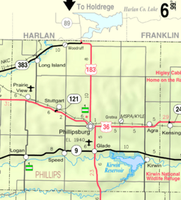
Kirwin Reservoir is a large, man-made lake in Phillips County, Kansas, United States. It's right next to the town of Kirwin in northern Kansas. The U.S. Bureau of Reclamation built and manages this reservoir. They use it to help control floods and provide water for farming. The Kirwin National Wildlife Refuge is also found along its shores.
Contents
Building Kirwin Reservoir: A Look at Its History
Why Kirwin Reservoir Was Built
In the 1930s, the Dust Bowl caused huge problems for farmers. Strong winds blew away the dry soil, making it hard to grow crops. Because of this, people in Kansas wanted a dam built on the Solomon River. They hoped a new lake would provide water for irrigation, helping farms recover.
The U.S. Bureau of Reclamation started looking for good spots to build a dam in 1939.
Getting Started: Laws and Delays
The Flood Control Act of 1944 gave permission to build Kirwin Dam and Reservoir. This project was part of a bigger plan called the Pick-Sloan Missouri Basin Program. However, World War II and its effects delayed the construction.
In 1950, local farmers created Kirwin Irrigation District No. 1. Then, a massive flood hit the Kansas River basin in 1951. This made people demand flood control projects even more.
Construction and Completion
The U.S. Congress then passed a law to start building Kirwin Dam right away. They wanted it for flood control first, with irrigation plans to be studied later.
Construction of Kirwin Dam began in March 1952. The main project was finished by August 1955. Water started filling the reservoir in October 1955. The next month, workers began building the Kirwin Canal and its branches. This canal system was completed in January 1958.
Kirwin National Wildlife Refuge: Protecting Nature
The Kirwin National Wildlife Refuge was created in 1954. It was set up around the reservoir to protect local wildlife. This was the first national wildlife refuge in Kansas. Its main goal is to help conserve and manage animals, especially birds that migrate through the area.
Where Is Kirwin Reservoir? A Geography Guide
Kirwin Reservoir is located in northern Kansas. It sits in the Smoky Hills area, which is part of the larger Great Plains. The entire reservoir is within Phillips County.
The reservoir is held back by Kirwin Dam at its eastern end. The dam is about 169 feet (52 m) tall and 12,646 feet (3,855 m) long. The main rivers that flow into the reservoir are the North Fork Solomon River and Bow Creek. The North Fork Solomon River also flows out of the reservoir.
Kansas Highway 9 runs to the north of the reservoir. East 1100 Road, a paved county road, is located just east of the reservoir. The town of Kirwin, Kansas is found right below the dam.
Understanding Kirwin Reservoir's Water Levels
How Water Levels Change
The amount of water in Kirwin Reservoir changes. This depends on how much rain falls and how much water flows into it. The U.S. Bureau of Reclamation divides the reservoir into different sections based on water volume.
When the reservoir is full, it covers about 5,079 acres (20.55 km2) of land. At this point, its surface is about 1,729 feet (527 m) above sea level. The total amount of water is about 98,154 acre⋅ft (121,071,000 m3).
Maximum Capacity
When the reservoir is filled to its very highest level, it can hold much more water. At its maximum, it covers about 14,660 acres (59.3 km2). The water surface is then about 1,773 feet (540 m) high. The total volume of water can reach 511,757 acre⋅ft (631,243,000 m3).
Over time, mud and dirt have settled at the bottom of the reservoir. This means the original streambed, which was at 1,662 feet (507 m), is now a bit higher due to this buildup.
The Structures That Make Kirwin Reservoir Work
Kirwin Dam: The Main Structure
Kirwin Dam is an embankment dam. This means it's made from layers of rolled earth. It stands 169 feet (52 m) tall and stretches 12,646 feet (3,855 m) across. The top of the dam is 1,779 feet (542 m) high.
At the south end of the dam, there's a concrete spillway. This spillway has 15 gates that can be opened to release water. The water flows into a short channel that joins the North Fork Solomon River. There are also outlets through the dam that release water directly into the river and the Kirwin Main Canal.
When the reservoir is at its highest water level, the spillway can release a lot of water. It can discharge about 96,000 cu ft/s (2,700 m3/s). The canal outlet can release 175 cu ft/s (5.0 m3/s), and the river outlet can release 100 cu ft/s (2.8 m3/s).
The Canal System: Bringing Water to Farms
The Kirwin Main Canal starts at the dam and goes east for about 13.4 miles (21.6 km). It runs along the north side of the river. This main canal then splits into two smaller canals:
- The Kirwin North Canal continues for another 14.3 miles (23.0 km).
- The Kirwin South Canal crosses the river using a siphon (a pipe that carries water uphill and then down). It then continues along the south side of the river for another 16.3 miles (26.2 km).
From these three main canals, there are about 38 miles (61 km) of smaller "lateral" canals. This entire network helps bring water to 11,435 acres (46.28 km2) of farmland for irrigation.
Who Manages Kirwin Reservoir?
The U.S. Bureau of Reclamation is in charge of running and maintaining Kirwin Dam and Reservoir. The local group, Kirwin Irrigation District No. 1, manages the canals and smaller water channels. The U.S. Fish and Wildlife Service oversees the water surface of the reservoir and most of the land around it. This area is part of the Kirwin National Wildlife Refuge.
Fun Activities at Kirwin Reservoir
Kirwin Reservoir is a great place for outdoor fun!
- Fishing: You can go sport fishing here all year round.
- Hunting: The Fish and Wildlife Service allows hunting for waterfowl (like ducks) and upland game (like pheasants) during certain seasons.
Wildlife at Kirwin Reservoir
Fish Species in the Reservoir
Many different kinds of fish live in Kirwin Reservoir, including:
Animals in the Wildlife Refuge
The land around the reservoir is part of the wildlife refuge. It's home to many animals, such as:
- mule and white-tailed deer
- hawks and owls
- pheasants and prairie chickens
- bobwhite quail
- Rio Grande turkeys
In the winter, you might even spot bald and golden eagles. Kirwin is also an important stop for water birds like cormorants and pelicans as they migrate.
Special Grasslands
A special part of the refuge is a Research Natural Area. This area has natural grasslands with bluestem and grama prairie grasses.
 | James Van Der Zee |
 | Alma Thomas |
 | Ellis Wilson |
 | Margaret Taylor-Burroughs |


