
Osborne County, Kansas facts for kids
Quick facts for kids
Osborne County
|
|
|---|---|

Osborne County Courthouse in Osborne (2012)
|
|

Location within the U.S. state of Kansas
|
|
 Kansas's location within the U.S. |
|
| Country | |
| State | |
| Founded | February 26, 1867 |
| Named for | Vincent B. Osborne |
| Seat | Osborne |
| Largest city | Osborne |
| Area | |
| • Total | 894 sq mi (2,320 km2) |
| • Land | 893 sq mi (2,310 km2) |
| • Water | 1.9 sq mi (5 km2) 0.2%% |
| Population
(2020)
|
|
| • Total | 3,500 |
| • Density | 3.9/sq mi (1.5/km2) |
| Time zone | UTC−6 (Central) |
| • Summer (DST) | UTC−5 (CDT) |
| Congressional district | 1st |
Osborne County is a county in the state of Kansas, USA. Its main city and county seat is Osborne. In 2020, about 3,500 people lived here. The county is named after Vincent Osborne, a brave captain from the American Civil War.
Contents
History of Osborne County
How Osborne County Began
Long, long ago, for thousands of years, the Great Plains of North America were home to nomadic Native American tribes. They moved around, following the animals they hunted.
In the 16th to 18th centuries, the Kingdom of France claimed a huge part of North America. But after a big war called the French and Indian War in 1762, France secretly gave this land to Spain.
Then, in 1802, Spain gave most of it back to France. A year later, in 1803, the United States bought a massive amount of land from France. This was called the Louisiana Purchase. It included most of what is now Kansas. The U.S. paid only about 2.83 cents per acre!
Kansas became a U.S. state in 1861. Six years later, in 1867, Osborne County was officially created.
Early Explorers and Native Americans
During the Civil War, Kansas leaders wanted to map out the western part of the state for future settlers. In 1862, surveyors D. E. Ballard and E. C. Manning started mapping Osborne County. Soldiers from Fort Riley protected them.
However, they had to stop their work because Native Americans lived in the area. These tribes, like the Cheyenne, had hunted in the Solomon River valley for many years. The valley was full of beavers, antelopes, elk, and buffalo. The Native Americans did not want settlers to come and change their way of life.
In 1866, the surveyors tried again. On July 21, a soldier named Edward Roche was killed by Native Americans while protecting the survey team. They finally finished mapping Osborne County on May 15, 1868.
Naming the County
The county was named after Captain Vincent B. Osborne. He was a Civil War soldier who lost his leg in a battle in 1865. He later became a state representative and judge. Sadly, he never actually visited the county named after him.
First Settlers Arrive
On January 14, 1870, George Wolberd made the first land claim in Osborne County. John M. Boer claimed land next to him the same day. These men were part of a group called the Rotterdam Dutch Colony.
Zarah Hill was the third person to claim land in the county in March 1870. That same month, brothers Charles and William Bullock built the first permanent non-Native American home. It was a double cabin with holes for defense and a log fence for their horses. This place became a stop for many early settlers and hunters.
Choosing the County Seat
When Osborne County was first created, it was connected to Mitchell County for legal matters. This meant that the first couple to get married in Osborne County had to travel to Beloit to get their marriage license!
In 1871, a man named Calvin Reasoner opened a store and founded a town called Arlington. He wanted Arlington to be the county seat. A county seat is the main town where the county government is located.
Another group, the Pennsylvania Colony, had founded a town called Osborne City. They wanted their town to be the county seat.
Reasoner tried to secretly hold a meeting to choose the county seat. But the Pennsylvania Colony found out! Many people from both sides showed up. They found out that Osborne County had enough people (724 residents) to become officially organized.
During the meeting, there was a big debate. The Pennsylvania Colony had more people there. They quickly voted for Osborne City to be the temporary county seat. Reasoner was surprised, but the Pennsylvania Colony had official papers from the state governor. So, Osborne City became the temporary county seat.
On September 12, 1871, Kansas Governor James Harvey officially declared Osborne County organized. Elections were held that November, and Osborne County was fully set up.
Geography of Osborne County
Osborne County covers about 894 square miles. Most of this is land (893 square miles), with a small amount of water (1.9 square miles). The South Fork Solomon River flows through the county. The land is mostly rolling prairies, which are wide, flat grasslands.
Did you know? The exact middle point of North America (called the geodetic center) is located right here in Osborne County! The geographic center of the 48 connected states is in the next county over, Smith County.
Counties Nearby
Osborne County shares borders with these other counties:
- Smith County (north)
- Jewell County (northeast)
- Mitchell County (east)
- Lincoln County (southeast)
- Russell County (south)
- Ellis County (southwest)
- Rooks County (west)
People of Osborne County

The number of people living in Osborne County has changed over the years.
- In 1870, there were only 33 people.
- By 1880, the population grew to over 12,500!
- The population stayed high for a while, but then started to decrease.
- In 2020, the population was 3,500.
Most people in Osborne County are White. A small number of people are from other racial backgrounds. The average age of people in the county in 2000 was 44 years old.
Education in Osborne County
Students in Osborne County attend schools in these unified school districts:
- Waconda USD 272
- Osborne County USD 392
- Paradise-Natoma-Waldo USD 399
Communities in Osborne County

Cities
Unincorporated Communities
These are smaller communities that are not officially cities.
Ghost Towns
These are towns that used to exist but are now abandoned.
- Banks
- Bristow
- Cheyenne
- Delhi
- Deliverance
- Dial
- Forney
- Free Will
- Handy
- Potterville
- Roundmound
- Twin Creek
- Vincent
- Yoxall
Images for kids
-
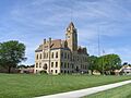
Osborne County Courthouse in Osborne (2012)
-
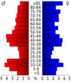
Population pyramid based on 2000 census age data
-
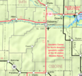
2005 map of Osborne County (map legend)
See also
 In Spanish: Condado de Osborne para niños
