Jewell County, Kansas facts for kids
Quick facts for kids
Jewell County
|
|
|---|---|

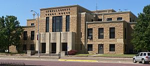
Jewell County Courthouse in Mankato (2014)
|
|

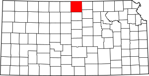
Location within the U.S. state of Kansas
|
|
 Kansas's location within the U.S. |
|
| Country | |
| State | |
| Founded | February 26, 1887 |
| Named for | Lewis R. Jewell |
| Seat | Mankato |
| Largest city | Mankato |
| Area | |
| • Total | 914 sq mi (2,370 km2) |
| • Land | 910 sq mi (2,400 km2) |
| • Water | 4.6 sq mi (12 km2) 0.5%% |
| Population
(2020)
|
|
| • Total | 2,932 |
| • Estimate
()
|
2,847 |
| • Density | 3.2/sq mi (1.2/km2) |
| Time zone | UTC−6 (Central) |
| • Summer (DST) | UTC−5 (CDT) |
| Area code | 785 |
| Congressional district | 1st |

Jewell County is a county located in the state of Kansas, USA. Its main city and county seat is Mankato. As of the 2020 census, about 2,932 people lived here. The county is named after Lewis Jewell, a brave soldier who was a lieutenant colonel in the 6th Regiment Kansas Volunteer Cavalry.
Contents
History of Jewell County
Early Days and Land Ownership
For thousands of years, the Great Plains of North America were home to nomadic Native American groups. In the 16th to 18th centuries, France claimed large parts of North America. After the French and Indian War in 1762, France secretly gave this land to Spain.
Becoming Part of the United States
In 1802, Spain returned most of the land to France. Then, in 1803, the United States bought a huge area, including what is now Kansas, from France. This was part of the Louisiana Purchase, a very important deal.
In 1854, the Kansas Territory was set up. Kansas officially became the 34th U.S. state in 1861. Jewell County was officially created in 1887. It was named to honor Lieutenant Colonel Lewis R. Jewell.
Railroad Connections
In 1887, the Atchison, Topeka and Santa Fe Railway built a train line. This line connected many towns, including Concordia and Webber, to places in Nebraska. This helped people and goods travel across the county. Today, this railroad is part of the BNSF Railway. Many local people still call it the "Santa Fe."
Geography of Jewell County
Jewell County covers about 914 square miles. Most of this area, about 910 square miles, is land. The remaining 4.6 square miles (0.5%) is water.
Neighboring Counties
Jewell County shares borders with several other counties:
- Nuckolls County, Nebraska (to the northeast)
- Republic County (to the east)
- Cloud County (to the southeast)
- Mitchell County (to the south)
- Osborne County (to the southwest)
- Smith County (to the west)
- Webster County, Nebraska (to the northwest)
Population and People
The number of people living in Jewell County has changed over the years. Here's a look at the population counts from different census years:
| Historical population | |||
|---|---|---|---|
| Census | Pop. | %± | |
| 1870 | 207 | — | |
| 1880 | 17,475 | 8,342.0% | |
| 1890 | 19,349 | 10.7% | |
| 1900 | 19,420 | 0.4% | |
| 1910 | 18,148 | −6.5% | |
| 1920 | 16,240 | −10.5% | |
| 1930 | 14,462 | −10.9% | |
| 1940 | 11,970 | −17.2% | |
| 1950 | 9,698 | −19.0% | |
| 1960 | 7,217 | −25.6% | |
| 1970 | 6,099 | −15.5% | |
| 1980 | 5,241 | −14.1% | |
| 1990 | 4,251 | −18.9% | |
| 2000 | 3,791 | −10.8% | |
| 2010 | 3,077 | −18.8% | |
| 2020 | 2,932 | −4.7% | |
| 2023 (est.) | 2,847 | −7.5% | |
| U.S. Decennial Census | |||
In 2000, there were 3,791 people living in Jewell County. Most residents were White (98.79%). A small number of people were Native American, Asian, Black, or Pacific Islander. About 0.71% of the population was Hispanic or Latino.
The average age in the county in 2000 was 46 years old. About 21.9% of the population was under 18. This means there were fewer young people compared to older adults.
Education in Jewell County
Students in Jewell County attend schools within a unified school district.
School Districts
- Rock Hills USD 107
Communities in Jewell County
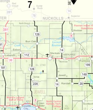
Jewell County has several cities and smaller communities.
Cities
Unincorporated Communities
These are smaller communities that are not officially cities. Some are also called Census-Designated Places (CDP) by the U.S. Census Bureau.
Ghost Towns
These are places where communities once existed but are now mostly abandoned.
- Dentonia
- Salem
Townships
Jewell County is divided into twenty-five smaller areas called townships. Each township includes the population of any cities within its borders.
- Allen
- Athens
- Browns Creek
- Buffalo
- Burr Oak
- Calvin
- Center
- Erving
- Esbon
- Grant
- Harrison
- Highland
- Holmwood
- Ionia
- Jackson
- Limestone
- Montana
- Odessa
- Prairie
- Richland
- Sinclair
- Vicksburg
- Walnut
- Washington
- White Mound
See also
 In Spanish: Condado de Jewell para niños
 | Bessie Coleman |
 | Spann Watson |
 | Jill E. Brown |
 | Sherman W. White |


