
National Register of Historic Places listings in Pembina County, North Dakota facts for kids

Have you ever wondered about really old buildings or places that are super important to history? In Pembina County, North Dakota, there are many such special spots! These places are listed on something called the National Register of Historic Places. It's like a special list kept by the United States government. Being on this list means a place is very important for its history, architecture, or what it tells us about the past.
This article will tell you about some of these amazing places in Pembina County. There are 13 different buildings and areas in the county that are on this important list. Let's explore them!
Historic Buildings and Sites
Many different kinds of places can be on the National Register. Some are old homes, some are churches, and others are even bridges or trails! Each one has a unique story.
Gingras House and Trading Post

The Gingras House and Trading Post is a very old place located northeast of Walhalla, North Dakota. It was added to the National Register in 1975. This site was once a busy trading post. Imagine people trading furs, supplies, and other goods here long ago! It gives us a peek into what life was like when pioneers and traders explored this area.
Gunlogson Farmstead Historic Site

Near Cavalier, North Dakota, you can find the Gunlogson Farmstead Historic Site. This farm was added to the list in 2008. A farmstead includes the main house, barns, and other buildings on a farm. This site helps us understand how farming families lived and worked in North Dakota many years ago. It shows us the history of agriculture in the region.
Pembina County Courthouse

The Pembina County Courthouse is in Cavalier, North Dakota. It became a historic place in 1980. A courthouse is a very important building where local government and legal matters happen. This building has seen many important decisions made for the county over the years. Its architecture also tells a story about the time it was built.
Walla Theater

The Walla Theater is located in Walhalla, North Dakota. It was added to the National Register in 2010. Theaters are special places where people go to watch movies or live shows. This old theater reminds us of how people used to entertain themselves and gather in their communities. It's a piece of local entertainment history!
Vikur Lutheran Church at Mountain
The Vikur Lutheran Church is in Mountain, North Dakota. This church became a historic site in 2013. Churches are often central to communities and have beautiful architecture. This church is important to the history of the people who settled in Mountain and their faith.
Other Important Places
There are several other interesting places on the National Register in Pembina County:
- Crystal Bridge: This bridge crosses Cart Creek in Crystal, North Dakota. It was listed in 1997. Old bridges are important because they show us how people built things and traveled in the past.
- Drayton United Methodist Church: This church is in Drayton, North Dakota. It was added to the list in 1979. Like other historic churches, it tells us about the community's past and its spiritual life.
- Grace Episcopal Church: You can find this church in Pembina, North Dakota. It became a historic place in 1994. It's another example of the important role churches played in early settlements.
- O'Connor House: This historic house is near St. Thomas, North Dakota. It was listed in 1980. Old homes often have unique designs and tell us about the families who lived there.
- Ridge Trail Historic District: This is a historic trail that runs through parts of Pembina and Walsh Counties. It was added in 2006. Trails are important because they show us old routes for travel and trade.
- US Customs House and Post Office-Pembina: This building is in Pembina, North Dakota. It was listed in 1989. Customs houses and post offices were very important for trade and communication, especially in border towns like Pembina.
These places help us learn about the past and understand how Pembina County grew and changed over time. They are important parts of North Dakota's history!
Images for kids
-
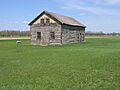
The historic Gingras House and Trading Post.
-
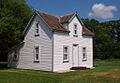
The Gunlogson House at the historic farmstead.
-
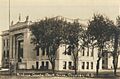
The Pembina County Courthouse in Cavalier.
-
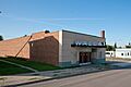
The Walla Theater in Walhalla.
