
National Register of Historic Places listings in Perry County, Alabama facts for kids

Have you ever wondered about old buildings and places that are super important to history? In Perry County, Alabama, there are many such places! This article is a list of buildings and areas in Perry County that are on the National Register of Historic Places.
The National Register of Historic Places is like a special list kept by the United States government. It helps protect places that are important because of their history, architecture, or what happened there. When a place is on this list, it means it's a valuable part of our country's story.
In Perry County, Alabama, there are 18 different properties and areas on this list. One of them is even a National Historic Landmark, which is an even higher level of historical importance! Let's explore some of these amazing places.
Historic Places in Perry County
Perry County is full of history, especially in the city of Marion and the town of Uniontown. Many of the places on the National Register are found in these areas.
Marion's Historic Gems
Marion is home to many historic buildings, including schools, churches, and beautiful old houses.
Schools and Colleges
Marion has a rich history of education.
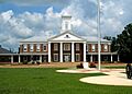
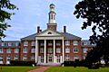
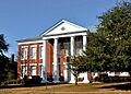
- Marion Military Institute: This school has two important buildings on the list. The Chapel and Lovelace Hall (listed in 1978) and the President's House (listed in 1979) are both recognized for their history. The institute has been training young people for a long time.
- Judson College Historic District: Judson College was a historic women's college. Its campus, including buildings like Jewitt Hall, is recognized as a historic district (listed in 1993). This means a whole area of the college is important.
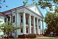
- Marion Female Seminary: This was another important school for women in Marion, listed in 1973. It played a big role in educating young women in the past.
- Phillips Memorial Auditorium: This auditorium is part of the Lincoln Normal School, which was very important for African American education. It was listed in 1990.
Historic Churches
Churches often stand as symbols of a community's history and faith.
- First Congregational Church of Marion: This church, located on Clay Street, was listed in 1982. It has been a significant place for worship and community gatherings for many years.
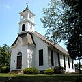
- Siloam Baptist Church: Found on Washington Street, Siloam Baptist Church was added to the list in 1982. It's another example of the beautiful and historic churches in Marion.
Old Houses and Districts
Marion also has many historic homes and neighborhoods.
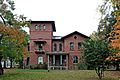
- Bryand Brand House: This house, located near Folsom, was listed in 2010. It's an example of the older homes in the area.
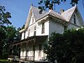
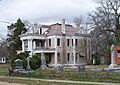
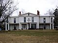
- Henry House: Located on South Washington Street, the Henry House was listed in 1986. It's also known as the Lowry-Ford-Henry House.
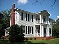
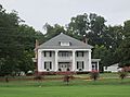
- Green Street Historic District: This district, listed in 1979, includes many historic homes along West Green Street. One famous house there is the Governor Andrew Moore House.
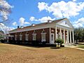
- Marion Courthouse Square Historic District: The area around the Perry County Courthouse is also historic, listed in 1996. It includes many important buildings that make up the heart of Marion.
- West Marion Historic District: This large district, listed in 1993, covers many streets in West Marion. It includes historic homes and buildings that show how the town grew over time.
- Moore-Webb-Holmes Plantation: Located near Marion, this plantation was listed in 2011. It's an important site for understanding the history of farming and life in the region.
Uniontown's Historical Treasures
The town of Uniontown also has several places on the National Register.
Grand Plantations
Uniontown is known for its beautiful old plantations.
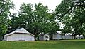
- Fairhope Plantation: Located east of Uniontown, this plantation was listed in 1992. It's a grand old estate with a lot of history.
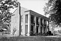
- Pitts' Folly: This historic home on Old Cahaba Road was listed in 1984. Its unique name hints at a fascinating past.
- Westwood: North of Uniontown, Westwood was listed in 1974, with an expanded boundary added in 1984. It's a significant plantation that tells a story of the area's past.
Uniontown Historic District
- Uniontown Historic District: This district, listed in 2000, covers a large part of Uniontown. It includes many historic buildings that show the town's development. Conita Manor is one of the notable buildings within this district.
A National Historic Landmark
One place in Perry County stands out as a National Historic Landmark.
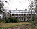
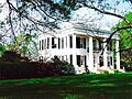
- Kenworthy Hall: This amazing house, located west of Marion, was given the special National Historic Landmark status in 1990. It's a truly important piece of American history and architecture.
These historic places in Perry County help us remember the past and understand how our communities came to be. They are important treasures for everyone to learn about and appreciate!
Images for kids
-
The Chapel and Lovelace Hall at Marion Military Institute.
-
The side view of Fairhope Plantation.
-
The First Congregational Church in Marion.
-
The Governor Andrew Moore House, part of the Green Street Historic District.
-
The Henry House in Marion.
-
Jewitt Hall at Judson College.
-
Kenworthy Hall, a National Historic Landmark.
-
The Perry County Courthouse, part of the Courthouse Square Historic District.
-
The historic Marion Female Seminary building.
-
A building at the Moore-Webb-Holmes Plantation.
-
Phillips Memorial Auditorium.
-
Pitts' Folly in Uniontown.
-
The President's House at Marion Military Institute.
-
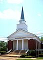
Siloam Baptist Church.
-
Conita Manor, located within the Uniontown Historic District.
-
Reverie, a historic home in the West Marion Historic District.
-
Westwood Plantation.


-Front.jpg)

