
National Register of Historic Places listings in Perry County, Missouri facts for kids

Have you ever wondered about old buildings and places that are super important to history? In Perry County, Missouri, there are nine special spots that are listed on the National Register of Historic Places. This is like a national list of places that are worth protecting because they tell us a lot about the past of the United States. These places can be old houses, churches, schools, or even natural landmarks. Each one has a unique story!
When a place is on this list, it means it's recognized for its historical, architectural, or archaeological importance. It helps people learn about the past and makes sure these places are preserved for future generations. Let's explore some of these cool historic sites in Perry County!
Contents
- Exploring Perry County's Historic Treasures
- Christian A. Bergt Farm: A Saxon Lutheran Legacy
- Concordia Log Cabin College: A School in a Log Cabin
- Doerr-Brown House: A Historic Home in Perryville
- Eggers and Company General Store: A Hub of Community Life
- Perry County Courthouse: The Center of Local Government
- St. Mary's of the Barrens Historic District: A Place of Faith
- Shelby-Nicholson-Schindler House: Another Perryville Gem
- Tower Rock: A Natural Landmark in the Mississippi River
- Images for kids
Exploring Perry County's Historic Treasures
Perry County is home to several fascinating places that have earned a spot on the National Register. These sites offer a glimpse into the lives of people who lived here long ago and the important events that shaped the area.
Christian A. Bergt Farm: A Saxon Lutheran Legacy
The Christian A. Bergt Farm is located east of Frohna, Missouri. It was added to the National Register on January 10, 1980. This farm is part of the larger Saxon Lutheran Memorial, which celebrates the history of German immigrants who came to this area in the 1830s. They were Lutherans seeking religious freedom. The farm helps us understand how these early settlers lived and farmed.
Concordia Log Cabin College: A School in a Log Cabin
Imagine going to college in a log cabin! The Concordia Log Cabin College in Altenburg, Missouri, was listed on November 21, 1978. This simple log cabin was once a very important school. It was where the first students of Concordia Seminary, a famous Lutheran theological school, began their studies in 1839. It shows how dedicated these early settlers were to education, even in tough conditions.
Doerr-Brown House: A Historic Home in Perryville
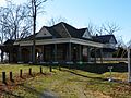
The Doerr-Brown House is found at 17 East St. Joseph Street in Perryville, Missouri. It became a historic site on November 14, 1980. This house is a great example of the architecture from its time. It helps us see what homes looked like and how people lived in Perryville many years ago.
Eggers and Company General Store: A Hub of Community Life
The Eggers and Company General Store is located at 19 County Road 32B in Farrar, Missouri. It was added to the National Register on June 21, 2007. General stores were once the heart of small communities. They sold everything from food to tools and were places where people gathered and shared news. This store gives us a peek into the daily life and commerce of the past.
Perry County Courthouse: The Center of Local Government
The Perry County Courthouse stands at 15 West Sainte Marie Street in Perryville, Missouri. It was listed on May 23, 2016. Courthouses are often important historical buildings because they are where local laws are made and justice is served. This building has seen many important decisions and events in Perry County's history.
St. Mary's of the Barrens Historic District: A Place of Faith
Southwest of the junction of West Saint Joseph Street and Missouri Route 51 in Perryville, Missouri, you'll find the St. Mary's of the Barrens Historic District. This district was recognized on August 25, 1995. It includes the historic St. Mary's of the Barrens Catholic Church, which is a significant religious site. It shows the strong faith and community spirit of the people who settled here.
Shelby-Nicholson-Schindler House: Another Perryville Gem
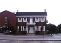
The Shelby-Nicholson-Schindler House is located at 701 West St. Joseph Street in Perryville, Missouri. It was added to the National Register on July 24, 1974. Like the Doerr-Brown House, this home provides insights into the architectural styles and family life of earlier times in Perryville.
Tower Rock: A Natural Landmark in the Mississippi River
Not all historic places are buildings! Tower Rock is a unique natural landmark located about 1 mile south of Wittenberg, Missouri, in the Mississippi River. It was listed on February 26, 1970. This tall, rocky island has been a landmark for travelers on the Mississippi River for centuries. It's a reminder of the powerful natural forces that shaped the landscape.
Images for kids
-
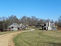
Cabins at the Saxon Lutheran Memorial, part of the Christian A. Bergt Farm.
-
The historic log cabin of Concordia College Museum in Altenburg.
-
The Doerr-Brown House in Perryville.
-
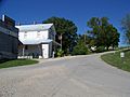
The Eggers and Company General Store in Farrar.
-
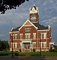
The Perry County Courthouse in Perryville.
-
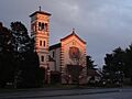
St. Mary of the Barrens Church in Perryville.
-
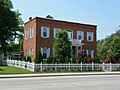
The Shelby-Nicholson-Schindler House.
-
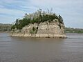
Tower Rock in the Mississippi River near Wittenberg.


_church.jpg)


