
National Register of Historic Places listings in Pitt County, North Carolina facts for kids

Did you know that some places are so special and important that they are officially recognized and protected? In Pitt County, North Carolina, many buildings, homes, and even whole neighborhoods are listed on the National Register of Historic Places. This is a list kept by the United States government to help save and celebrate places that have a lot of history.
These historic places tell us stories about the past. They show us how people lived, worked, and built things many years ago. By keeping them safe, we can learn from history and make sure these special spots are around for future generations to enjoy.
Contents
- Historic Places in Pitt County
- Ayden Historic District
- College View Historic District
- Cox-Ange House
- Dickinson Avenue Historic District
- Dupree-Moore Farm
- Falkland Historic District
- Farmville Historic District
- E. B. Ficklen House
- James L. Fleming House
- Fountain Historic District
- Greenville Commercial Historic District
- Greenville Tobacco Warehouse Historic District
- Greenwreath
- Grimesland Plantation
- Spencer Harris House
- Robert Lee Humber House
- Jones-Lee House
- Kittrell-Dail House
- Robert J. Lang Jr. House
- William H. Long House
- Benjamin May-Lewis House
- Jesse R. Moye House
- Oakmont
- Pitt County Courthouse
- Red Banks Primitive Baptist Church
- Renston Rural Historic District
- Thomas Sheppard Farm
- Skinnerville-Greenville Heights Historic District
- St. John's Episcopal Church
- U.S. Post Office (Greenville, North Carolina)
- Images for kids
Historic Places in Pitt County
Here are some of the cool historic places you can find in Pitt County:
Ayden Historic District
- The Ayden Historic District is a special area in Ayden, North Carolina. It was added to the list on August 26, 1994. This district includes many old buildings that show how the town grew over time.
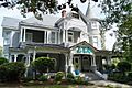
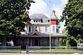
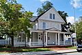
College View Historic District
- In Greenville, North Carolina, the College View Historic District became historic on March 19, 1992. This neighborhood has unique old homes and buildings that give us a peek into Greenville's past.
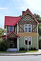
Cox-Ange House
- The Cox-Ange House is a single historic home located in Winterville, North Carolina. It was recognized on October 6, 2000. This house is a great example of older architecture in the area.
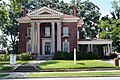
Dickinson Avenue Historic District
- Another historic area in Greenville, North Carolina is the Dickinson Avenue Historic District. It joined the list on March 1, 2007. This district highlights important commercial and residential buildings.
Dupree-Moore Farm
- The Dupree-Moore Farm near Falkland, North Carolina was added on August 28, 2012. This farm gives us a look at how farming life used to be in Pitt County.
Falkland Historic District
- The Falkland Historic District in Falkland, North Carolina was listed on October 3, 2012. It protects a collection of historic buildings in the heart of the town.
Farmville Historic District
- In Farmville, North Carolina, the Farmville Historic District was recognized on October 21, 1993. This district helps preserve the town's unique historical character.
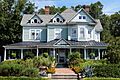
E. B. Ficklen House
- The E. B. Ficklen House is a historic home in Greenville, North Carolina. It was added to the list on December 20, 1984, showing its importance to the city's history.
James L. Fleming House
- Also in Greenville, North Carolina, the James L. Fleming House became historic on July 21, 1983. This house is a notable example of older residential architecture.
Fountain Historic District
- The Fountain Historic District in Fountain, North Carolina was listed on May 3, 2016. It helps protect the historic center of this small town.
Greenville Commercial Historic District
- The Greenville Commercial Historic District in Greenville, North Carolina was added on August 21, 2003. This area includes many old shops and businesses that were important to Greenville's economy.
Greenville Tobacco Warehouse Historic District
- Another important district in Greenville, North Carolina is the Greenville Tobacco Warehouse Historic District. It was listed on July 17, 1997. This area shows the history of tobacco farming and trade in the region.
Greenwreath
- Greenwreath, located west of Greenville, North Carolina, was recognized on April 29, 1982. This historic property has a unique story from the past.
Grimesland Plantation
- The Grimesland Plantation near Grimesland, North Carolina was added to the list on March 31, 1971. It is one of the older historic listings in the county.
Spencer Harris House
- The Spencer Harris House near Falkland, North Carolina became historic on January 20, 2005. It's another example of a well-preserved old home.
Robert Lee Humber House
- The Robert Lee Humber House in Greenville, North Carolina was listed on July 9, 1981. This house has historical importance to the city.
Jones-Lee House
- The Jones-Lee House in Greenville, North Carolina was added on November 25, 1980. It's a significant part of Greenville's architectural history.
Kittrell-Dail House
- The Kittrell-Dail House near Renston, NC was recognized on March 24, 2000. This home helps tell the story of rural life in Pitt County.
Robert J. Lang Jr. House
- The Robert J. Lang Jr. House near Fountain, North Carolina was listed on August 23, 1990. It's another example of a historic residence in the county.
William H. Long House
- The William H. Long House in Greenville, North Carolina was added on April 15, 1982. It's a historic building that contributes to the city's heritage.
Benjamin May-Lewis House
- The Benjamin May-Lewis House near Farmville, North Carolina was recognized on June 20, 1985. This house holds historical value for the area.
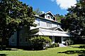
Jesse R. Moye House
- The Jesse R. Moye House in Greenville, North Carolina was listed on October 17, 1997. It's an important part of Greenville's collection of historic homes.
Oakmont
- Oakmont in Greenville, North Carolina became historic on October 15, 2001. This property has a unique place in the city's past.
Pitt County Courthouse
- The Pitt County Courthouse in Greenville, North Carolina was added on May 10, 1979. Courthouses are often very important historic buildings because they are where many official decisions and events happened.
Red Banks Primitive Baptist Church
- The Red Banks Primitive Baptist Church near Bell Fork, North Carolina was recognized on February 20, 2002. This church is a historic place of worship.
Renston Rural Historic District
- The Renston Rural Historic District near Winterville, North Carolina was listed on December 4, 2003. This district helps preserve the historic rural landscape and buildings.
Thomas Sheppard Farm
- The Thomas Sheppard Farm near Stokes, North Carolina was added on May 18, 2000. This farm represents the agricultural history of the county.
Skinnerville-Greenville Heights Historic District
- The Skinnerville-Greenville Heights Historic District in Greenville, North Carolina was recognized on December 23, 2005. This district showcases the history of these neighborhoods.
St. John's Episcopal Church
- St. John's Episcopal Church near St. John's, NC was listed on December 2, 1986. This church is a historic landmark in the community.
U.S. Post Office (Greenville, North Carolina)
- The U.S. Post Office in Greenville, North Carolina was added on February 6, 1986. This building is a historic example of public architecture.
Images for kids
-
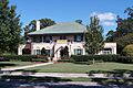
College View Historic District
-
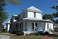
Cox-Ange House
-
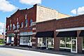
Dickinson Avenue Historic District
-
E. B. Ficklen House
-
James L. Fleming House
-
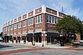
Greenville Commercial Historic District
-
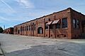
Greenville Tobacco Warehouse Historic District
-
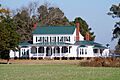
Grimesland Plantation
-
Robert Lee Humber House
-
Jones-Lee House
-
William J. Long House
-
Jesse R. Moye House
-
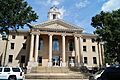
Pitt County Courthouse
-
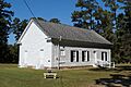
Red Banks Primitive Baptist Church
-
Skinnerville-Greenville Heights Historic District
-
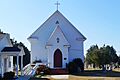
St. John's Episcopal Church
-
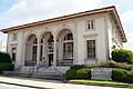
U.S. Post Office


.JPG)
