
National Register of Historic Places listings in Ravalli County, Montana facts for kids

This article is about the cool and historic places in Ravalli County, Montana, that are listed on the National Register of Historic Places. This special list helps protect important buildings, sites, and objects across the United States. It's like a hall of fame for places that tell a story about our past!
Ravalli County has many amazing places on this list, showing its rich history. There are 90 properties and areas in the county that are recognized as historically important. Let's explore some of them!
Contents
Historic Homes and Buildings
Many old houses and buildings in Ravalli County have been saved because they are so special. They show us how people lived and worked a long time ago.
Famous Houses in Hamilton
Hamilton has several homes on the National Register.
- The Allison-Reinkeh House at 207 Adirondac Street was listed in 1988.
- The Daniel V. Bean House and the Oliver Blood House are also important homes in Hamilton.
- The Conway House and the Foye Rental Houses are other examples of historic homes in the area.
- The Charles Granke House and the Charles Hoffman House also tell stories of early Hamilton residents.
- The John Lagerquist House and the McGlauflin House are more examples of historic homes.
- The John Stout House and the Erick Trosdahl House are also recognized.
- The Frank Wallin House and the Other C. Wamsley House add to Hamilton's historic charm.
Stevensville's Special Spots
Stevensville is home to many historic buildings, too.
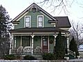
- The Bass Mansion at 216 North College Street is a grand old house listed in 1978.
- The Charles Amos Buck House and the Fred Buck House are two historic homes on Buck Street.
- The W.T. Caple House and the Jennie Clark House are also part of Stevensville's history.
- The William Cochran House and the Wilbur Cook House are found on the East Side Highway.
- The Calvin and Maggie Cook House is another interesting home on Main Street.
- The DeNayer House and the Emhoff House are also recognized.
- The Joseph Fisher House and the Perry Foust House are historic homes that show how people lived.
- The Charles Fulton House and the Gavin House are also on the list.
- The Rose Harrington House and the John G. Howe House are more examples of Stevensville's past.
- The Lancaster House and the John A. Landram House are also important.
- The Lockridge House and the Albert May House are recognized for their history.
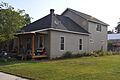
- The Charles May House, George May House, Harry May House, and Louis May House are all part of the May family's legacy in Stevensville.
- The McFarlane House and the John McLaughlin House are also on the list.
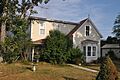
- The Metcalf House and the Philip and Ella Morr House are other historic homes.
- The John Sharp House and the Williams House are also important.
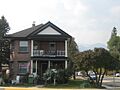
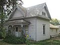
- The John and Ann Williams House and the Benjamin Young House complete this list of historic homes in Stevensville.
Important Public Buildings and Sites
Beyond homes, Ravalli County has other significant places that are part of its history.
Hamilton's Public Buildings
- The Marcus Daly Memorial Hospital in Hamilton, listed in 1978, is an important building that served the community for many years.
- The Hamilton Town Hall is another historic building in Hamilton, recognized in 1980. It was a central place for local government.
- The Ravalli County Courthouse is a grand building in Hamilton, listed in 1979. It's where many important decisions for the county have been made.
- The Rocky Mountain Laboratory Historic District is a special area in Hamilton. It includes buildings from a famous research lab that studied diseases. It was listed in 1988.
Stevensville's Community Places
- The Bitter Root Cooperative Creamery in Stevensville, listed in 1991, shows the importance of farming and dairy in the area's past.
- The Etna School, listed in 1997, was an important place for education in the community.
- The First Baptist Church in Stevensville, listed in 1991, is a historic place of worship.
- The First State Bank, Dowling and Emhoff Buildings are historic commercial buildings in Stevensville, listed in 1991. They show how businesses operated long ago.
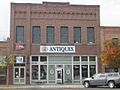
- The Gleason Building is another historic commercial building in Stevensville.
- The IOOF Hall (Independent Order of Odd Fellows Hall) in Stevensville, listed in 1991, was a meeting place for a community group.
- The Stevensville Feed Mill, listed in 1991, was vital for local agriculture.
- The Stevensville Grade School-United Methodist Church is a building that served as both a school and a church.
- The Stevensville Mercantile Company Oil Storage Building was important for storing goods.
- The Thornton Hospital in Stevensville, listed in 1991, was a key healthcare facility.
Other Notable Sites
- The Alta Ranger Station, located south of Conner in the Bitterroot National Forest, was listed in 1974. Ranger stations are important for managing forests and protecting nature.
- The Big Creek Lake Site near Stevensville is a special archaeological site, listed in 1976. Its exact location is kept secret to protect it.
- The Brooks Hotel in Corvallis, listed in 1980, was a place where travelers could stay.
- The Canyon Creek Laboratory of the U.S. Public Health Service west of Hamilton, listed in 1970, was a significant research facility.
- The El Capitan Lodge on Lake Como, listed in 1990, is a historic lodge in the Bitterroot National Forest.
- The Hayward Lodge, also on Lake Como, was listed in 2015 and is now known as Wood's Cabin.
- The Lost Horse Fireman's Cabin near Darby, listed in 1989, was used by firefighters in the forest.
- The McCart Fire Lookout near Sula, listed in 1996, was used to spot forest fires.
- The Methodist Episcopal Church South in Corvallis, listed in 1997, is a historic church.
- The Popham Ranch in Corvallis, listed in 1989, is a historic farm.
- Riverside in Hamilton, listed in 1987, was once the home of Marcus Daly, a very important person in Montana's history.
- St. Mary's Church and Pharmacy in Stevensville, listed in 1970, is a very old and important mission site.
- The Summers-Quast Farmstead in Corvallis, listed in 1997, is another historic farm.
- The University Heights Historic District near Darby, listed in 2012, is a historic neighborhood.
- The VFW Club in Hamilton, listed in 1988, was a meeting place for veterans.
- The Whaley Homestead near Stevensville, listed in 1992, is a historic farm within the Lee Metcalf National Wildlife Refuge.
Historic Districts
Some areas are so full of historic buildings that the whole neighborhood is listed as a "historic district."
- The Hamilton Commercial Historic District includes Main Street and other streets in Hamilton. It was listed in 1988 and shows what the town's business center looked like long ago.
- The Hamilton Southside Residential Historic District covers several streets in Hamilton, listed in 1988. It's a neighborhood with many old homes that show how people lived.
Images for kids
-
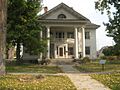
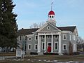
The historic Bass Mansion in Stevensville.
-
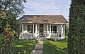
The Charles Amos Buck House in Stevensville.
-
The Fred Buck House in Stevensville.
-
The Calvin and Maggie Cook House in Stevensville.
-
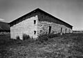
Barracks at Fort Owen, a very old site near Stevensville.
-
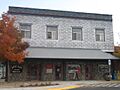
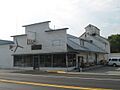
The Gleason Building in Stevensville.
-
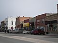
Main Street in Hamilton, part of the Commercial Historic District.
-
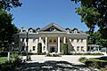
Riverside, the former home of Marcus Daly in Hamilton.
-
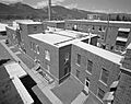
Building 4 at the Rocky Mountain Laboratory in Hamilton.
-
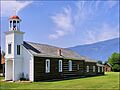
St. Mary's Mission Chapel in Stevensville.
-
The Stevensville Feed Mill.
-
The United Methodist Church in Stevensville, which was also a grade school.
-
The Albert May House in Stevensville.
-
The IOOF Hall in Stevensville.
-
The Philip and Ella Morr House in Stevensville.
-
The Benjamin Young House in Stevensville.


