
National Register of Historic Places listings in Routt County, Colorado facts for kids

Have you ever wondered about the old buildings and places in your town? Some of them are super special because they tell stories about the past! In Routt County, Colorado, there's a list of these amazing places called the National Register of Historic Places. This list helps protect buildings, sites, and objects that are important to American history.
There are 26 different places in Routt County that are on this special list. They include old cafes, schools, ranches, and even a theater school! One place used to be on the list but isn't anymore. Let's explore some of these cool historic spots!
Contents
What is the National Register of Historic Places?
The National Register of Historic Places is like a hall of fame for important places in the United States. It's run by the National Park Service. When a place is added to this list, it means it has a special story or design that's worth remembering and protecting. This helps make sure these places can be enjoyed by people for many years to come.
Why are places added to the list?
Places get on the National Register for a few reasons:
- History: They might be where important events happened.
- People: They could be linked to famous or important people.
- Design: They might have unique or beautiful architecture.
- Information: They might hold clues about how people lived long ago.
Historic Places in Routt County
Routt County is full of history, from its early ranching days to the growth of towns like Steamboat Springs. The places on the National Register show us different parts of this history.
Old Buildings in Yampa and Oak Creek
The towns of Yampa and Oak Creek have some neat old buildings.
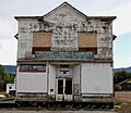
- The Antlers Cafe and Bar in Yampa (built around 1905) was a popular spot for people to eat and gather. It shows what early town life was like.
- Also in Yampa, the Bell and Canant Mercantile-Crossan's M and A Market was a general store. Imagine buying everything you needed there, from food to tools!
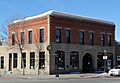
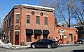
- In Oak Creek, the Bell Mercantile (built in 1909) was another important store. These stores were the heart of small towns.
Steamboat Springs' Historic Spots
Steamboat Springs has many buildings on the list, showing its growth as a town and a ski destination.
- The Chamber of Commerce Building (built in 1922) helped promote the town and its businesses.
- The Christian Science Society Building (built in 1934) is an example of unique architecture from that time.
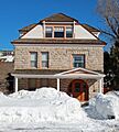
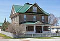
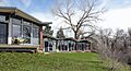
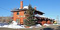
- The Crawford House (built in 1910) was a home that shows how people lived in Steamboat Springs over a hundred years ago.
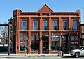
- The First National Bank Building (built in 1909) and the Routt County National Bank Building (built in 1905) were important for the town's money and business.
- The Maxwell Building (built in 1909) was another key business spot in downtown Steamboat.
- The Steamboat Apartments (built in 1948) show how housing developed after World War II.
- The Steamboat Laundry Building (built in 1910) was where people got their clothes cleaned, a vital service in the early days.
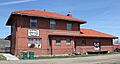
- The Steamboat Springs Depot (built in 1909) was the train station. Trains were super important for bringing people and goods to town before cars were common.
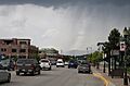
- The Steamboat Springs Downtown Historic District includes a whole area of Lincoln Avenue. This means many buildings together tell a story about the town's main street.
Historic Schools and Ranches
Education and ranching were big parts of Routt County's past.
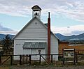
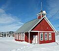
- The Foidel Canyon School (built in 1922) near Oak Creek was a small, one-room schoolhouse. Imagine all the kids learning together in one room!
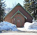
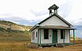
- The Hahns Peak Schoolhouse (built in 1912) in Hahns Peak Village is another example of an early school.
- The Mesa Schoolhouse (built in 1921) near Steamboat Springs also served local children. These schools were often the center of their communities.
- The Dawson-Carpenter Ranch (established in 1883) near Hayden shows the history of ranching in the area.
- The Kimsey-Bolten Ranch Rural Historic Landscape (dating back to 1900) near Hayden is another example of a historic ranch. These places show how people worked the land.
Other Interesting Places
Routt County has a variety of other historic sites:
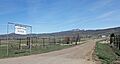
- The Columbine (built in 1900) near Clark is a historic district, meaning it's a group of buildings that are important together.
- The Hayden Co-Operative Elevator Company (built in 1917) in Hayden was where farmers stored their grain. It was a big part of the farming economy.
- The Hayden Depot (built in 1918) was Hayden's train station, just like the one in Steamboat Springs.
- The Hayden Rooming House (built in 1900) was a place where people could rent a room to stay, especially travelers or workers.
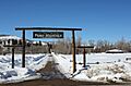
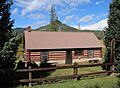
- The Perry-Mansfield School of Theatre and Dance (founded in 1913) in Steamboat Springs is a famous performing arts school. It's one of the oldest in the country!
- The Rock Creek Stage Station (built in 1880) near Toponas was a stop for stagecoaches, which were like old-time buses.
- The Solandt Memorial Hospital (built in 1927) in Hayden was an important place for health care in the community.
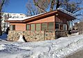
- The Summit Creek Ranger Station (built in 1908) near Columbine was used by forest rangers to manage the land.
What happened to the Four Mile Bridge?
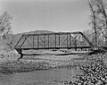
Sometimes, a place is removed from the National Register. This happened to the Four Mile Bridge near Steamboat Springs. It was a bridge over the Elk River, built in 1908. It was added to the list in 1985 but was removed in 1994 because it was replaced by a new bridge in 1989. This shows that sometimes, even historic structures need to be updated or replaced for safety or modern needs.
Images for kids
-

Antlers Cafe and Bar
-
Bell and Canant Mercantile-Crossan's M and A Market
-

Bell Mercantile
-
Chamber of Commerce Building
-
Christian Science Society Building
-

Columbine
-
Crawford House
-
Dawson-Carpenter Ranch
-
First National Bank Building
-
Foidel Canyon School
-
Hahns Peak Schoolhouse
-
Hayden Depot
-
Hayden Rooming House
-
Maxwell Building
-
Mesa Schoolhouse
-
Perry-Mansfield School of Theatre and Dance
-
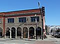
Routt County National Bank Building
-

Solandt Memorial Hospital
-
Steamboat Apartments
-
Steamboat Laundry Building
-
Steamboat Springs Depot
-
Steamboat Springs Downtown Historic District
-
Summit Creek Ranger Station
-
Four Mile Bridge (former listing)


.JPG)


.jpg)
