
National Register of Historic Places listings in Salt Lake City facts for kids
You've asked me to rewrite the provided MediaWiki text for children aged 12-15, adhering strictly to MediaWiki syntax and specific content and formatting guidelines.
Here's the rewritten text:

Hey there! Did you know that many buildings, parks, and other places in Salt Lake City, Utah are super old and important? They're so special that they've been added to a list called the National Register of Historic Places. Think of it like a Hall of Fame for historic spots across the United States!
This list helps protect these amazing places so that people can learn about their history for many years to come. In Salt Lake City, there are over 200 places on this list, including some that are even more famous, called National Historic Landmarks. Let's explore some of these cool historic sites!
Contents
- Cool Historic Places to See
- Famous Homes and Buildings
- Beehive House
- Simon Bamberger House
- Thomas Kearns Mansion
- Alfred W. McCune Mansion
- Brigham Young Complex
- Salt Lake City and County Building
- Utah State Capitol
- Cathedral of the Madeleine
- St. Mark's Episcopal Cathedral
- Holy Trinity Greek Orthodox Church
- Japanese Church of Christ
- First Church of Christ, Scientist
- Immanuel Baptist Church
- Trinity A.M.E. Church
- Old Clock at Zion's First National Bank
- Parks and Public Spaces
- Transportation and Industry Landmarks
- Famous Homes and Buildings
- Historic Districts
- Places No Longer on the List
- Images for kids
Cool Historic Places to See
Salt Lake City is full of awesome historic buildings and areas. Here are just a few examples of places that are on the National Register of Historic Places:
Famous Homes and Buildings
Beehive House

The Beehive House is a really famous home in downtown Salt Lake City. It was built way back in 1854 and was the main home of Brigham Young, who was an important leader in Utah's early history. It's called the "Beehive House" because of a beehive statue on top, which is a symbol of hard work.
Simon Bamberger House

This house belonged to Simon Bamberger, who was the governor of Utah from 1917 to 1921. It's a beautiful old home that shows how important people lived a long time ago.
Thomas Kearns Mansion

The Thomas Kearns Mansion is a grand house that was built in 1902. Today, it's where the governor of Utah lives! It's a great example of fancy homes from the past.
Alfred W. McCune Mansion

Another amazing mansion is the Alfred McCune Home. It was built in 1901 and is known for its beautiful design. It's a true architectural treasure in the city.
Brigham Young Complex

This complex includes several buildings connected to Brigham Young, like the Beehive House and the Lion House. These buildings show how the early leaders of Salt Lake City lived and worked.
Salt Lake City and County Building

The Salt Lake City and County Building is a huge, impressive building that was finished in 1894. It's still used today for city and county government offices. It looks like a castle and is a great example of old architecture.
Utah State Capitol

The Utah State Capitol building is where Utah's laws are made. It sits on a hill and has a fantastic view of the city. It's a very important building for the state.
Cathedral of the Madeleine

The Cathedral of the Madeleine is a stunning church built in the early 1900s. Its beautiful stained glass and detailed architecture make it a must-see.
St. Mark's Episcopal Cathedral

Another historic church, St. Mark's Episcopal Cathedral, was built in 1874. It's one of the oldest churches in Salt Lake City and has a lot of history.
Holy Trinity Greek Orthodox Church

The Holy Trinity Greek Orthodox Church was built in 1923 and is a beautiful example of Greek Orthodox architecture in Utah.
Japanese Church of Christ

This church, built in 1924, is an important part of Salt Lake City's Japanese-American history. It served as a community center for many years.
First Church of Christ, Scientist

Built in 1921, this church is known for its unique architectural style and has been a place of worship for many years.
Immanuel Baptist Church

The Immanuel Baptist Church was built in 1910 and is a historic landmark for its role in the community and its design.
Trinity A.M.E. Church

The Trinity A.M.E. Church was built in 1907 and is an important part of the African American history in Salt Lake City.
Old Clock at Zion's First National Bank

This isn't a building, but a cool old clock! It's located on the corner of 100 South and Main Street and has been a landmark for many years.
Parks and Public Spaces
Liberty Park

Liberty Park is one of Salt Lake City's largest and oldest parks. It's a great place to relax, play, and enjoy nature. The park also includes the historic Isaac Chase Mill.
Isaac Chase Mill

Located in Liberty Park, the Isaac Chase Mill was built in 1852. It's one of the oldest buildings in Utah and was used to grind grain for the early settlers.
Temple Square

Temple Square is a very famous spot in Salt Lake City. It's home to the Salt Lake Temple and other important buildings of The Church of Jesus Christ of Latter-day Saints. It's a beautiful and peaceful place to visit.
Old Pioneer Fort Site

This site marks where the first pioneers built a fort when they arrived in Salt Lake Valley in 1847. It's a reminder of the city's beginnings.
Utah State Fair Grounds

The Utah State Fair Grounds have been hosting the annual Utah State Fair since 1902. It's a place where people gather for fun, food, and entertainment every year.
Transportation and Industry Landmarks
Denver and Rio Grande Railroad Station

The Denver and Rio Grande Railroad Station was built in 1910. It was a busy train station that helped connect Salt Lake City to the rest of the country.
Salt Lake Union Pacific Railroad Station

Another important train station, the Salt Lake Union Pacific Railroad Station, was built in 1909. These stations were key to the city's growth and trade.
Z.C.M.I. Cast Iron Front

The Z.C.M.I. Cast Iron Front is a unique part of a historic department store building. It's famous for its beautiful cast-iron design, which was very modern for its time in the 1870s.
Sweet Candy Company Building

This building was home to the Sweet Candy Company, a famous candy maker. It's a sweet reminder of Salt Lake City's industrial past.
Western Macaroni Manufacturing Company Factory

This factory, built in 1923, shows Salt Lake City's history in food production. It's cool to think about all the macaroni that was made here!
Historic Districts
Sometimes, it's not just one building that's historic, but a whole neighborhood! These are called Historic Districts.
The Avenues Historic District

The Avenues is one of Salt Lake City's oldest neighborhoods. It has many beautiful historic homes and streets that show how the city grew.
Capitol Hill Historic District

This area around the State Capitol building has many historic homes and buildings, showing the city's early development and important government presence.
South Temple Historic District

This district includes many grand homes and buildings along South Temple Street, showing the wealth and style of early Salt Lake City.
University Neighborhood Historic District
This area near the University of Utah has many historic homes and buildings that grew up around the university campus.
Yalecrest Historic District

Yalecrest is a neighborhood known for its unique and well-preserved homes from the early 20th century. It's a great example of historic residential architecture.
Places No Longer on the List
Sometimes, a place might be removed from the National Register of Historic Places. This can happen if a building is moved to a new location, or if it's changed too much, or even if it's torn down.
For example, the Brigham Young Forest Farmhouse was delisted because it was moved to This Is the Place Heritage Park. Also, the Utah State Liquor Agency No. 22 building is no longer there, as it was demolished.
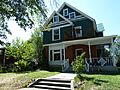
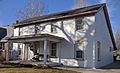
Images for kids
-
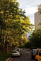
City Creek Canyon
-
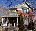
The Harper J. Dininny House
-
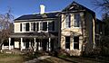
The Keyser-Cullen House
-
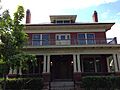
The Joseph and Marie N. McRae House
-
The Alexander Mitchell House
-
The Wilford Woodruff Farm House


