
National Register of Historic Places listings in Schenectady County, New York facts for kids

Welcome to Schenectady County, New York! Did you know that many buildings and places here are super old and important? They are so special that they are listed on something called the National Register of Historic Places. This list helps protect amazing historical spots all across the United States.
When a place is on this list, it means it has a cool story to tell about American history, architecture, or even how people lived long ago. In Schenectady County, you can find all sorts of historic places, from old farmhouses to grand theaters and even parts of famous canals! Some of these places are so important that they are called National Historic Landmarks, which is an even higher honor!
Contents
What is the National Register of Historic Places?
The National Register of Historic Places is like a special club for buildings, sites, objects, and districts that are important to the history of the United States. It's managed by the National Park Service, which is part of the U.S. government.
Why are places listed?
Places get listed for many reasons. Maybe they are:
- Very old and show how people built things a long time ago.
- Connected to important events in history.
- Homes or workplaces of famous people.
- Great examples of a certain style of architecture.
- Important for understanding local culture or traditions.
Being on the list helps people learn about these places and makes sure they are taken care of for future generations.
Exploring Schenectady County's Historic Treasures
Schenectady County is full of fascinating historic sites. Let's take a look at some of the cool places you can find here!
Super Important Landmarks
Some places in Schenectady County are so special they've been named National Historic Landmarks. This means they are important to the history of the entire country!
General Electric Research Laboratory

The General Electric Research Laboratory in Schenectady is a really big deal! It was the very first research lab ever created by an American company. Imagine a place where brilliant scientists and inventors worked together to discover new things. This lab helped create many of the technologies we use today. It was added to the list in 1975.
Irving Langmuir House

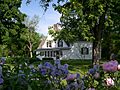
The Irving Langmuir House was the home of a super smart scientist named Irving Langmuir. He won the Nobel Prize in Chemistry in 1932! While working at General Electric, he made light bulbs better, helped us understand atoms, and even worked on how to make clouds produce rain. His house became a landmark in 1976.
Nott Memorial Hall

On the Union College campus in Schenectady, you'll find the amazing Nott Memorial Hall. This building is shaped like a 16-sided dome and looks like something out of a fairy tale! It's a fantastic example of Victorian Gothic architecture, which was popular a long time ago. It was built in the 1800s and has been used for many different things over the years. It was fully fixed up in the 1990s and became a landmark in 1972.
New York State Canal System
The New York State Canal System is a huge network of waterways that runs right through Schenectady County. This canal system was built in the early 1900s to help boats move goods across New York State, competing with railroads. It's a successor to the famous Erie Canal. This entire system was recognized as a National Historic Landmark District in 2014.
Historic Buildings and Homes
Schenectady County has many old buildings that tell stories about the past.
H. S. Barney Building
The H. S. Barney Building at 217-229 State Street in Schenectady was listed in 1984. It's an important part of the city's downtown history.
Foster Building

The Foster Building at 508 State Street in Schenectady is special because it was the first building in the city to use terra-cotta, a type of baked clay used for decoration. It was built in 1907 and also showed the influence of the City Beautiful movement, which aimed to make cities more beautiful and organized. It was added to the list in 1991.
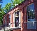
Abraham Glen House

The Abraham Glen House in Scotia is a very rare and old Dutch-style house, built way back in the 1730s! It has a special "heavy timber frame" construction. Today, this historic house is used as Scotia's branch of the county public library, which is a cool way to keep history alive! It was listed in 2004.
Hotel Van Curler (Elston Hall)

The Hotel Van Curler was built in 1925 and is now called Elston Hall, part of the Schenectady County Community College. It's a grand building that has seen many changes over the years. It was added to the list in 1985.
Mabee House

The Mabee House is located south of Rotterdam Junction. This old house was listed in 1978 and is a great example of early homes in the area.
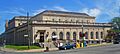
Proctor's Theatre

Proctor's Theatre at 432 State Street in Schenectady is a magnificent theater built in 1926. It was one of the most fancy theaters in the country when it first opened! Guess what? It even hosted the very first public demonstration of television in 1930! Imagine seeing TV for the first time there! It was listed in 1979 and has been beautifully restored.
Schenectady Armory

The Schenectady Armory at 125 Washington Avenue is a cool Art Deco style building from 1936. It's unusual because it was built right in the middle of the city, not on the outskirts like many armories. It was listed in 1995.
Schenectady City Hall and Post Office

The Schenectady City Hall and Post Office building on Jay Street was built in 1931. It was designed by a famous architecture firm, McKim, Mead and White. The building has cool window arches that match the nearby post office. It was listed in 1978.
U.S. Post Office - Schenectady

The U.S. Post Office-Schenectady at 29 Jay Street is a neoclassical building from 1912. It was made even bigger during the Great Depression. It was listed in 1989.
U.S. Post Office - Scotia Station

The U.S. Post Office-Scotia Station at 224 Mohawk Avenue in Scotia is a detailed Colonial Revival style building. It was built between 1939 and 1940 and was listed in 1989.
Young Men's Christian Association of Schenectady
The Young Men's Christian Association of Schenectady building at 9–13 State Street was built in 1928. This building is part of a time when YMCAs were growing rapidly across the country. It was listed in 2015.
Historic Districts
Sometimes, it's not just one building that's historic, but a whole group of buildings or an entire neighborhood! These are called "historic districts."
Delanson Historic District
The Delanson Historic District on Main Street in Delanson was recognized in 1984. This area shows what a historic village looked like.
Eatons Corners Historic District
The Eatons Corners Historic District on Eatons Corners Road in Duanesburg was listed in 1984. It's a collection of historic buildings that show the history of this crossroads community.
General Electric Realty Plot

The General Electric Realty Plot in Schenectady is a special neighborhood. It was once land owned by Union College, but in the late 1800s, GE bought it. They wanted their top executives and researchers to build fancy homes there. It's roughly bounded by Oxford Place, Union Avenue, Nott Street, and Lenox and Lowell Roads. This district was listed in 1980.
Mariaville Historic District
The Mariaville Historic District on NY 159 in Duanesburg was listed in 1984. This district helps preserve the historic character of the Mariaville area.
Quaker Street Historic District

The Quaker Street Historic District in Duanesburg, located around Schoharie Turnpike, Gallupville, and Darby Hill Roads, was listed in 1984. This district includes buildings that show the history of the Quaker community in the area.
Stockade Historic District

The Stockade Historic District in Schenectady is the oldest part of the city! Many of the houses here date back to the 1700s. It's roughly bounded by the Mohawk River, railroad tracks, and Union Street. This district was listed in 1973 and is a fantastic place to see very old American homes.
Union Street Historic District

The Union Street Historic District in Schenectady stretches along Union Street from the Hudson River to Phoenix Avenue. This area shows how the city grew in the 1800s. It has many well-preserved buildings from that time and was listed in 1982.
Old Farmhouses and Rural Sites
Schenectady County also has many historic farmhouses and rural properties that show what life was like for farmers long ago. Many of these were listed in 1984 as part of a special project to recognize historic farms in the area.
- Abrahams Farmhouse (Duanesburg)
- Avery Farmhouse (Duanesburg)
- Becker Farmhouse (Duanesburg)
- Chadwick Farmhouse (Duanesburg)
- Chapman Farmhouse (Duanesburg)
- Dellemont-Wemple Farm (Rotterdam) - Listed in 1973.
- Ferguson Farm Complex (Duanesburg) - Listed in 1987.
- Gaige Homestead (Duanesburg)
- Gilbert Farmhouse (Duanesburg)
- Joseph Green Farmhouse (Duanesburg)
- Halladay Farmhouse (Duanesburg)
- Hawes Homestead (Duanesburg)
- Howard Homestead (Duanesburg)
- Ladd Farmhouse (Duanesburg)
- George Lasher House (Duanesburg)
- Alexander Liddle Farmhouse (Duanesburg)
- Robert Liddle Farmhouse (Duanesburg)
- Thomas Liddle Farm Complex (Duanesburg)
- Macomber Stone House (Duanesburg)
- Sheldon Farmhouse (Duanesburg)
- Joseph Wing Farm Complex (Duanesburg)
- William R. Wing Farm Complex (Duanesburg)
Churches and Schools
Many historic churches and schools are also found in Schenectady County, showing the importance of community and education over the centuries.
- Brandywine Avenue School (Schenectady) - Sadly, this school was destroyed by fire in 2007, but it was listed in 1999.
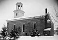
- Christ Episcopal Church (Duanesburg) - This beautiful church was listed in 1987.
- Duanesburg-Florida Baptist Church (Duanesburg) - Listed in 1984.
- First Unitarian Society Church (Schenectady) - This church, built in 2014, is a modern style building designed by Edward Durell Stone. It's located in the GE Realty Plot district.
- Franklin School (Schenectady) - Listed in 1983.
- Glenville District No. 5 Schoolhouse (Glenville) - This old schoolhouse was listed in 2014.
- Horace Mann School (Schenectady) - Built in 1908 to handle more students in a growing neighborhood, this school was listed in 2015.
- Niskayuna Reformed Church (Niskayuna) - This church was listed in 1979.
- Nott Street School (Schenectady) - Listed in 2011.
- Reformed Presbyterian Church Parsonage (Duanesburg) - This parsonage (a home for a church minister) was listed in 1984.
- Rosendale Common School (Niskayuna vicinity) - Listed in 2010.
- St. Columba's School (Schenectady) - This school, built in 1923, was very important to the Irish Catholic community in the city. It was listed in 2015.

Other Interesting Sites
There are also unique and important sites that don't fit neatly into other categories.
- Bishop Family Lustron House (Glenville) - This house, listed in 2008, is a special type of prefabricated home made of steel, called a Lustron House.
- Central Fire Station (Schenectady) - The city's main fire station was listed in 1985.
- Christman Bird and Wildlife Sanctuary (Delanson) - This sanctuary, important for nature and wildlife, was listed in 1970.
- Enlarged Double Lock No. 23, Old Erie Canal (Rotterdam) - This old canal lock was part of the historic Erie Canal system and was listed in 2008.
- Jenkins Octagon House (Duanesburg) - This house, listed in 1984, has a very unusual eight-sided shape!
- Niskayuna Railroad Station (Niskayuna) - This old train station was listed in 2007.
- Shute Octagon House (Duanesburg) - Another unique eight-sided house, listed in 1984.
- Vale Cemetery and Vale Park (Schenectady) - This historic cemetery and park combination was listed in 2004.


These are just some of the many amazing historic places in Schenectady County! Each one has a unique story that helps us understand the rich history of this area and the people who lived here.
Images for kids
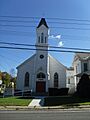
-
Christ Episcopal Church in Duanesburg.
-
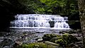
A waterfall at Christman Bird and Wildlife Sanctuary.
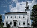
-
Delanson Methodist Church in the Delanson Historic District.
-
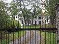
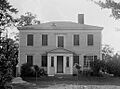
The historic Duane Mansion.
-
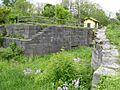
Lock No. 23 of the Old Erie Canal.
-
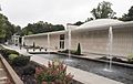
First Unitarian Society Church.
-
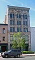
The Foster Building.
-
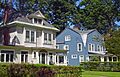
Homes in the General Electric Realty Plot.
-
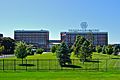
The General Electric Research Laboratory in Schenectady.
-
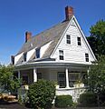
The Abraham Glen House, a very old Dutch-style home.
-
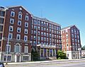
The former Hotel Van Curler, now Elston Hall.
-

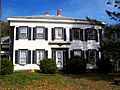
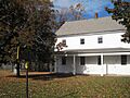
The Jenkins House in Delanson.
-
The unique Jenkins Octagon House.
-
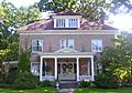
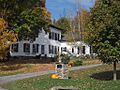
The A.D. (Boss) Jones House.
-
The home of Nobel Prize winner Irving Langmuir.
-
The historic Mabee House in Rotterdam Junction.
-
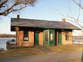
The Niskayuna Railroad Station.
-
The Niskayuna Reformed Church.
-
The North Mansion.
-
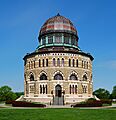
The unique 16-sided Nott Memorial Hall at Union College.
-
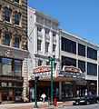
The grand Proctor's Theatre in Schenectady.
-
The Quaker Meeting House in the Quaker Street Historic District.
-
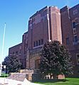
The Schenectady Armory, an Art Deco building.
-

Schenectady City Hall.
-
The Shute Octagon House.
-
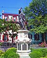
A statue in the Stockade Historic District.
-
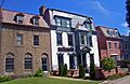
Historic homes along Union Street.
-
The U.S. Post Office in Schenectady.
-
The U.S. Post Office in Scotia.
-
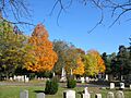
Vale Cemetery in the fall.


,_Niskayuna_(Schenectady_County,_New_York).jpg)
.jpg)
