
National Register of Historic Places listings in Taylor County, Kentucky facts for kids

Hey everyone! Did you know that some places are so special and important that they get listed on a special list? This list is called the National Register of Historic Places. It's like a hall of fame for buildings, battlefields, and other cool spots that tell us about the past.
In Taylor County, Kentucky, there are 14 different places that are on this important list. These places help us remember and learn about the history of our area and the whole United States. Let's explore some of these amazing historic sites!
Contents
- What is the National Register of Historic Places?
- Historic Places in Taylor County
- Battle of Tebb's Bend Monument
- Battle of Tebbs Bend
- James Caldwell House
- Campbellsville Historic Commercial District
- Campbellsville Residential Historic District
- Campbellsville School, Stadium and Athletic Field
- John Chandler House
- Clay Hill
- Jonathan Cowherd Jr. House
- Jacob Hiestand House
- Merchant's Hotel
- Durham Sanders House
- Isaac Tate Farm
- Taylor County Clerk's Office
- Images for kids
What is the National Register of Historic Places?
The National Register of Historic Places is the official list of the nation's historic places that are worth saving. It's managed by the National Park Service. When a place is added to this list, it means it's recognized for its history, architecture, or even what happened there.
Being on the National Register helps protect these places. It also encourages people to learn about them and keep them safe for future generations. It's a way to celebrate the stories and events that shaped our country.
Historic Places in Taylor County
Taylor County has a rich history, and many of its important sites are recognized on the National Register. Here are some of the cool places you can find:
Battle of Tebb's Bend Monument
This monument remembers a brave battle that happened during the American Civil War. In 1863, a small group of Union soldiers fought off a much larger Confederate force here. It's a reminder of the courage shown during that time.
Battle of Tebbs Bend
This is the actual battlefield where the Battle of Tebb's Bend took place. It's a large area that helps us understand how the battle unfolded. Walking here can make you feel like you're stepping back in time.
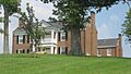
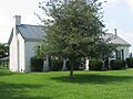
James Caldwell House
The James Caldwell House is an old home in Campbellsville. It's a great example of the kind of houses people lived in long ago. It shows us how architecture has changed over the years.
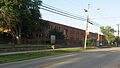
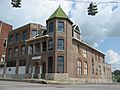
Campbellsville Historic Commercial District
This district includes many of the old shops and businesses in downtown Campbellsville. Imagine what it was like when people came here to buy their goods and meet friends. These buildings tell the story of how the town grew.
Campbellsville Residential Historic District
This area is full of historic homes where families have lived for many years. It shows us the different styles of houses that were popular in the past. It's a nice place to take a walk and admire the older buildings.
Campbellsville School, Stadium and Athletic Field
This site includes an old school building, a stadium, and an athletic field. It reminds us of how important education and sports have always been to the community. Many students have learned and played here over the decades.
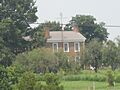
John Chandler House
The John Chandler House is another historic home in Taylor County. It's a piece of the past that has been preserved. It helps us understand the lives of early settlers and families in the area.
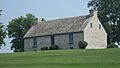
Clay Hill
Clay Hill is a historic property located north of Campbellsville. It's an important landmark that has been around for a long time. It represents the rural history and farming traditions of the county.
Jonathan Cowherd Jr. House
This house, west of Campbellsville, is another example of the historic homes in the county. It's named after Jonathan Cowherd Jr., who was likely an important person in the area's early days.
Jacob Hiestand House
The Jacob Hiestand House is also located west of Campbellsville. Like other historic homes, it offers a glimpse into the past. These houses are like living museums, showing us how people lived.
Merchant's Hotel
The Merchant's Hotel was once a busy place where travelers could stay. It's located on Main Street in Campbellsville. Hotels like this were very important before cars were common, as they offered a place to rest during long journeys.
Durham Sanders House
The Durham Sanders House is another historic home that has been recognized for its importance. It's a beautiful example of older architecture and helps tell the story of the families who lived there.
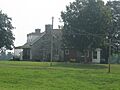
Isaac Tate Farm
The Isaac Tate Farm is a historic farm south of Campbellsville. Farms like this were the backbone of the community for many years. It shows us the agricultural history of Taylor County and how people worked the land.
Taylor County Clerk's Office
Located on Courthouse Square, the Taylor County Clerk's Office is a very important building. This is where many official records are kept, like birth certificates and property deeds. It's been a center for local government for a long time.
Images for kids
-
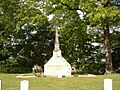
The Battle of Tebb's Bend Monument
-
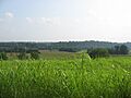
The historic Tebbs Bend Battlefield
-
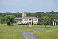
The James Caldwell House
-
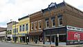
A building in the Campbellsville Historic Commercial District
-
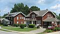
High Street in the Campbellsville Residential Historic District
-
The old Campbellsville School building
-
The historic John Chandler House
-
Clay Hill, a historic property
-
The Jonathan Cowherd, Jr., House
-
The Jacob Hiestand House
-
The Merchant's Hotel building
-
The Durham Sanders House
-
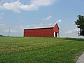
A barn at the Isaac Tate Farm
-
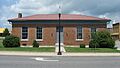
The front of the Taylor County Clerk's Office


