
National Register of Historic Places listings in Teller County, Colorado facts for kids

Welcome to Teller County, Colorado! This area is home to many special places that are listed on the National Register of Historic Places. This is a list kept by the United States government to recognize buildings, sites, and objects that are important in American history, architecture, archaeology, engineering, and culture. When a place is on this list, it means it's worth protecting and learning about for future generations.
Teller County has 10 places on this important list. One of them is even a National Historic Landmark, which means it's extra special and recognized across the whole country! These places help us understand what life was like in Colorado's past, especially during the exciting gold rush days.
Historic Places in Teller County
Cripple Creek Historic District

The Cripple Creek Historic District is a very important area along State Highway 67. It was added to the National Register in 1966 and is also a National Historic Landmark. This district includes much of the historic mining town of Cripple Creek. It shows what a bustling gold mining town looked like in the late 1800s and early 1900s. Many of the buildings here are still standing and tell stories of the gold rush era.
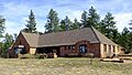
Florissant School

The Florissant School, located at 2009 County Road 31 in Florissant, was listed in 1990. This old school building is a reminder of early education in Teller County. It shows how communities came together to provide schooling for children in the past. Today, it helps us understand the history of learning in the area.
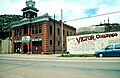
Goldfield City Hall and Fire Station

You can find the Goldfield City Hall and Fire Station at Victor Avenue and 9th Street in Goldfield. It was added to the National Register in 1984. These buildings were once the heart of the small mining town of Goldfield. They represent the local government and emergency services that were vital for mining communities during their boom times.
Hornbek House

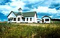
The Hornbek House, located on County Road 1 in Florissant, became a historic listing in 1981. This house belonged to a pioneer woman named Adeline Hornbek. It's a great example of a homestead from the late 1800s. It shows us what life was like for early settlers who moved to Colorado to start new lives and farms.
Manitou Experimental Forest Station

The Manitou Experimental Forest Station, at 232 County Road 79 in Woodland Park, was listed in 1998. This station is a special place where scientists study forests and how they grow. It's important for understanding nature and how to protect our trees and environment. It has been used for research for many years.
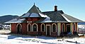
Midland Terminal Railroad Depot
.JPG)
The Midland Terminal Railroad Depot is located at 230 North 4th Street in Victor. It was added to the National Register in 1984. This old train station was a very busy place during the gold rush. Trains were essential for bringing supplies to the mining towns and taking gold out. This depot reminds us of the important role railroads played in Colorado's history.
Stratton's Independence Mine and Mill

You can find Stratton's Independence Mine and Mill at the junction of Rangeview Road and State Highway 67 in Victor. It was listed in 1993. This site was once a very successful gold mine owned by Winfield Scott Stratton. It shows the scale of gold mining operations and the technology used to extract gold from the earth.
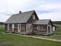
Twin Creek Ranch

Twin Creek Ranch, located at 1465 Teller County Road 31 in Florissant, was added to the list in 1997. This ranch is an example of the agricultural history of Teller County. It shows how people lived and worked on ranches in the area, raising animals and growing crops, which was another important part of Colorado's development.
Victor Downtown Historic District

The Victor Downtown Historic District is roughly bounded by Diamond Avenue, 2nd, Portland, and 5th Streets in Victor. It became a historic district in 1985. Like Cripple Creek, this district preserves the look and feel of a historic gold mining town. Walking through Victor's downtown is like stepping back in time to the days when gold miners filled the streets.
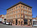
Victor Hotel

The Victor Hotel, located at 4th Street and Victor Avenue in Victor, was listed in 1980. This grand hotel was built during the height of the gold rush. It provided lodging for miners, businessmen, and visitors to the booming town of Victor. It's a beautiful example of the architecture from that time and shows the prosperity of the mining era.
Images for kids
-
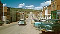
A view of Cripple Creek in 1957
-
The Florissant School building today
-
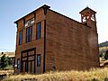
The Goldfield City Hall and Fire Station
-
The historic Hornbek House
-
The Manitou Experimental Forest Station
-
The old Midland Terminal Railroad Depot
-
Stratton's Independence Mine and Mill
-
The Twin Creek Ranch
-
Victor City Hall, part of the historic district
-
The historic Victor Hotel
