
National Register of Historic Places listings in Tioga County, New York facts for kids

Welcome to Tioga County, New York! Did you know that many buildings and places here are super old and important? They are so special that they are listed on something called the National Register of Historic Places. This list helps protect places that tell us about the past. It's like a hall of fame for historic buildings and areas across the United States!
When a place is on this list, it means it's been recognized for its special history, architecture, or what it means to the community. It could be an old house, a church, a school, or even a whole neighborhood! These places help us learn about how people lived long ago and what was important to them.
Contents
What is the National Register of Historic Places?
The National Register of Historic Places is the official list of the nation's historic places worth saving. It's managed by the National Park Service, which is part of the U.S. government. Being on the Register doesn't stop people from changing their property, but it does encourage them to preserve it. It also means these places might get special grants or tax benefits to help with their upkeep.
Why are places listed?
Places are listed for many reasons. Maybe they are:
- Very old and show how buildings were made a long time ago.
- Connected to important people or events in history.
- Great examples of a certain style of architecture.
- Important to the local community's story.
In Tioga County, you'll find all sorts of historic places, from old farmhouses to public buildings. Each one has a story to tell about the county's past.
Historic Homes and Farms
Many of the places on the National Register in Tioga County are old homes and farms. These buildings give us a peek into what life was like for families who lived here many years ago.
Berkshire's Old Houses
The town of Berkshire has several historic homes. For example, the Lyman P. Akins House and the Robert Akins House are both listed. These houses show us the styles of homes that were popular in the 1800s. The J. Ball House, Levi Ball House, and Stephen Ball House are also in Berkshire, showing how families often settled near each other.
The Belcher Family Homestead and Farm in Berkshire is another example. It reminds us of the farming history of the area. Farms like the Belcher-Holden Farm and Blewer Farm in Newark Valley also highlight the importance of agriculture in Tioga County's past.
Notable Residences in Owego
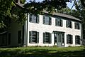
In the village of Owego, you can find the James C. Beecher House. This house is a beautiful example of historic architecture. Another interesting spot is Vesper Cliff, located outside the village of Owego. It's a historic estate that shows how some of the wealthier families lived.
Community Buildings and Public Spaces
Beyond homes, many important community buildings and public spaces in Tioga County are also listed. These places were central to people's lives.
Churches and Cemeteries
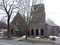
Churches often play a big role in a community's history. The East Berkshire United Methodist Church and the First Congregational Church in Berkshire are both historic places of worship. The First Methodist Episcopal Church of Tioga Center and the First Presbyterian Church in Spencer are also on the list, showing the long history of faith in the area.
Cemeteries are also important historical sites because they are the final resting places of early settlers and important community members. Evergreen Cemetery in Owego and Hope Cemetery and Mausoleum in Newark Valley are examples of these. The Glenwood Cemetery and Mausoleum in Waverly is a large hillside cemetery with a beautiful mausoleum built in 1923.
Schools and Government Buildings
Schools are places where generations learned and grew. The Waverly Junior and Senior High School is a listed building, showing its importance to education in the area.
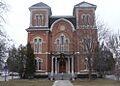
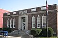
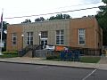
Government buildings are also key. The Tioga County Courthouse in Owego is a very important building where laws were made and justice was served. It was listed way back in 1972! The US Post Office-Owego and US Post Office-Waverly are also historic, reminding us of how important mail service was for connecting communities. The Newark Valley Municipal Building and Tappan-Spaulding Memorial Library serves as a hub for the community.
Other Important Structures
The Grand Army of the Republic Hall in Halsey Valley is a special place. It was a meeting hall for Civil War veterans, showing a piece of American military history. The Silk Street Bridge in Newark Valley is also listed, highlighting the importance of old bridges in connecting different parts of the county.
Historic Districts
Sometimes, it's not just one building that's historic, but a whole group of them! These are called historic districts.
The Berkshire Village Historic District includes many buildings along Main Street and Leonard Avenue in Berkshire. This means that the whole area has a special historic feel. The Owego Central Historic District is another example, covering many streets in the heart of Owego. Walking through these districts is like taking a step back in time!
Images for kids
-
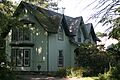
The James C. Beecher House in Owego.
-
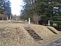
Evergreen Cemetery in Owego.
-
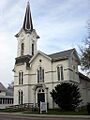
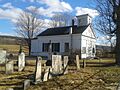
The First Methodist Episcopal Church of Tioga Center.
-

The First Presbyterian Church in Spencer.
-
The Grand Army of the Republic Hall in Halsey Valley.
-
Hiawatha Farm in Owego.
-
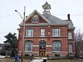
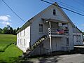
The Newark Valley Municipal Building.
-
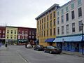
A view of the Owego Central Historic District.
-
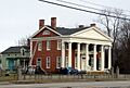
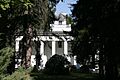
The Platt-Cady Mansion in Nichols.
-
St. Paul's Church in Owego.
-
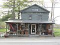
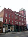
The Tioga Centre General Store.
-
The Tioga County Courthouse in Owego.
-
The U.S. Post Office in Owego.
-
The U.S. Post Office in Waverly.
-
Vesper Cliff near Owego.
-
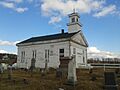
Waits Methodist Episcopal Church and Cemetery.
-
Waverly Village Hall.
-
West Newark Congregational Church and Cemetery.


