
National Register of Historic Places listings in Wakulla County, Florida facts for kids

Have you ever wondered about the cool old places in Wakulla County, Florida? This article will tell you about some of them! These special spots are listed on the National Register of Historic Places. This means they are important because of their history, amazing design, or what they teach us about the past.
Wakulla County has 10 places listed on this special register. One of them is even a National Historic Landmark, which is a super important historical site! Let's explore some of these fascinating places and learn why they are so special.
Contents
- What is the National Register of Historic Places?
- Discovering Wakulla County's Historic Treasures
- Images for kids
What is the National Register of Historic Places?
The National Register of Historic Places is like a special list kept by the United States government. It helps protect places that are important to American history and culture. When a place is on this list, it means it's worth saving for future generations to learn from and enjoy. It could be an old building, a historic park, or even an archaeological site.
Discovering Wakulla County's Historic Treasures
Wakulla County is full of interesting history, from ancient Native American sites to old forts and lighthouses. Each place tells a unique story about the people and events that shaped this part of Florida.
Fort San Marcos de Apalache: A Glimpse into the Past

One of the most important places in Wakulla County is San Marcos de Apalache Historic State Park, also known as Fort San Marcos de Apalache. This fort is a National Historic Landmark, which means it's one of the most important historical sites in the entire country! It's located near St. Marks.
Why was this fort important?
This fort has a long history, going back to the late 1600s. It was built by the Spanish to protect their land and trade routes. Over the years, it was controlled by different groups, including the Spanish, British, and even Native Americans. Imagine all the different people who walked through these grounds! Today, you can visit the park and see the remains of the fort, learning about its exciting past.
St. Marks Lighthouse: Guiding Ships for Years

Another famous landmark is the St. Marks Lighthouse. This tall, white lighthouse stands proudly on the northern side of Apalachee Bay. Lighthouses are like giant flashlights that help guide ships safely to shore, especially at night or in bad weather.
How old is the St. Marks Lighthouse?
The original lighthouse was built in the early 1800s, making it one of Florida's oldest lighthouses. It has stood strong through many storms and changes, continuing to serve as a beacon for sailors. It's a beautiful spot to visit and imagine the ships it has guided over the centuries.
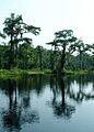
Wakulla Springs: A Natural and Historic Wonder

The Wakulla Springs Archeological and Historic District is a truly special place. Located at Edward Ball Wakulla Springs State Park, it's known for one of the largest and deepest freshwater springs in the world! But it's not just about nature; it also has a rich human history.
What makes Wakulla Springs historic?
People have lived around Wakulla Springs for thousands of years, making it an important archaeological site. Scientists have found ancient tools and bones here, showing how early people used the spring. In more recent times, the spring became famous for its beauty and was even used as a filming location for old movies! It's a wonderful place to explore nature and learn about the past.
Old Wakulla County Courthouse: A Center of Community

In Crawfordville, you can find the Old Wakulla County Courthouse. Courthouses are important buildings where laws are made and justice is served. This old building was once the heart of the county's government.
What happened at the Old Courthouse?
For many years, this courthouse was where important decisions were made for Wakulla County. People would come here for trials, to register land, and for other official business. It's a reminder of how communities organized themselves in the past and how important these buildings were to daily life.
Other Historic Places to Discover
Wakulla County has other interesting places on the National Register too:
- Bird Hammock: An ancient archaeological site that tells us about early Native American life.
- Bo Lynn's Grocery: An old store that was a central part of the community in St. Marks.
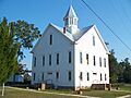
- Mount Beasor Primitive Baptist Church: A historic church building that shows the importance of faith in the community.
- Old Sopchoppy High School Gymnasium and Sopchoppy School: These buildings remind us of the history of education in the area and the importance of schools to a town.
Each of these places helps us understand the rich history of Wakulla County and why it's important to protect these treasures for everyone to enjoy and learn from.
Images for kids
-
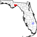
Location of Wakulla County in Florida
-
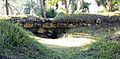
The old walls of Fort San Marcos de Apalache
-

The Old Sopchoppy High School Gymnasium
-
The historic Old Wakulla County Courthouse
-
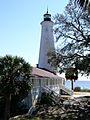
The beautiful St. Marks Lighthouse
-

The Sopchoppy School
-
The clear waters of Wakulla Springs


