
National Register of Historic Places listings in Webster County, Nebraska facts for kids

Have you ever wondered about the oldest and most important places in your state? In Webster County, Nebraska, there's a special list of places that are super important to history! This list is called the National Register of Historic Places. It's like a hall of fame for buildings, sites, and objects that tell us about the past. When a place is on this list, it means it's recognized by the United States government as worth protecting for future generations. Webster County has 36 of these amazing historic places, and two of them are even more special, called National Historic Landmarks!
These historic places include old homes, churches, businesses, and even natural areas. They help us understand what life was like long ago in Webster County. Many of these places are in the city of Red Cloud, Nebraska, which is famous for its connection to a well-known writer.
Contents
Special Historic Landmarks
Some places are so important that they get an extra special title: National Historic Landmarks. Webster County has two of these!
Willa Cather House
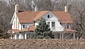
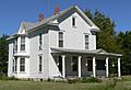
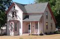
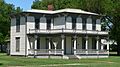
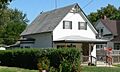
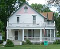
This house, located at the southwestern corner of 3rd Avenue and Cedar Street in Red Cloud, Nebraska, was home to the famous American writer Willa Cather. She wrote many stories about life on the Nebraska prairie. This house helps us remember her and the stories she told. It was added to the list on April 16, 1969.
Pike-Pawnee Village Site
This important historical site is near Guide Rock, Nebraska. It's where an old Pawnee village once stood. It's also famous because it's believed to be the place where explorer Zebulon Pike met with the Pawnee in 1806. This site helps us learn about the Native American history of the area. It became a National Historic Landmark on October 15, 1966.
Historic Places in Red Cloud
Many of Webster County's historic places are found in the town of Red Cloud, Nebraska.
Homes and Buildings
- Auld Public Library: Found at 537 N. Webster, this library was listed on December 10, 1993.
- Matthew R. Bentley House: This house at 845 N. Cedar was added to the list on August 11, 1982.
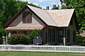
- Burlington Depot: An old train station on Seward Street, listed on March 5, 1981.
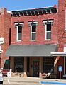
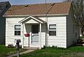
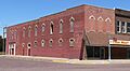
- City Pharmacy: Located at 410 N. Webster, this old pharmacy was listed on February 11, 1982.
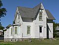
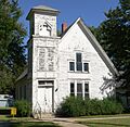
- William Ducker House: You can find this house at 821 Franklin Street. It was listed on February 11, 1982.
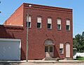
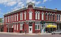
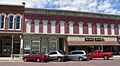
- Farmer's and Merchant's Bank Building: This historic bank at 338 N. Webster Street was listed on March 5, 1981.
- Dr. Gilbert McKeeby House: Located at 641 N. Cherry Street, listed on August 11, 1982.
- Miner Brothers Store: An old store at 3rd and Webster Streets, listed on August 11, 1982.
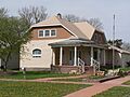
- Miner House: This house at 241 N. Seward was added on August 11, 1982.
- Moon Block: A building on Webster Street between 4th and 5th Avenues, listed on August 11, 1982.
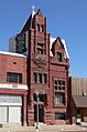
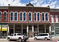
- Opera House: The old Opera House at 413 N. Webster was listed on August 11, 1982.
- Perkins-Wiener House: Located at 238 N. Seward, listed on August 11, 1982.
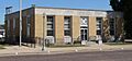
- US Post Office-Red Cloud: This post office at 300 N. Webster was listed on May 11, 1992. It's special because it has murals inside from 1941!
- Warner-Cather House: Found at 541 N. Seward Street, listed on August 11, 1982.
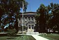
- Webster County Courthouse: The county's main government building at 225 W. 6th Street, listed on March 5, 1981.
Churches
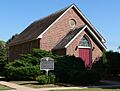
- First Baptist Church: This church at 442 N. Seward Street was listed on August 12, 1982.
- Grace Protestant Episcopal Church: Located at 546 N. Cedar Street, listed on February 11, 1982.
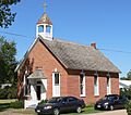
- St. Juliana Falconieri Catholic Church: This church at 425 W. 3rd Street was listed on March 5, 1981.
Historic Districts
These are areas with many historic buildings that together tell a story.
- Elm St. Historic District: This area is roughly bounded by 10th and 6th Avenues and Locust and Webster Streets. It was listed on August 11, 1982.
- Main Street Historic District: This district is roughly bounded by 3rd and 5th Avenues and Elm and Cedar Streets. It was listed on February 11, 1982.
- Railroad Addition Historic District: This area is roughly bounded by Vine, Division, Seward, Railroad, and 1st Streets. It was listed on August 11, 1982.
- Seward Street Historic District: This district is roughly bounded by Walnut and Cedar Streets and 10th and A Avenues. It was listed on February 11, 1982.
Other Historic Places in Webster County
Beyond Red Cloud, other important sites are scattered across Webster County.
Farms and Rural Sites
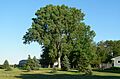
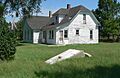
- George Cather Farmstead: Located southwest of Bladen, Nebraska, at 552 Road T. This farm was listed on August 11, 1982.
- William Cather Homestead Site: Northwest of Red Cloud, Nebraska, this homestead site was listed on August 11, 1982.
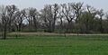
- Pavelka Farmstead: Southeast of Bladen, Nebraska, this farm was listed on April 13, 1979.
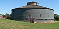
- Starke Round Barn: This unique round barn is 4.5 miles east of Red Cloud on U.S. Route 136. It was listed on March 16, 1972.
Natural and Cultural Sites
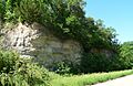
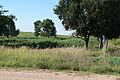
- Chalk Cliff and Republican River: About 1 mile south of Red Cloud, this natural area was listed on August 11, 1982.
- Crossroads Grave Site: Northwest of Red Cloud, this grave site was listed on August 11, 1982.
- Garber Grove: East of Red Cloud, this grove was listed on August 11, 1982.
- Jackson's Reserve: Bounded by Seward, Cedar, and 3rd Streets in Red Cloud, listed on August 11, 1982.
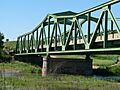
- Red Cloud Bridge: This bridge carries U.S. Route 281 over the Republican River, 2 miles south of Red Cloud. It was listed on June 29, 1992.
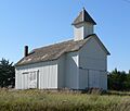
- St. Stephenie Scandinavian Evangelical Lutheran Church: About 8 miles northwest of Red Cloud, this church was listed on August 11, 1982.
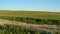
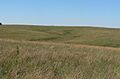
- Willa Cather Memorial Prairie: South of Red Cloud on U.S. Route 281, this prairie was listed on August 12, 1982. It helps preserve the landscape that inspired Willa Cather.
Other Buildings
- IOOF Hall and Opera House: Located on Main Street in Bladen, Nebraska, this building was listed on July 6, 1988.
Images for kids
-
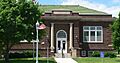
Auld Public Library
-
Matthew R. Bentley House
-
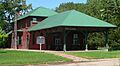
Burlington Depot
-
Willa Cather House
-
George Cather Farmstead
-
William Cather Homestead Site
-
Chalk Cliff and Republican River
-
City Pharmacy
-
Crossroads Grave Site
-
William Ducker House
-
Elm St. Historic District
-
Farmer's and Merchant's Bank Building
-
First Baptist Church
-
Garber Grove
-
Grace Protestant Episcopal Church
-
IOOF Hall and Opera House
-
Jackson's Reserve
-
Main Street Historic District
-
Dr. Gilbert McKeeby House
-
Miner Brothers Store
-
Miner House
-
Moon Block
-
Opera House
-
Pavelka Farmstead
-
Perkins-Wiener House
-
Pike-Pawnee Village Site
-
Railroad Addition Historic District
-
Red Cloud Bridge
-
St. Juliana Falconieri Catholic Church
-
St. Stephenie Scandinavian Evangelical Lutheran Church
-
Seward Street Historic District
-
Starke Round Barn
-
US Post Office-Red Cloud
-
Warner-Cather House
-
Webster County Courthouse
-
Willa Cather Memorial Prairie

_from_SE_2.JPG)


_2.jpg)


_from_N_2.JPG)


_from_NW_1.JPG)

_from_NE.jpg)

_from_SE.JPG)


_from_SE.jpg)


