
National Register of Historic Places listings in Winneshiek County, Iowa facts for kids

Winneshiek County in Iowa is home to many cool and important places! These spots are listed on something called the National Register of Historic Places. Think of it like a special list of buildings, areas, or objects that are super important to American history, architecture, archaeology, engineering, or culture. When a place is on this list, it means it's worth protecting and remembering for future generations.
In Winneshiek County, there are 33 places on this special list. Some of them are old houses, some are schools, and others are even natural wonders! Let's explore some of these amazing historic sites.
Contents
Exploring Historic Places in Winneshiek County
Winneshiek County has a rich history, and many of its important places are recognized nationally. These sites tell stories about how people lived, worked, and built communities long ago.
Old Buildings and Homes
Many of the historic places are old buildings that show us how people lived in the past.
Burr Oak House/Masters Hotel

The Burr Oak House, also known as the Masters Hotel, is in the town of Burr Oak. This building is famous because it was once a hotel where the famous author Laura Ingalls Wilder and her family lived for a short time. Today, it's a museum where you can learn about her life and the history of the area.
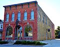
Burr Oak Savings Bank

Also in Burr Oak is the old Burr Oak Savings Bank. This building, built in 1910, is now used as a visitor center for the museum. It's a great example of early 20th-century architecture.
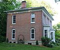
Cooley-Whitney House

The Cooley-Whitney House is a beautiful old home located in Decorah. It was built in 1872 and is a great example of the fancy homes built during that time.
Ellsworth-Porter House

Another historic house in Decorah is the Ellsworth-Porter House. Built in 1867, it's now known as the Porter House Museum. It's a wonderful place to see how people lived in the 1800s and learn about the families who called it home.
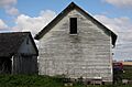
Horn House

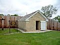
The Horn House is located northwest of Decorah. This old farmhouse gives us a peek into the rural life of Winneshiek County's past.
Jacobson Farm

Southeast of Decorah, you'll find the Jacobson Farm. This farm was listed in 1982, showing the importance of agriculture in the region's history.
Norris Miller House

The Norris Miller House in Decorah is part of the Vesterheim Norwegian-American Museum. This museum celebrates the history and culture of Norwegian immigrants in America. The house itself is a great example of early Norwegian-American architecture.
Wenzil Taylor Building

In Spillville, the Wenzil Taylor Building is a historic commercial building. It shows what main street businesses looked like many years ago.
Schools and Learning Centers
Some of the historic places are old schools, which are important for understanding education in the past.
Frankville School

The Frankville School, located in Frankville, is a historic school building. It reminds us of a time when schools were often small, one-room buildings in rural areas.
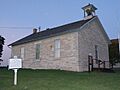
Highlandville School

The Highlandville School is another historic school building in the Decorah area. It's a great example of the kind of schoolhouses that served communities in the early 20th century.
Locust School

North of Decorah, the Locust School is another example of a historic rural school. These buildings are important reminders of how education has changed over time.
Koren Hall (Luther College)

Koren Hall is located on the campus of Luther College in Decorah. It was built in 1907 and is an important part of the college's history. It was originally the college library.
Luther College Campus Historic District

The entire campus of Luther College is recognized as a historic district. This means that many of its buildings and the overall layout of the campus are considered historically important.
Luther College Farm

Even the Luther College Farm is on the National Register! This shows the long history of farming and agricultural education connected to the college.
Cool Natural and Industrial Sites
Winneshiek County also has some unique natural and industrial sites on the list.
Birdsall Lime Kiln
The Birdsall Lime Kiln, northeast of Decorah, is an old structure used to produce lime. Lime was an important material for building and farming in the past. This kiln is a reminder of early industries in the area.
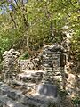
Decorah Ice Cave

The Decorah Ice Cave is a natural wonder! It's a cave that stays icy cold, even in summer, because of how air circulates through it. It's a fascinating natural landmark.
Decorah Woolen Mill

The Decorah Woolen Mill was a place where wool was processed into fabric. This mill, built in 1867, is a great example of the early manufacturing industries in the region.
Painter-Bernatz Mill

The Painter-Bernatz Mill is another historic mill in Decorah, also part of the Vesterheim Norwegian-American Museum. It was built in 1871 and was used to grind grain.
Historic Districts and Other Sites
Some listings are entire areas, called historic districts, or other unique structures.
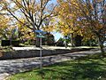
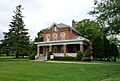
Broadway-Phelps Park Historic District

This district in Decorah includes many historic homes and buildings around Broadway and Phelps Park. It shows how neighborhoods developed over time.
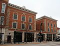
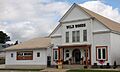
Decorah Commercial Historic District

The downtown area of Decorah, specifically around Water Street, is a historic district. This area has many old shops and buildings that show what the town's main business area looked like in the past.
Decorah Municipal Bathhouse and Swimming Pool

The Decorah Municipal Bathhouse and Swimming Pool, built in the 1930s, is a historic example of public recreation facilities from that era.
Fort Atkinson Historic District

Fort Atkinson was a U.S. Army fort built in the 1840s. It was used to oversee the Ho-Chunk people who were moved to the area. Today, it's a state preserve where you can learn about its history.
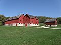
Kinney Octagon Barn

The Kinney Octagon Barn, near Burr Oak, is a very unique barn because of its eight-sided shape! Octagon barns were popular for a short time because people thought they were more efficient.
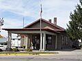
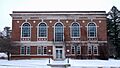
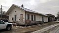
Milwaukee and St. Paul Railway Combination Depot

This old train station in Decorah was built in 1888. It's a reminder of when trains were the main way people and goods traveled across the country.
Ossian Opera House

The Ossian Opera House in Ossian was a center for entertainment and community gatherings. Opera houses were important social hubs in towns long ago.
Steyer Opera House

Another opera house, the Steyer Opera House in Decorah, also served as a place for performances and events. It was built in 1870.
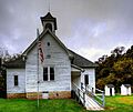
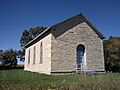
Washington Prairie Methodist Church

Southeast of Decorah, the Washington Prairie Methodist Church is a historic church building. It shows the importance of faith and community in the early settlement of the area.
Historic Bridges
Several old bridges in Winneshiek County are also on the National Register. These bridges are important examples of early engineering.
Fort Atkinson Bridge

This bridge crosses the Turkey River near Fort Atkinson. It's an example of an old bridge design.
Steyer Bridge

The Steyer Bridge is another historic bridge near Decorah. It's a good example of the craftsmanship used in building bridges in the past.
Former Historic Listings
Some places were once on the National Register but have since been removed. This can happen if a building is demolished, moved, or changed so much that it no longer has its historic importance.
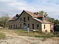
- Big Stone Mills: This mill in Spillville was removed from the list because it was torn down in 2011.
- Freeport Bowstring Arch Bridge: This bridge was delisted after it was moved to a new location.
- Turkey River Bridge: This bridge near Festina was demolished and replaced in 2010.
Images for kids
-
A historic home in the Broadway-Phelps Park Historic District.
-

The historic Masters Hotel in Burr Oak.
-

The old Burr Oak Savings Bank building.
-
The Calmar Passenger Depot.
-

The Cooley-Whitney House in Decorah.
-
The Winneshiek Hotel in the Decorah Commercial Historic District.
-
The entrance to the Decorah Ice Cave.
-

The Decorah Municipal Bathhouse.
-

The historic Decorah Woolen Mill.
-

The Ellsworth-Porter House, now a museum.
-

The Fort Atkinson Bridge.
-
A building at Fort Atkinson State Preserve.
-
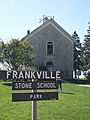
The old Frankville School building.
-
The Highlandville School.
-
The historic Horn House.
-
The Jacobson Farm.
-

The unique Kinney Octagon Barn.
-
Koren Hall on the Luther College campus.
-
The Locust School building.
-
A building on the Luther College campus.
-
The Luther College Farm.
-

The Norris Miller House, part of the Vesterheim Museum.
-
The Milwaukee and St. Paul Railway Combination Depot.
-
The Ossian Opera House.
-

The Painter-Bernatz Mill, part of the Vesterheim Museum.
-

The Steyer Bridge.
-

Inside the Steyer Opera House in Decorah.
-
The Wenzil Taylor Building in Spillville.
-
The Washington Prairie Methodist Church.
-
The Big Stone Mills in Spillville (now demolished).
-
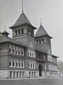
Decorah East Side Elementary and Middle School (now delisted).
-

The Freeport Bowstring Arch Bridge (now delisted).


