
National Register of Historic Places listings in Yuma County, Arizona facts for kids

Have you ever wondered about the old buildings and special places in your town? In Yuma County, Arizona, there are many important spots that tell stories about the past. These places are so special that they are listed on the National Register of Historic Places. This is like a special list kept by the United States government to protect and celebrate buildings, sites, and objects that are important to history.
When a place is on this list, it means it has a unique story to tell about American history, architecture, archaeology, engineering, or culture. It helps make sure these places are kept safe for future generations, like you, to learn from and enjoy. Yuma County has 57 places on this list, and one of them is even more special, called a National Historic Landmark! Let's explore some of these amazing historic sites.
Contents
What is the National Register of Historic Places?
The National Register of Historic Places is the official list of the nation's historic places worth saving. It's part of a program to help coordinate and support public and private efforts to identify, evaluate, and protect historic and archaeological resources. Being on the Register means a place is recognized for its importance to local, state, or national history. It doesn't stop people from owning or changing their property, but it encourages them to preserve its historic character.
Historic Buildings in Yuma City
Many of Yuma County's historic places are found right in the city of Yuma. These include old homes, schools, and even a theater!
Old Homes with Stories
Many houses in Yuma are on the historic list. They show us how people lived long ago and what kinds of buildings were popular.
- The Balsz House at 475 2nd Avenue was listed in 1982.
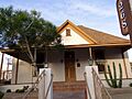
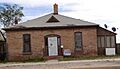
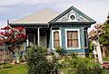
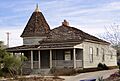
- The Brown House at 268 S. 1st Avenue is another example, also listed in 1982.
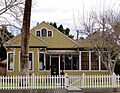
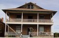
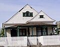
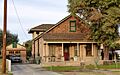
- The Brownstetter House at 627 Orange Avenue, listed in 1982, shows us a different style of home.
- The Frank Ewing House and Ruth Ewing House at 700 and 712 2nd Avenue, respectively, were both listed in 1982. These homes give us a peek into family life from the past.
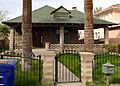
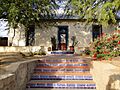
- The Alfred Griffin House at 641 1st Avenue and the Henry Levy House at 602 2nd Avenue are more examples of historic homes.
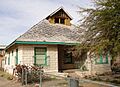
- The J. Homer Smith House at 600 5th Avenue was listed in 1982.
Important Public Buildings
Yuma also has historic public buildings that were central to community life.
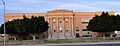
- The Fourth Avenue Junior High School at 450 S. 4th Avenue was listed in 1982. Imagine going to school in a building that's now a historic landmark!
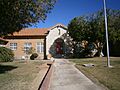
- The Roosevelt School at 550 W. 5th Street is another historic school, listed in 1982.
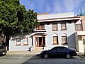
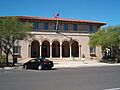
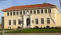
- The Yuma City Hall at 181 W. 1st Street, listed in 1982, was once the center of local government.
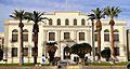
- The Yuma County Courthouse at 168 S. 2nd Avenue, listed in 1982, is where important legal decisions were made for the county.
Historic Districts and Downtown Areas
Sometimes, a whole group of buildings in an area is historic. These are called historic districts.
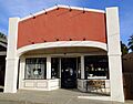
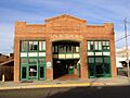
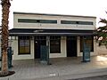
- The Brinley Avenue Historic District in Yuma, listed in 1982, includes several streets and buildings like the Venegas Store. It shows how a neighborhood looked and functioned in the past.
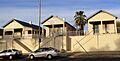
- The Yuma Century Heights Conservancy Residential Historic District, listed in 1988, is another area with many old homes.
- The Yuma Main Street Historic District, listed in 1994, includes buildings on Main Street and West 3rd Street. This area was the heart of Yuma's business and social life.
Historic Transportation and Engineering
Yuma County has several historic sites related to how people traveled and how engineers built important structures.
Bridges that Connect History
Bridges are often important because they help people cross rivers or difficult terrain.
- The Antelope Hill Highway Bridge, northwest of Tacna, was listed in 1979. It spans the Gila River.
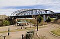
- The McPhaul Suspension Bridge, west of Dome, was listed in 1981. Suspension bridges are cool because their decks hang from cables.
- The Ocean To Ocean Bridge on Penitentiary Avenue in Yuma, listed in 1979, was a vital crossing point.
Railroad History
Railroads played a huge role in connecting different parts of the country.
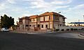
- The Southern Pacific Freight Depot on Main Street in Yuma, listed in 1987, was where goods were loaded and unloaded from trains.
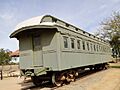
- The Southern Pacific Railroad Passenger Coach Car-S.P. X7 at 201 N. 4th Avenue in Yuma, listed in 2000, is an actual train car! It helps us imagine what train travel was like.
Other Unique Historic Sites
Yuma County has other interesting places that are important for different reasons.
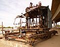
- The Blaisdell Slow Sand Filter Washing Machine on N. Jones Street in Yuma, listed in 1979, is an example of old technology used for water purification. It shows how people solved problems in the past.
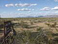
- El Camino Del Diablo (The Devil's Highway), northwest of Lukeville, was listed in 1978. This was a very difficult and dangerous trail used by travelers long ago.
- The Camp Horn Monument near Dateland, listed in 2003, marks a historic military site.
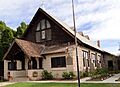
- The Mohawk Valley School at 5151 South Ave. 39 East in Roll, listed in 1986, is another example of a historic school building.
National Historic Landmark: Yuma Crossing
One of the most important sites in Yuma County is the Yuma Crossing and Associated Sites, located on the banks of the Colorado River in Yuma. This site was listed as a National Historic Landmark in 1966. A National Historic Landmark is a place that has been recognized by the U.S. government as having exceptional historical importance to the nation.
The Yuma Crossing was a crucial point where people could easily cross the Colorado River. For thousands of years, Native Americans used this crossing. Later, Spanish explorers, American pioneers, and settlers also used it. It was a vital spot for trade, travel, and military movements, making it incredibly important to the history of the American Southwest.
Images for kids
-
The Blaisdell Slow Sand Filter Washing Machine in Yuma.
-
The Venegas Store, part of the Brinley Avenue Historic District.
-
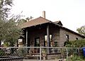
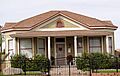
The historic Brown House in Yuma.
-
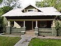
The Brownstetter House.
-
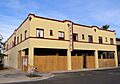
The Dressing Apartments.
-
A section of El Camino del Diablo.
-
The Frank Ewing House.
-
The Ruth Ewing House.
-
The Fourth Avenue Junior High School.
-
The Fredley Apartments.
-
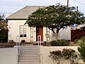
The Gandolfo Theater.
-
The Alfred Griffin House.
-
The Hotel del Ming.
-
The E.B. Jackson House.
-
The Lee Hotel.
-
The Henry Levy House.
-
The George Marable House.
-
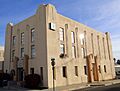
The Masonic Temple.
-
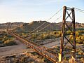
The McPhaul Suspension Bridge.
-
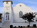
The former Methodist Episcopal Church.
-
The Methodist Parsonage.
-
The A.B. Ming House.
-
The Norton House.
-
The Ocean To Ocean Bridge.
-
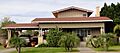
The Ortiz House.
-
The Pancrazi House.
-
The Pauley Apartments.
-
The Power Apartments.
-
The Clara Smith Riley House.
-
The Roosevelt School.
-
The Russell-Williamson House.
-
Old St. Paul's Episcopal Church.
-
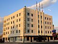
The San Carlos Hotel.
-
The J. Homer Smith House.
-
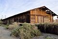
The Southern Pacific Freight Depot.
-
The Southern Pacific Railroad Depot (now razed).
-
The Southern Pacific Railroad Passenger Coach Car-S.P. X7.
-
The Stoffela Store/Railroad Exchange.
-
The US Post Office-Yuma Main.
-
The Yuma Century Heights Conservancy Residential Historic District.
-
The Old Yuma City Hall.
-
The Yuma County Courthouse.
-
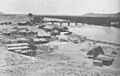
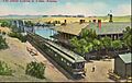
The Yuma Crossing and Railroad bridge in 1886.
-
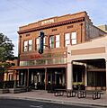
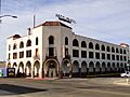
The Kress Building, part of the Yuma Main Street Historic District.


