
Necropolis of Pantalica facts for kids
| UNESCO World Heritage Site | |
|---|---|
 |
|
| Location | Sortino, Province of Syracuse, Sicily, Italy |
| Part of | Syracuse and the Rocky Necropolis of Pantalica |
| Inscription | 2006 (30th Session) |
| Area | 205.86 ha (508.7 acres) |
| Buffer zone | 3,699.7 ha (9,142 acres) |
The Necropolis of Pantalica is a huge collection of ancient burial sites in southeast Sicily, Italy. It has thousands of tombs carved into rocks, dating back from about 1250 BC to 650 BC. Experts once thought there were over 5,000 tombs, but now they believe there are closer to 4,000.
These tombs spread out around a big rocky hill where the Anapo and Calcinara rivers meet. This spot is about 23 kilometers (14 miles) northwest of Syracuse. In 2005, Pantalica became a UNESCO World Heritage Site, along with the nearby city of Syracuse.
Contents
Exploring the Geography of Pantalica
Pantalica sits on a high limestone hill. Deep river gorges surround it, formed by the Anapo and Calcinara rivers. You can find it between the towns of Ferla and Sortino in southeastern Sicily.
A Nature Reserve with Caves
Besides its amazing old tombs, Pantalica is also an important nature reserve. It's called the Riserva Naturale Orientata Pantalica. This area is home to many local plants and animals. It also has natural caves, like the famous Grotta dei Pipistrelli, which means "Bat Cave."
Getting Around Pantalica
There are several paths for visitors to explore. One cool path is an old railway track. This track was taken apart in 1956. It runs along the bottom of the Anapo valley. You can drive to the promontory directly from Ferla. Or, you can walk down an old mule track from the parking area on the road from Sortino. This path crosses the Calcinara stream.
The Ancient History of Pantalica
Around 1250 BC, people started leaving their homes near the coast in Sicily. This might have happened because a group called the Sicels arrived on the island. Conditions became less peaceful. New, large settlements like Pantalica appeared inland, in hilly areas. These spots were probably chosen because they were easier to defend.
Pantalica's Golden Age
Pantalica was a busy and important place for about 600 years. This was from roughly 1250 BC to 650 BC. The name "Pantalica" likely comes from the Middle Ages or the Arab period. We don't know the ancient name for sure. Some archaeologists think it might have been Hybla. This name comes from a Sicel king named Hyblon. He is mentioned by the historian Thucydides. Hyblon is linked to the founding of the early Greek colony at Megara Hyblaea in 728 BC.
For several centuries before the Greeks arrived, Pantalica was a main center in eastern Sicily. It controlled the land around it, including smaller towns.
Decline and Later Use
By about 650 BC, Pantalica started to lose its power. The city of Syracuse was growing. Syracuse set up a new outpost at Akrai (near Palazzolo Acreide) around this time. Even so, people still lived in Pantalica during later periods. We know this from items found from the 4th and 3rd centuries BC (the Hellenistic period). It was also used during the late Roman and Byzantine times. After the 12th century, Pantalica was mostly empty. The nearby town of Sortino became more important.
What Remains Today
Today, you can mostly see many ancient burial chambers. These are cut into the limestone rock. Some tombs have a small porch or a short hallway leading to the burial room. They were originally sealed with stones or a slab. There are also some larger rock-cut houses. We're not sure when these were built. People often say they are Byzantine, but they might be older.
The anaktoron, or "princely palace," is near the top of the hill. It's a bit of a mystery. Some archaeologists believe it was a Late Bronze Age building. They think it was inspired by grand palaces from the Greek (Mycenaean) Bronze Age. However, it was definitely used during the Byzantine period.
You can clearly see the remains of a large ditch at Filiporto. This ditch is cut into the limestone. It's on the western side of the hill, closest to Ferla. This ditch probably dates to the 4th century BC. It was a defensive structure built by the Greeks. It might have been part of a plan by Dionysius of Syracuse to protect allied sites inland.
There are also three small medieval chapels carved into the rock. They are called the Grotta del Crocifisso, the Grotta di San Nicolicchio, and the Grotta di San Micidario. These chapels have very faint traces of old paintings. They show that small groups of monks once lived here.
Archaeological Discoveries
The site was mainly dug up between 1895 and 1910. This work was done by the Italian archaeologist, Paolo Orsi. However, most of the tombs had already been robbed long before he arrived. The items Orsi found are now on display. You can see them in the Archaeological Museum in Syracuse.
These finds include special red pottery. There are also metal objects, like small knives and daggers. Other items include bronze fibulae (brooches) (brooches) and rings. These were placed with the dead inside the tombs. Most tombs held between one and seven people. These included people of all ages and both sexes. Many tombs were clearly opened again and again for more burials. During this time, the average person probably lived to about 30 years old. It's hard to guess the size of the ancient population. But it might have been 1000 people or more.
Main Areas to Explore at Pantalica
Pantalica has five main burial areas, called necropoleis. They are spread out over a large area.
- The Filiporto Necropolis has almost 1000 tombs. It's on the southwestern side of the hill. You can reach it by road from Ferla. In this same area, you can see the remains of a defensive ditch. This ditch was cut into the rock later, probably in the 4th century BC. It crosses the narrowest part of the hill.
- The North West Necropolis is one of the oldest burial sites. It dates back to the 12th and 11th centuries BC. The paved road from Ferla goes right through it.
- The Cavetta Necropolis has tombs and houses carved into the rock. These are from ancient times and later periods. You can see them from the road and from special viewing spots.
- The North Necropolis is a stunning cemetery with about 1000 tombs. They cover very steep slopes overlooking the Calcinara river. This area is best seen from the path coming from Sortino. You can also see it from viewing platforms near the path. Remains of large rock-cut homes are on the gentler slopes to the east.
- The South Necropolis stretches along the Anapo river for over 1 kilometer. It's easy to see from the track at the bottom of the valley. A path leads down to it from the anaktoron. The old railway station here has been restored. It offers information about the local animals and plants.
The Anaktoron: A Princely Palace?
The building known as the Anaktoron is on top of the hill. It means "princely palace." It's a large building made of big stone blocks, with several rectangular rooms. Paolo Orsi dug it up in the 19th century. We don't know much about its original purpose (see above). But it was definitely used during the Byzantine period. We know this from roof tiles and pottery found there. No other ancient houses have been found on the hilltop. The top of the hill is quite worn away. So, we're not sure where the original homes of the ancient people were. There might have been different groups of homes near each main burial area.
Images for kids
-
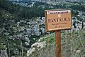
The site marker for the necropoli
-
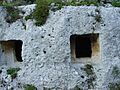
Square rock-cut tombs in Pantalica
-
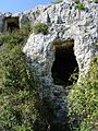
Tomb entrance in Pantalica
-
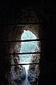
The view looking out of a necropolis


