Nedlands, Western Australia facts for kids
Quick facts for kids NedlandsPerth, Western Australia |
|||||||||||||||
|---|---|---|---|---|---|---|---|---|---|---|---|---|---|---|---|

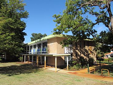
Nedlands library
|
|||||||||||||||
| Postcode(s) | 6009 | ||||||||||||||
| Area | 5.3 km2 (2.0 sq mi) | ||||||||||||||
| Location | 7 km (4 mi) WSW of the Perth CBD | ||||||||||||||
| LGA(s) |
|
||||||||||||||
| State electorate(s) | Nedlands | ||||||||||||||
| Federal Division(s) | Curtin | ||||||||||||||
|
|||||||||||||||
Nedlands is a suburb located west of Perth, the main city in Western Australia. It's part of two local government areas: the City of Nedlands and the City of Perth. Nedlands is about 7 kilometers (4.3 miles) from the center of Perth. You can get there by using roads like Thomas Street or Mounts Bay Road.
Contents
What Nedlands is Like
Nedlands is a suburb with many different kinds of places. It has a mix of homes and important buildings.
Homes and Shops
- You can find homes for students who go to the nearby University of Western Australia.
- There are also large, fancy homes and a golf course called Nedlands Golf Club.
- Along Stirling Highway, there's a busy area with shops, restaurants, and a small movie theater called Windsor Cinema.
Hospitals and Research
Nedlands is home to several important medical places:
- The Lions Eye Institute does research to help people with eye diseases.
- Sir Charles Gairdner Hospital is one of Perth's biggest public hospitals.
- Hollywood Private Hospital used to be a hospital for soldiers. It is next to places for older people to live.
- The Perth Children's Hospital is also here. It is part of the Queen Elizabeth II Medical Centre complex.
These hospitals and Stirling Highway are easy to reach by bus. Nedlands also has grocery stores and a library for everyone to use.
Parks and Gardens
Nedlands has a special place called the Peace Memorial Rose Garden. It is on Stirling Highway. This garden remembers people who lost their lives in wars. The Rose Society and the Nedlands Road Board created it in the 1950s. It was officially opened in 1951.
Getting Around Nedlands
Buses are a great way to travel in Nedlands. Many bus routes serve the area. These include the CircleRoute and other services along Stirling Highway, Hampden Road, Broadway, and Princess Road. All these bus services are run by Swan Transit.
Bus Routes in Nedlands
Here are some of the bus routes that go through Nedlands:
- Route 23: Travels from Claremont Station to Elizabeth Quay Bus Station. It uses Bruce Street, Cooper Street, and Stirling Highway.
- Route 24: Goes from Claremont Station to Point Fraser. It covers Bruce Street, Hillway, Broadway, Hampden Road, Monash Avenue, and Hospital Avenue.
- Route 25: Connects Claremont Station to Shenton Park Station. This route uses Princess Road, Dalkeith Road, Carrington Street, Smyth Road, Monash Avenue, Hospital Avenue, and Aberdare Road.
- Route 103: Runs from Claremont Station to Elizabeth Quay Bus Station. It follows Stirling Highway, Hampden Road, Monash Avenue, and Hospital Avenue.
- Route 950: This is a frequent bus service from Queen Elizabeth II Medical Centre to Morley Bus Station. It travels along Hospital Avenue, Monash Avenue, and Hampden Road.
- Route 995: Another frequent service, going from Claremont Station to Elizabeth Quay Bus Station via Stirling Highway.
- Route 998: This is part of the CircleRoute (clockwise). It has limited stops and serves Stirling Highway, Hospital Avenue, and Aberdare Road.
- Route 999: This is the anti-clockwise part of the CircleRoute. It also has limited stops and uses Aberdare Road, Hospital Avenue, and Stirling Highway.
Other bus routes that serve Broadway, Hampden Road, Monash Avenue, and Hospital Avenue include:
- Purple CAT: A free bus service from the University of Western Australia to Elizabeth Quay Bus Station.
- Route 96: Goes from the University of Western Australia South to Leederville Station.
- Route 97: Travels from the University of Western Australia South to Subiaco Station.
Nedlands Weather
Nedlands is a bit cooler and gets more rain than the main part of Perth. This is because it is located on higher ground.
| Climate data for Nedlands | |||||||||||||
|---|---|---|---|---|---|---|---|---|---|---|---|---|---|
| Month | Jan | Feb | Mar | Apr | May | Jun | Jul | Aug | Sep | Oct | Nov | Dec | Year |
| Mean daily maximum °C (°F) | 29.6 (85.3) |
29.7 (85.5) |
27.6 (81.7) |
23.8 (74.8) |
20.7 (69.3) |
18.5 (65.3) |
17.5 (63.5) |
18.1 (64.6) |
19.4 (66.9) |
21.6 (70.9) |
24.4 (75.9) |
27.0 (80.6) |
23.2 (73.8) |
| Mean daily minimum °C (°F) | 17.8 (64.0) |
18.1 (64.6) |
16.6 (61.9) |
13.3 (55.9) |
10.9 (51.6) |
9.7 (49.5) |
8.5 (47.3) |
8.4 (47.1) |
9.6 (49.3) |
11.4 (52.5) |
13.7 (56.7) |
16.0 (60.8) |
12.8 (55.0) |
| Average precipitation mm (inches) | 7.7 (0.30) |
12.1 (0.48) |
17.4 (0.69) |
50.3 (1.98) |
110.8 (4.36) |
186.8 (7.35) |
170.3 (6.70) |
114.3 (4.50) |
69.9 (2.75) |
49.8 (1.96) |
19.4 (0.76) |
12.7 (0.50) |
836.5 (32.93) |
| Average precipitation days | 2.2 | 2.0 | 3.4 | 7.6 | 12.1 | 17.3 | 17.9 | 17.9 | 12.2 | 9.1 | 4.8 | 4.8 | 106.6 |
Famous People from Nedlands
- David Indermaur is a clinical psychologist who is from Nedlands.
 | Leon Lynch |
 | Milton P. Webster |
 | Ferdinand Smith |

