Neibert, West Virginia facts for kids
Quick facts for kids
Neibert, West Virginia
|
|
|---|---|

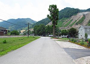
Neibert Bottom Road
|
|
| Country | United States |
| State | West Virginia |
| County | Logan |
| Area | |
| • Total | 0.630 sq mi (1.63 km2) |
| • Land | 0.612 sq mi (1.59 km2) |
| • Water | 0.018 sq mi (0.05 km2) |
| Elevation | 718 ft (219 m) |
| Population
(2010)
|
|
| • Total | 183 |
| • Density | 299.0/sq mi (115.4/km2) |
| Time zone | UTC-5 (Eastern (EST)) |
| • Summer (DST) | UTC-4 (EDT) |
| ZIP Code |
25632 (Lyburn)
|
| Area code(s) | 304 & 681 |
| GNIS feature ID | 1544085 |
| FIPS code | 54-57916 |
Neibert is a small place in Logan County, West Virginia, in the United States. It is known as an unincorporated community. This means it's a place with people living there, but it doesn't have its own local government like a city or town.
It's also called a census-designated place (CDP). This is a special area the government defines just for counting people during a census. In 2010, 183 people lived in Neibert.
Where is Neibert Located?
Neibert is in the southern part of Logan County, West Virginia. It sits on the east side of the Guyandotte River. This river is an important natural feature in the area.
The main road through Neibert is Hanging Rock Highway. This road used to be part of West Virginia Route 10. If you travel northwest (down the river) about 8 miles (13 km), you'll reach Logan. Logan is the main town and the county seat for Logan County.
If you go southeast (up the river) about 6 miles (10 km), you'll find the town of Man. The current West Virginia Route 10 is a bigger, four-lane highway. It goes around Neibert on the west side of the river. The closest way to get onto this highway is about 0.8 miles (1.3 km) south of Neibert. This is where Hanging Rock Highway crosses the new WV-10.
Land and Water
The area of Neibert, as measured for the census, is about 0.6 square miles (1.6 square kilometers). Most of this area is land. Only a small part, about 0.02 square miles (0.05 square kilometers), is water. This water area makes up about 2.83% of Neibert's total size.
See also
 In Spanish: Neibert (Virginia Occidental) para niños
 | DeHart Hubbard |
 | Wilma Rudolph |
 | Jesse Owens |
 | Jackie Joyner-Kersee |
 | Major Taylor |


