Nepal–Britain Treaty of 1860 facts for kids

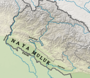
Lands returned by the treaty
|
|
| Context | To return the Naya Muluk |
|---|---|
| Signed | 1 November 1860 |
| Signatories | |
| Languages | Nepali, English |
The Nepal–Britain Treaty was an important agreement signed on 1 November 1860. It took place in Kathmandu, the capital of Nepal. The treaty was signed by Jung Bahadur Rana for Nepal's King Surendra Bikram Shah. George Ramsay signed for the British, representing Charles Canning, 1st Earl Canning, who was the Governor-General of India. The treaty was officially approved on 15 November 1860 in Calcutta.
This treaty gave back certain lands to Nepal. These lands were part of the Terai region. They had been given to the British earlier by the Treaty of Sugauli. The returned areas included the districts of Kanchanpur, Kailali, Bardiya, and Banke. These lands are often called the Naya Muluk, which means "New Country" in Nepali.
Contents
Why the Treaty Was Signed
This treaty was a way for the British to thank Nepal. Nepal had helped the British during a big uprising in India in 1857. This event is often called the Indian Mutiny. Nepal's leader, Jung Bahadur Rana, sent troops to help the British. They helped keep order in border areas. Later, Nepali soldiers also helped the British army. They worked together to recapture the city of Lucknow. They also helped defeat the rebels.
Because of this help, the British decided to return the lands. These lands had belonged to Nepal before 1815. They were given to the British in that year by the Treaty of Sugauli.
What the Treaty Said
The 1860 Nepal–Britain Treaty had a few main points:
Confirming Old Agreements
- All previous treaties and agreements between Britain and Nepal were still valid.
- The new treaty only changed parts that were specifically mentioned in it.
Returning the Lands
- The British Government officially gave back the lowlands to Nepal.
- These lands were located between the Kali River and the Raptee River.
- They also included the lowlands between the Raptee River and the Gorakhpur District.
- These were the same lands that Nepal owned in 1815.
- They had been given to the British in 1815 by the Treaty of Sugauli.
Marking the New Border
- British officials had surveyed the new border line.
- This line stretched from the Kali River (also called Sardah) eastward.
- It went to the foot of the hills north of Bagowra Tal.
- Stone pillars were put in place to mark this new border.
- This line became the official boundary between the British Province of Oudh and Nepal.
- The land was formally handed over to Nepali officials.
See also
 | Kyle Baker |
 | Joseph Yoakum |
 | Laura Wheeler Waring |
 | Henry Ossawa Tanner |

