
Ness of Burgi facts for kids
 Northern part of the Ness looking inland towards Scatness. The structure in the foreground is part of the Ness of Burgi fort |
|
| OS grid reference | HU 3877 0855 |
|---|---|
| Coordinates | 59°51′35″N 1°18′38″W / 59.859644°N 1.31042°W |
| Physical geography | |
| Island group | Shetland |
| Administration | |
| Sovereign state | United Kingdom |
| Country | Scotland |
| Council area | Shetland Islands |
The Ness of Burgi is a narrow piece of land that sticks out into the sea. It's located on Mainland, Shetland, a Scottish island. This special place is part of the Dunrossness area. It stretches south from the Scat Ness headland.
This thin strip of land is less than 1 kilometer (about 0.6 miles) long. It points towards the south-southwest from Scat Ness. At its very end, you'll find rocks known as the Hog of the Ness. Out in the water near this point are two small islands: the Hog of the Holm and Horse Island.
The Ancient Ness of Burgi Fort
The most exciting feature of the Ness of Burgi is an old fort. This fort was likely built around 100 BC during the Iron Age. The Iron Age was a time when people learned to make tools and weapons from iron.
What the Fort Looks Like
The Ness of Burgi fort is separated from the rest of the land. It has a large earth wall, called a rampart, and ditches on both sides. These features helped protect the fort from invaders. There's also a ruined stone wall, now covered in grass, that runs across the land. This wall might have been part of the fort's defenses too.
Exploring the Fort
In 1935, a person named Miss C L Mowbray studied the fort. She dug up parts of the site to learn more about its history.
The fort is about 1.6 kilometers (1 mile) south of the village of Scatness. You can reach it by walking along a grassy path. This path leads directly to the Ness of Burgi. The fort itself is on a rocky point on the east side of the Ness. It's open to everyone all the time, so you can visit and imagine life in the Iron Age!
Gallery
-
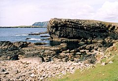
Hog of Breigeo, Ness of Burgi. This geo is typical of the rocky promontory of Ness of Burgi.
-
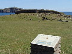
Ness of Burgi fort Iron Age blockhouse at the Ness of Burgi. Sumburgh Head lighthouse in the distance
-
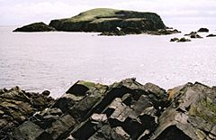
Horse Island from Hog of the Ness


