Netherdale, Queensland facts for kids
Quick facts for kids NetherdaleQueensland |
|||||||||||||||
|---|---|---|---|---|---|---|---|---|---|---|---|---|---|---|---|
| Population | 121 (2021 census) | ||||||||||||||
| • Density | 2.547/km2 (6.60/sq mi) | ||||||||||||||
| Postcode(s) | 4756 | ||||||||||||||
| Area | 47.5 km2 (18.3 sq mi) | ||||||||||||||
| Time zone | AEST (UTC+10:00) | ||||||||||||||
| LGA(s) | Mackay Region | ||||||||||||||
| State electorate(s) | Mirani | ||||||||||||||
| Federal Division(s) | Capricornia | ||||||||||||||
|
|||||||||||||||
Netherdale is a small, quiet place in the countryside of Queensland, Australia. It's located in the beautiful Mackay Region. In 2021, about 121 people called Netherdale home. It's known for its lovely natural scenery and being at the western end of the Pioneer Valley.
Contents
Geography
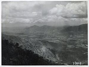
Netherdale is the most western area of the Pioneer River Valley. While the Pioneer River doesn't flow directly through Netherdale, the area is part of its larger water system. The main road, called the Mackay–Eungella Road, goes through Netherdale from east to west. After Netherdale, this road climbs up the Clarke Range towards a place called Eungella.
The northern and southern parts of Netherdale are mountainous. These mountains are part of the Clarke Range and reach heights of up to 890 metres (about 2,920 feet) in the north and 670 metres (about 2,198 feet) in the south. In between these mountains is a valley where the road runs. This valley is about 140 metres (459 feet) high in the east and rises to 180 metres (590 feet) in the west. The land in the valley is used for growing sugar cane and for grazing animals, which is common in the Pioneer Valley. The mountainous areas in the north and south of Netherdale are mostly untouched by development.
History
The Mackay Railway line was extended to Netherdale in 1911. Before that, the railway ended in Finch Hatton. Netherdale had two railway stations:
- Okuloo railway station (21°08′19″S 148°33′49″E / 21.1385°S 148.5637°E)
- Netherdale railway station (21°08′28″S 148°32′06″E / 21.1412°S 148.5351°E), which was also known as Eungella Range railway station.
Both the railway line and these stations stopped operating in 1977.
A school called Netherdale State School opened on January 24, 1914. It was originally planned to be named Eungella Range State School. This school closed its doors on December 31, 1963.
On April 21, 1928, a special ceremony took place for the Netherton Methodist Church. The church was officially opened to the public on Saturday, June 6, 1928.
Netherdale used to be part of the Shire of Mirani. However, in 2008, the Shire of Mirani joined with other areas to form the larger Mackay Region.
Population
In 2016, Netherdale had a population of 111 people. By 2021, the number of people living in Netherdale had grown slightly to 121.
Things to See
One of the main attractions near Netherdale is Peases Lookout. This lookout offers amazing wide views of the entire Pioneer River Valley. Even though it's technically within Netherdale's boundaries, you can only get to it from Dalrymple Road in the nearby town of Eungella (21°07′00″S 148°31′00″E / 21.1166°S 148.5166°E). The lookout was named after Percy Pease, who was a local politician in the Queensland Legislative Assembly.
Famous People
- Gwyn Hanssen Pigott, a well-known ceramic artist, lived in Netherdale.
 | Calvin Brent |
 | Walter T. Bailey |
 | Martha Cassell Thompson |
 | Alberta Jeannette Cassell |


