New Scotland, New York facts for kids
Quick facts for kids
New Scotland, New York
|
||
|---|---|---|

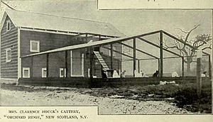
Clarence Houck's Cattery - New Scotland, NY
|
||
|
||

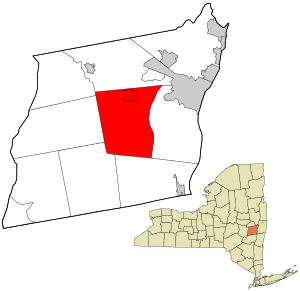
Location in Albany County and the state of New York.
|
||
| Country | United States | |
| State | New York | |
| County | Albany | |
| Incorporated | 1832 | |
| Government | ||
| • Type | Town Council | |
| Area | ||
| • Total | 57.97 sq mi (150.14 km2) | |
| • Land | 57.50 sq mi (148.92 km2) | |
| • Water | 0.47 sq mi (1.21 km2) | |
| Elevation | 666 ft (203 m) | |
| Population
(2020)
|
||
| • Total | 9,096 | |
| • Estimate
(2016)
|
8,760 | |
| Time zone | UTC-5 (Eastern (EST)) | |
| • Summer (DST) | UTC-4 (EDT) | |
| ZIP Codes |
12041 (Clarksville)
12067 (Feura Bush) 12186 (Voorheesville) 12009 (Altamont) 12054 (Delmar) 12158 (Selkirk) 12159 (Slingerlands) 12203 (Albany) |
|
| FIPS code | 36-001-50672 | |
| GNIS feature ID | 0979272 | |
New Scotland is a town located in Albany County, New York, United States. In 2020, about 9,096 people lived there.
The town is found southwest of Albany, which is the capital city of New York State. New Scotland is in the central part of Albany County.
Contents
History of New Scotland
The area that is now New Scotland was first settled around the year 1660. The town itself was officially created in 1832. It was formed from the western part of the nearby town of Bethlehem.
Some important historical places in New Scotland are recognized nationally. These include the Bennett Hill Farm, the Presbyterian Church in New Scotland and the New Scotland Cemetery, and the Onesquethaw Valley Historic District. These sites are listed on the National Register of Historic Places, which means they are important to the history of the United States.
Geography and Landscape
New Scotland covers a total area of about 58.4 square miles (151.3 square kilometers). Most of this area, about 58.1 square miles (150.5 square kilometers), is land. The remaining small part, about 0.3 square miles (0.8 square kilometers), is water.
Population Changes Over Time
The population of New Scotland has changed quite a bit over the years. Here's a look at how many people have lived in the town during different census years:
| Historical population | |||
|---|---|---|---|
| Census | Pop. | %± | |
| 1840 | 2,912 | — | |
| 1850 | 3,459 | 18.8% | |
| 1860 | 3,304 | −4.5% | |
| 1870 | 3,411 | 3.2% | |
| 1880 | 3,251 | −4.7% | |
| 1890 | 3,207 | −1.4% | |
| 1900 | 3,058 | −4.6% | |
| 1910 | 2,834 | −7.3% | |
| 1920 | 2,470 | −12.8% | |
| 1930 | 2,841 | 15.0% | |
| 1940 | 3,302 | 16.2% | |
| 1950 | 3,956 | 19.8% | |
| 1960 | 5,818 | 47.1% | |
| 1970 | 8,481 | 45.8% | |
| 1980 | 8,976 | 5.8% | |
| 1990 | 9,139 | 1.8% | |
| 2000 | 8,626 | −5.6% | |
| 2010 | 8,648 | 0.3% | |
| 2020 | 9,096 | 5.2% | |
| U.S. Decennial Census | |||
In 2000, there were 8,626 people living in New Scotland. Most of the residents were White (about 98%). A small number of people were African American, Native American, or Asian. About 0.87% of the population identified as Hispanic or Latino.
The average household in New Scotland had about 2.58 people. The average family size was about 2.98 people. About 33.7% of households had children under 18 living with them. The median age of people in the town was 41 years old.
Communities and Places in New Scotland
New Scotland is home to several smaller communities and interesting locations:
- Camp Pinnacle – This spot is in the northwestern part of the town.
- Clarksville – A small community called a hamlet. It's in the southwestern part of the town, located on Route 443.
- Feura Bush – Another hamlet found in the southeastern part of the town. It's south of Unionville.
- Meads Corner – This location is southeast of Clarksville.
- New Salem – A hamlet situated west of the main New Scotland hamlet.
- New Scotland – This is the main hamlet that shares the town's name. It is located south of Voorheesville.
- Tarrytown (also known as "Onesquethaw") – A hamlet found south of Clarksville.
- Unionville – This hamlet is near the eastern border of the town, next to Bethlehem.
- Vly Creek Reservoir – A large body of water that stores water, located south of New Salem. The Town of Bethlehem now owns it.
- Voorheesville – An official village located in the northern part of the town.
- Wolf Hill – A hamlet located right at the western edge of the town.
Town Government and Leadership
The town of New Scotland is governed by a Town Board. This board includes a Supervisor and several Councilpersons. They make decisions for the town and its residents.
- Supervisor, Douglas LaGrange, Term ends: December 31, 2025
- Councilperson, Daniel Leinung, Term ends: December 31, 2025
- Councilperson, Adam Greenberg, Term ends: December 31, 2025
- Councilperson, Bridget Burke, Term ends: December 31, 2027
- Councilperson, William Hennessy, Jr., Term ends: December 31, 2027
See also
 In Spanish: New Scotland (Nueva York) para niños
 | Selma Burke |
 | Pauline Powell Burns |
 | Frederick J. Brown |
 | Robert Blackburn |


