Newton Loch, South Ayrshire facts for kids
Quick facts for kids Newton Loch |
|
|---|---|

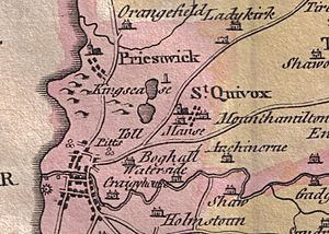
Newton Loch on William Aiton's Map of 1811
|
|
| Lua error in Module:Location_map at line 420: attempt to index field 'wikibase' (a nil value). | |
| Location | Newton-on-Ayr, South Ayrshire, Scotland |
| Type | Drained freshwater loch |
| Primary inflows | Sanquhar and Crook mosses, rainwater and surface drainage |
| Primary outflows | Half Mile and Lochside Burns |
| Catchment area | Newton and St Quivox Parish |
| Basin countries | Scotland |
| Settlements | Ayr |
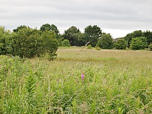
Newton Loch was a freshwater loch (a Scottish word for lake) located in a low-lying area near Newton-on-Ayr, in South Ayrshire, Scotland. Today, you can't see the loch anymore. It has been drained and now looks like open land or slightly darker areas in fields.
The water from Newton Loch used to flow into the sea at Newton-on-Ayr through a stream called the Half Mile Burn. Another stream, called a lade, carried water from the loch down the main street of Newton-on-Ayr. This lade powered a mill known as the Newton Mill or Malt Mill, which was located near the River Ayr.
Contents
The Story of Newton Loch
Newton Loch was a natural lake, formed in a dip in the land, likely created by glaciers long ago. It was shaped a bit like a map of Great Britain. The loch got its water from nearby wet areas called Sanquhar and Crook mosses, as well as from rain and water running off the land.
How the Loch's Water Flowed
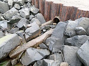
The main way water left the loch was through the Half Mile Burn. This burn now flows underground and empties into the sea through a pipe at the Newton-on-Ayr promenade.
A second way water left the loch was through a special channel called a mill lade. This lade ran along the side of Newton-on-Ayr Main Street. It carried water to power the Newton or Malt Mill, which was located close to where the 'New Bridge' of Ayr is today.
The Newton or Malt Mill
The Newton or Malt Mill was an important building in Newton-on-Ayr. It was located at the end of Main Street, right by the River Ayr. It was called the "Malt Mill" because across the river there was an old market area called the Malt Cross.
The mill lade, which brought water to the mill, was an open channel running beside the main street. This could be a problem for people and animals moving around. In 1641, the local court made a rule. It said that no one should wash dirty clothes, animal parts, or anything else in the lade. This was to keep the water clean for the mill.
The mill was still in use in 1832. Records show that people involved in the riots related to the First Reform Election used it as a shelter. This means the mill was active for a long time.
Why Newton Loch Disappeared
The land around Newton Loch was very fertile, meaning it was great for farming. Farmers wanted to use this rich land. Because of this, the loch was slowly drained over many years. Maps from different times show how the loch got smaller and smaller.
By 1747, a map by Roy shows only a small area of open water near Sanquhar Farm. The areas around it were already being farmed. A map from 1775 by Andrew Armstrong suggests that there was no open water left at all. However, a map from 1811 by William Aiton might show two small open water areas, one of which could have been Newton Loch.
Even in 1895, an Ordnance Survey map showed a tiny bit of open water and wet land still existing. This was probably the very last part of the once large Newton Loch. By 1947, it was shown as just a wet area without open water. Today, much of this area is covered by houses.
Clues in Place Names
Many local names still remind us that Newton Loch once existed. Names like Lochside, Lochside Road, Mosside, Crookmoss, Damside, and Burnside all point to the old loch and its streams. Even 'Noltmire Road' means 'boggy land where cattle graze', which fits with a drained loch area.
The three 'Sanquhar' farms in the area might even suggest something interesting. 'Sanquhar' is a Gaelic word meaning 'Old Fort'. This could hint at the presence of a crannog, which was an ancient artificial island often found in Scottish lochs. However, it might also just refer to the old Newton Castle, which was once known as Sanquhar Castle.
Coal Mining Near the Loch
The lade that carried water to the Newton or Malt Mill also brought water from a pumping station. This station was connected to a coal mine near the old loch. The ground in that area was very wet, with water close to the surface. After the loch was drained by 1775, the mill relied on water from drainage and these mining sources to operate.
Roads and Railways
Important old roads that went to Edinburgh and Glasgow passed through the area where the loch once was. Also, parts of the Glasgow and South Western Railway's 'Ayr Branch' and 'Ayr and Mauchline Branch' lines were built right across the former site of Newton Loch.
Interesting Facts
The Half Mile Burn, which flowed from the loch, was once an important boundary. It marked the official border of the town of Ayr for parliamentary purposes.
 | Laphonza Butler |
 | Daisy Bates |
 | Elizabeth Piper Ensley |


