Nganmarriyanga, Northern Territory facts for kids
Quick facts for kids NganmarriyangaNorthern Territory |
|
|---|---|
| Population | 427 (2016 census) |
| Postcode(s) | 0822 |
| Elevation | 8 m (26 ft) |
| Location | 362 km (225 mi) from Darwin |
| LGA(s) | West Daly Regional Council |
| Territory electorate(s) | Daly |
| Federal Division(s) | Lingiari |
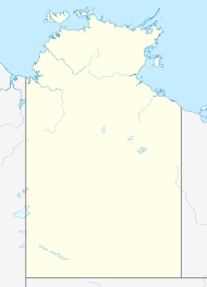
Nganmarriyanga, once known as Palumpa, is an Aboriginal community. It is located in the Daly River area of the Northern Territory, Australia.
Contents
A Look at Nganmarriyanga's Past
Nganmarriyanga started as a place called Palumpa. This name came from a nearby cattle station, which is like a big farm where cattle are raised. This station was set up after World War II to help supply food and other items to communities nearby, like Wadeye. Later, the community council asked for the name to be changed from Palumpa to Nganmarriyanga.
The Wodidj family were the first to found this community. Before World War II, they had left the area. The men went to work on cattle stations in Western Australia. After the war, they returned to a place called Port Keats Mission, which is now Wadeye.
From there, the Wodidj family moved to where Nganmarriyanga is today. They worked hard to build their new home. They cut timber, built fences, and dug ditches to bring water from creeks. They also raised cattle and sold them to people in other communities.
In the 1980s, more people moved to Palumpa. In 1985, the community formed a group called Palumpa Community Inc. This group helped manage the community and raised money to build important things like roads and buildings.
How Nganmarriyanga is Governed
Nganmarriyanga used to be part of the Victoria Daly Shire. But in 2014, it became part of a new local government area called the West Daly Region. This means the local council helps make decisions for the community.
The community also works with the Northern Land Council. This council helps Aboriginal people manage their land and waters in the Northern Territory.
Getting to Nganmarriyanga
Nganmarriyanga is about 131 kilometers (81 miles) west of the Daly River crossing. You can reach it by following the Port Keats Road.
The road is usually open for about eight months of the year, from May to December. During the wet season, which has heavy rains, the roads often flood. This makes them impossible to use. So, during these months, the only way to get to Nganmarriyanga is by plane.
In early 2023, there were very heavy rains in the area. The Victoria River flooded badly. People living in nearby places like Daguragu, Kalkarindji, Pigeon Hole, and Palumpa had to be moved to safety.
Who Lives in Nganmarriyanga?
According to the 2021 Australian census, 427 people live in Nganmarriyanga. The main language spoken by the people here is Murrinh-patha.
Daily Life and Activities
Palumpa Station is still a working cattle station. It is owned and run by the traditional owners of the land. A new place to prepare meat was built there recently. The station is a big employer, giving jobs to many local Aboriginal men.
People in Palumpa enjoy hunting for food. They hunt animals like bullock, turtle, goose, goanna, cat-fish, kangaroo, and different kinds of fish.
Nganmarriyanga Primary School is an important part of the community. It has about 130 students, from preschool up to Year 10.
There is also a community health clinic in Nganmarriyanga. It was built in 1998 and helps keep everyone in the community healthy.
 | Sharif Bey |
 | Hale Woodruff |
 | Richmond Barthé |
 | Purvis Young |


