Nikep, Maryland facts for kids
Quick facts for kids
Nikep, Maryland
|
|
|---|---|
 |
|
| Country | |
| State | |
| County | |
| Area | |
| • Total | 0.15 sq mi (0.39 km2) |
| • Land | 0.15 sq mi (0.39 km2) |
| • Water | 0.00 sq mi (0.00 km2) |
| Elevation | 1,486 ft (453 m) |
| Population
(2020)
|
|
| • Total | 95 |
| • Density | 633.33/sq mi (243.76/km2) |
| Time zone | UTC−5 (Eastern (EST)) |
| • Summer (DST) | UTC−4 (EDT) |
| FIPS code | 24-55950 |
| GNIS feature ID | 2583666 |
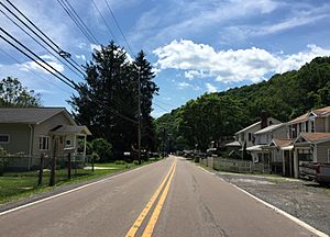
Nikep is a small community located in Allegany County, Maryland, in the United States. It is known as an "unincorporated community," which means it does not have its own local government. It is also a "census-designated place" (CDP), an area defined by the government for counting people.
About Nikep
Nikep was originally called Pekin. However, the name was changed when the first post office opened. This was because another place in Indiana already used the name Pekin. So, the community was renamed Nikep.
Where is Nikep Located?
Nikep is found in the Georges Creek Valley in the western part of Allegany County. It sits along the old path of Maryland Route 36.
- The town of Lonaconing is about 1.6 miles (2.6 km) to the northeast.
- The town of Westernport is about 6.6 miles (10.6 km) to the southwest.
Population of Nikep
The number of people living in Nikep is counted during the U.S. Census.
- In 2010, the population was 116 people.
- By 2020, the population was 95 people.
See also
 In Spanish: Nikep (Maryland) para niños
Black History Month on Kiddle
Renowned African-American Artists:
 | Kyle Baker |
 | Joseph Yoakum |
 | Laura Wheeler Waring |
 | Henry Ossawa Tanner |

All content from Kiddle encyclopedia articles (including the article images and facts) can be freely used under Attribution-ShareAlike license, unless stated otherwise. Cite this article:
Nikep, Maryland Facts for Kids. Kiddle Encyclopedia.


