Nipukatasi River facts for kids
Quick facts for kids Nipukatasi |
|
|---|---|

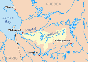
Watershed of Broadback River
|
|
| Country | Canada |
| Province | Quebec |
| Region | Eeyou Istchee Baie-James (municipality) |
| Physical characteristics | |
| Main source | Forested lake Eeyou Istchee Baie-James (municipality), Nord-du-Québec, Quebec 410 m (1,350 ft) 50°29′31″N 76°03′19″W / 50.49194°N 76.05528°W |
| River mouth | Broadback River Eeyou Istchee Baie-James (municipality), Nord-du-Québec, Quebec 252 m (827 ft) 50°43′45″N 76°12′49″W / 50.72917°N 76.21361°W |
| Length | 115.4 km (71.7 mi) |
The Nipukatasi River is a river in Quebec, Canada. It flows into the Broadback River, which then empties into Rupert Bay. Rupert Bay is a part of the larger James Bay. This river is located in the Eeyou Istchee Baie-James (municipality) area, in the Nord-du-Québec region.
Contents
Where the Nipukatasi River Flows
The Nipukatasi River is surrounded by many other waterways. Knowing these helps us understand its journey.
- To the north, you'll find the Broadback River.
- To the east, there are lakes like Amisquioumisca and Caminscanane.
- To the south, you can find Opataouaga Lake, Poncheville Lake, and the Maicasagi River.
- To the west, there are Lake Quenonisca, Lake Salamander, and Evans Lake.
The River's Beginning
The Nipukatasi River starts from a small, unnamed lake. This lake is about 0.5 kilometres (0.31 mi) long and sits at an elevation of 410 metres (1,350 ft). It's like the river's birthplace! This starting lake is near other lakes like Caminscanane and Bétulaie.
The River's Journey Downstream
From its starting lake, the Nipukatasi River begins its flow. It travels northeast, then turns west. It passes through wet, marshy areas. The river then flows into Lake Bétulaie, which is about 4.3 kilometres (2.7 mi) long. The river crosses this lake for about 3.0 kilometres (1.9 mi).
After Lake Bétulaie, the river continues its path. It flows north for a short distance before turning southwest. It moves through more marshy lands. Eventually, the river reaches Amisquioumisca Lake.
Flowing Through Amisquioumisca Lake
Amisquioumisca Lake is a very important part of the Nipukatasi River's journey. This lake is 12.5 kilometres (7.8 mi) long and is at an elevation of 302 metres (991 ft). It's the main body of water the river flows through. The river leaves this lake from its southwest side.
The Final Stretch of the River
After leaving Amisquioumisca Lake, the Nipukatasi River flows west. It then turns north, receiving water from an eastern stream. The river then changes direction again, flowing southwest.
Later, it turns north once more, heading towards Lake Rocher. Lake Rocher is at an elevation of 255 metres (837 ft). The Nipukatasi River flows for a long stretch through this area. In its last part, the river flows northeast, crossing another lake that is 6.4 kilometres (4.0 mi) long.
Finally, the Nipukatasi River joins the Broadback River. It meets the Broadback River on its south shore, just upstream from Quenonisca Lake.
What's in a Name?
The name Nipukatasi River was officially recognized on December 5, 1968. This was done by the Commission de toponymie du Québec, which is a group in Quebec that names places.
 | Roy Wilkins |
 | John Lewis |
 | Linda Carol Brown |

