Niquero facts for kids
Quick facts for kids
Niquero
|
|
|---|---|

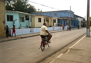
Calle Céspedes
|
|

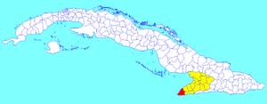
Niquero municipality (red) within
Granma Province (yellow) and Cuba |
|
| Country | Cuba |
| Province | Granma |
| Established | 1825 |
| Area | |
| • Total | 582 km2 (225 sq mi) |
| Elevation | 5 m (16 ft) |
| Population
(2022)
|
|
| • Total | 41,198 |
| • Density | 70.79/km2 (183.34/sq mi) |
| Time zone | UTC-5 (EST) |
| Area code(s) | +53-23 |
| Website | https://www.niquero.gob.cu/es/ |
Niquero is a town and a special area (called a municipality) in Cuba. It's part of the Granma Province. Guess what? Niquero is the southernmost place in the entire country! It's located right on the coast, next to the Gulf of Guacanayabo. A famous spot called Cape Cruz (or Cabo Cruz), which is the westernmost point of the province, is also found in Niquero.
Contents
History of Niquero
The Granma Yacht Landing
Niquero is famous for an important event in Cuban history. During the Cuban Revolution, a yacht named Granma landed here. This happened on December 2, 1956.
The yacht carried 82 members of the 26th of July Movement. Among them were important leaders like Fidel Castro, Raúl Castro, Che Guevara, and Camilo Cienfuegos. They had traveled all the way from Tuxpan, in Mexico.
The Granma landed near a beach called Playa Las Coloradas. This spot is just a few kilometers south of Niquero town. Today, there's a special place called the Desembarco del Granma National Park. Its name means "Landing of the Granma" National Park. It was named after this historic event.
Geography of Niquero
Where is Niquero Located?
Niquero is divided into several smaller areas called barrios. Some of these include Belic, Guanito, Jagua, La Marea, El Plátano, and Sevilla Abajo. You can also find Cabo Cruz, Hondón, Marea de Belic, Alegría de Pío, Estacadero, and La Ricardo here. As mentioned, Niquero is the southernmost municipality in all of Cuba.
Population and Size
In 2022, about 41,198 people lived in Niquero. The total area of the municipality is about 582 square kilometers (which is about 225 square miles). This means there are about 70 people living in each square kilometer.
Getting Around Niquero
Roads and Landmarks
The main road that goes through Niquero is called the "Circuito Sur de Oriente" (CSO). This is a state highway that helps people travel around the area.
At Cape Cruz, there's a very important lighthouse. It's called Faro Vargas. Lighthouses help guide ships safely along the coast.
Twin Town
Niquero has a special friendship with another town. It is "twinned" with Tuxpan in Mexico. This is the same city where the Granma yacht started its journey!
See also
 In Spanish: Niquero para niños
 | Bayard Rustin |
 | Jeannette Carter |
 | Jeremiah A. Brown |

