Nora, Illinois facts for kids
Quick facts for kids
Nora
|
|
|---|---|

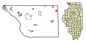
Location of Nora in Jo Daviess County, Illinois
|
|

Location of Illinois in the United States
|
|
| Country | United States |
| State | Illinois |
| County | Jo Daviess |
| Township | Nora |
| Area | |
| • Total | 0.83 sq mi (2.15 km2) |
| • Land | 0.83 sq mi (2.15 km2) |
| • Water | 0 sq mi (0 km2) |
| Elevation | 1,014 ft (309 m) |
| Population
(2020)
|
|
| • Total | 107 |
| • Density | 128.92/sq mi (49.79/km2) |
| Time zone | UTC-6 (CST) |
| • Summer (DST) | UTC-5 (CDT) |
| ZIP Code(s) |
61059
|
| Area code(s) | 815 |
| FIPS code | 17-53195 |
Nora is a small village located in Jo Daviess County, in the state of Illinois, United States. In 2020, about 107 people lived there. This number was a bit lower than in 2010, when 121 people lived in Nora.
Contents
History of Nora Village
Nora got its name from a railroad official. He named it after a woman who was one of the early settlers in the area. Another story says the name "Nora" was chosen because it was short and easy to remember, which fit the small size of the village.
For many years, Nora had its own school called Nora Elementary School. The school's sports teams were known as the Navahos. In the early 1980s, the school closed down. The building was later changed into apartments where people could live.
Before the 1960s, there was a grocery store in town run by a woman named Belle Lutter. She had a fun story about riding the horse of Ulysses S. Grant when she was a girl. Grant was a famous general and later a president of the United States.
Geography of Nora
Nora is found at specific coordinates: 42.456072 degrees North and 89.945113 degrees West. This helps us pinpoint its exact spot on a map.
According to information from 2010, the village of Nora covers a total area of about 0.91 square miles (or 2.15 square kilometers). All of this area is land; there are no large bodies of water within the village limits.
Population Changes Over Time
The number of people living in Nora has changed quite a bit over the years. Here's a look at how the population has grown and shrunk:
| Historical population | |||
|---|---|---|---|
| Census | Pop. | %± | |
| 1880 | 333 | — | |
| 1890 | 309 | −7.2% | |
| 1900 | 312 | 1.0% | |
| 1910 | 251 | −19.6% | |
| 1920 | 213 | −15.1% | |
| 1930 | 180 | −15.5% | |
| 1940 | 207 | 15.0% | |
| 1950 | 208 | 0.5% | |
| 1960 | 229 | 10.1% | |
| 1970 | 175 | −23.6% | |
| 1980 | 185 | 5.7% | |
| 1990 | 162 | −12.4% | |
| 2000 | 118 | −27.2% | |
| 2010 | 121 | 2.5% | |
| 2020 | 107 | −11.6% | |
| U.S. Decennial Census | |||
In the year 2000, there were 118 people living in Nora. These people lived in 53 different homes, and 31 of these were families. The village had about 130 people per square mile.
- About 20% of the homes had children under 18 living there.
- More than half of the homes (50.9%) were married couples living together.
- About 40% of all homes were made up of single individuals.
- Nearly a quarter of homes (24.5%) had someone living alone who was 65 years old or older.
The average number of people in each home was about 2.23. For families, the average was about 2.84 people.
Education in Nora
Students in Nora attend schools that are part of the Warren Community Unit School District 205. This school district helps make sure that children in Nora and nearby areas get a good education.
See also
 In Spanish: Nora (Illinois) para niños
 | Kyle Baker |
 | Joseph Yoakum |
 | Laura Wheeler Waring |
 | Henry Ossawa Tanner |

