North Eaton River facts for kids
Quick facts for kids North Eaton River |
|
|---|---|

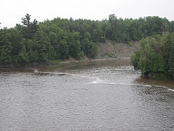
North Eaton River near the New Mexico Road Bridge.
|
|
| Native name | Rivière Eaton Nord |
| Country | Canada |
| Province | Quebec |
| Region | Estrie |
| MRC | Le Haut-Saint-François Regional County Municipality |
| Municipality | La Patrie, Newport et de Cookshire-Eaton |
| Physical characteristics | |
| Main source | Newport 490 m (1,610 ft) 45°22′57″N 71°18′22″W / 45.382375°N 71.306238°W |
| River mouth | Saint-François River Cookshire-Eaton 208 m (682 ft) 45°23′55″N 71°35′12″W / 45.39861°N 71.58666°W |
| Length | 37.5 km (23.3 mi) |
| Basin features | |
| Progression | Saint-François River, Saint Lawrence River |
| Tributaries |
|
The North Eaton River (which is Rivière Eaton Nord in French) is a river in Quebec, Canada. It's a smaller river that flows into the Eaton River. The Eaton River then joins the Saint-François River, and finally, the Saint-François River flows into the mighty Saint Lawrence River.
This river travels through a few towns and areas. These include La Patrie, Newport, and Cookshire-Eaton. All these places are part of the Le Haut-Saint-François Regional County Municipality (often called an MRC), which is in the Estrie region of Quebec.
Contents
About the North Eaton River
The North Eaton River is about 37.5 km (23.3 mi) long. It starts high up on Mount West Ditton and flows generally towards the northwest. This river is an important part of the local water system.
Where the River Begins
The North Eaton River starts in the town of La Patrie. Its source is on the southern side of Mount West Ditton, which is a mountain with a top at 542 m (1,778 ft) high. This starting point is southwest of the village of La Patrie. It's also west of another river called the Rivière au Saumon.
The River's Journey
From its source, the North Eaton River flows for about 37.5 km (23.3 mi). It travels through different areas and picks up water from smaller streams along the way.
Here's how its journey goes:
- It flows for about 4.1 km (2.5 mi) to the southeast in the Township of Eaton.
- Then, it turns west for about 8.3 km (5.2 mi). Here, another river called the "South River" joins it from the south. This happens in the Township of Newport.
- Next, it flows northwest for 1.8 km (1.1 mi), where Ditton West brook adds its water.
- It continues west for 3.0 km (1.9 mi) until the Ruisseau au Pin joins it from the north.
- The river then flows west for 6.4 km (4.0 mi), passing under a road bridge near the hamlet of New Mexico.
- After that, it goes northwest for 3.0 km (1.9 mi) and meets Island Creek.
- It travels west for 5.5 km (3.4 mi) to another road bridge.
- Finally, it flows northwest for 5.4 km (3.4 mi) until it reaches its end.
The North Eaton River eventually empties into the Eaton River. This meeting point is about 1.2 km (0.75 mi) downstream from the Lakes Mill Bridge. It's also 1.4 km (0.87 mi) upstream from the bridge on Route 212.
Surrounding Waterways
Many other rivers and streams are close to the North Eaton River. These are called "hydrographic slopes" because they are areas where water drains into a particular river system.
- North side: Newport River (North Eaton River), Pope Creek, Saint-François River, Ditton West Creek.
- East side: Ditton River, rivière aux Saumons (Massawippi River tributary).
- South side: Lyon stream, Eaton River, rivière du Sud (North Eaton River).
- West side: Eaton River.
Naming the River
The name "Rivière Eaton Nord" (North Eaton River) became official on December 5, 1968. This was decided by the Commission de toponymie du Québec, which is a group in Quebec that makes sure place names are correct and official.
 | Valerie Thomas |
 | Frederick McKinley Jones |
 | George Edward Alcorn Jr. |
 | Thomas Mensah |


