North Fork Koyukuk River facts for kids
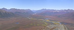
The North Fork of the Koyukuk River is a major branch of the Koyukuk River in northern Alaska, United States. It flows for about 105 miles (160 kilometers). This river is special because it runs through the beautiful Gates of the Arctic National Park and Preserve.
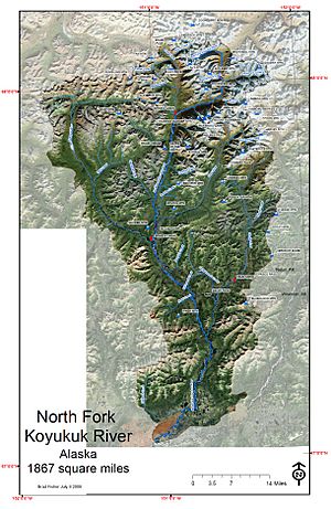
The river's water comes from the southern slopes of the Brooks Range. This mountain range is part of the Continental Divide, which separates river systems. The North Fork Koyukuk River's watershed covers an area of about 1,850 square miles (4,791 square kilometers).
Contents
Exploring the North Fork Koyukuk River
The North Fork of the Koyukuk River is a very important part of the Gates of the Arctic National Park and Preserve. This park is a huge, wild area in Alaska. It protects the natural beauty and wildlife of the region.
A Wild and Scenic River
In 1980, the United States Congress officially named the North Fork Koyukuk River a "Wild and Scenic River." This special title helps protect the river and its surroundings. It means the river's natural state is preserved for future generations.
River Branches and Connections
The North Fork Koyukuk River has several smaller rivers that flow into it. These are called tributaries. Important tributaries include the Glacier River, Tinayguk River, and Clear River. Eventually, the North Fork joins with the Middle Fork Koyukuk River. Together, they form the main part, or "main stem," of the larger Koyukuk River.
Discovering the Gates of the Arctic
A famous explorer named Robert Marshall explored this river system in 1929. He spent a lot of time mapping and learning about the area. Marshall gave names to many of the tall mountains you can see there.
He named peaks like Mount Doonerak, Frigid Crags, and Boreal Mountain. The mountains Frigid Crags and Boreal Mountain are especially famous. They form what Marshall called the "Gates of the Arctic." This name describes how these two mountains stand like giant gates to the Arctic wilderness.
 | Misty Copeland |
 | Raven Wilkinson |
 | Debra Austin |
 | Aesha Ash |


