North Pownal, Vermont facts for kids
Quick facts for kids
North Pownal, Vermont
|
|
|---|---|

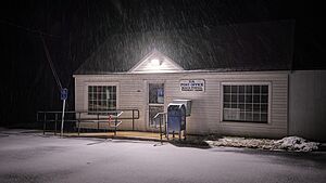
Post office
|
|
| Country | United States |
| State | Vermont |
| County | Bennington |
| Town | Pownal |
| Area | |
| • Total | 1.21 sq mi (3.14 km2) |
| • Land | 1.19 sq mi (3.08 km2) |
| • Water | 0.02 sq mi (0.05 km2) |
| Elevation | 510 ft (160 m) |
| Time zone | UTC-5 (Eastern (EST)) |
| • Summer (DST) | UTC-4 (EDT) |
| ZIP Code |
05260
|
| Area code(s) | 802 |
| FIPS code | 50-51325 |
| GNIS feature ID | 2807123 |
North Pownal is a small community in the state of Vermont, United States. It's not a full town but an "unincorporated community." This means it's a group of homes and businesses without its own local government, but it's part of a larger town called Pownal.
It's also known as a "census-designated place" (CDP). This is a special area that the U.S. Census Bureau defines for counting people. North Pownal was first listed as a CDP before the 2020 census.
Discover North Pownal, Vermont
North Pownal is a quiet spot located in the southwestern part of Bennington County. It sits in the western section of the town of Pownal.
Where is North Pownal Located?
This community is quite close to the border between Vermont and New York. It's only about 1 mile (1.6 km) east of the state line.
A river called the Hoosic River flows right through the middle of North Pownal. This river travels west and eventually joins the Hudson River.
Getting Around North Pownal
The main road that goes through North Pownal is Vermont Route 346. If you travel southeast on this road for about 3 miles (4.8 km), you'll reach U.S. Route 7 and the main Pownal village.
If you head northwest on the same road, which becomes NY 346 once you cross into New York, you'll reach North Petersburg, New York in about 4 miles (6.4 km).
 | Anna J. Cooper |
 | Mary McLeod Bethune |
 | Lillie Mae Bradford |


