
Nullarbor Plain facts for kids
The Nullarbor Plain is a huge, flat, and very dry area of land in southern Australia. It stretches along the coast of the Great Australian Bight. The name "Nullarbor" comes from Latin words meaning "no trees." This plain is the world's largest single piece of limestone. It covers about 200,000 square kilometers (about 77,000 square miles). At its widest point, it is about 1,100 kilometers (about 680 miles) from east to west. It lies between South Australia (SA) and Western Australia (WA).


Contents
What is the Nullarbor Plain?
The Nullarbor Plain is a vast, flat area. It is mostly made of limestone, which is a type of rock formed from the shells and skeletons of tiny sea creatures. Millions of years ago, this area was covered by the ocean. When the ocean dried up, it left behind this huge limestone plain.
Why is it called "Nullarbor"?
The name "Nullarbor" comes from two Latin words: nullus, which means "no," and arbor, which means "tree." So, Nullarbor literally means "no trees." This name perfectly describes the plain because it has very few trees. Instead, you'll mostly see low-growing shrubs and grasses.
Where is the Nullarbor Plain located?
The Nullarbor Plain is located in southern Australia. It stretches across two states: South Australia and Western Australia. It follows the coastline of the Great Australian Bight, which is a large bay off the southern coast of Australia.
How big is the Nullarbor Plain?
This flat land is incredibly large. It covers an area of about 200,000 square kilometers (77,000 square miles). To give you an idea, that's bigger than many countries! From east to west, it stretches about 1,100 kilometers (680 miles). This makes it one of the largest flat areas on Earth.
Unique Features of the Nullarbor
Even though it's flat and dry, the Nullarbor Plain has some interesting features.
Caves and Sinkholes
Because the plain is made of limestone, it has many underground caves and sinkholes. These are formed over thousands of years as rainwater seeps through the rock, dissolving it. Some of these caves are very deep and long. The Murrawijinie cave system, for example, is a karst system. This means it's a landscape shaped by the dissolving of soluble bedrock, like limestone.
Indigenous History in the Caves
The Murrawijinie caves also have a special history. The name "Murrawijinie" means "bloody hands." This is because Indigenous people used these caves long ago. They left behind ochre hand stencils on the cave walls. These stencils are like ancient paintings, showing where people lived and what they did.
The Eyre Highway
The Eyre Highway is a famous road that crosses the Nullarbor Plain. It's known for having the longest straight stretch of road in Australia, about 146.6 kilometers (90 miles) long, with no turns! Driving across the Nullarbor is a unique experience because the landscape is so vast and open.
Images for kids
-
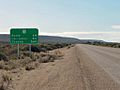
A road sign displaying the distance from Eucla and Ceduna
-
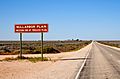
Sign defining the edge of the plain at the western side. (This photograph depicts Nullarbor Roadhouse, seen from the west. Nullarbor Roadhouse lies on the South Australian side of the Eyre Highway, at the eastern edge of the Nullarbor Plain as well as Nullarbor National Park, which both extend miles farther west into Western Australian territory.)
-
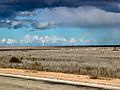
Rainbow over the Nullarbor Plain
-
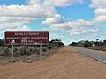
Vandalised road sign designating the beginning of the 90-mile (or 146.6 km) straight section of the highway
-
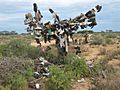
Tree full of shoes in "the middle of nowhere", the Nullarbor, Western Australia
-
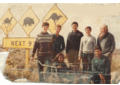
The group that walked from Port Augusta to Norseman, including the Nullarbor Plain, in 1985

.jpg)


See also
 In Spanish: Llanura de Nullarbor para niños
