
Oak Hills, Oregon facts for kids
Quick facts for kids
Oak Hills, Oregon
|
|
|---|---|
|
Census-designated place (CDP)
|
|

Entrance to the development
|
|

Location of Oak Hills, Oregon
|
|
| Country | United States |
| State | Oregon |
| County | Washington |
| Established | 1965 |
| Area | |
| • Total | 1.56 sq mi (4.03 km2) |
| • Land | 1.56 sq mi (4.03 km2) |
| • Water | 0.00 sq mi (0.00 km2) |
| Elevation | 249 ft (76 m) |
| Population
(2020)
|
|
| • Total | 11,903 |
| • Density | 7,644.83/sq mi (2,950.99/km2) |
| Time zone | UTC-8 (Pacific (PST)) |
| • Summer (DST) | UTC-7 (PDT) |
| ZIP code |
97006
|
| Area code(s) | 503 and 971 |
| FIPS code | 41-53988 |
| GNIS feature ID | 2408963 |
|
Oak Hills Historic District
|
|

District sign
|
|

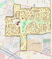
The Oak Hills Historic District boundaries (black line), and historic contributing resources in the district (brown).
|
|
| Location | Roughly bounded by NW West Union & Cornell Roads, NW 143rd Ave., and Bethany Blvd. Washington County, Oregon |
| Area | 240 acres (97 ha) |
| Architect | Multiple |
| NRHP reference No. | 13000482 |
| Added to NRHP | July 10, 2013 |
Oak Hills is a special area in Washington County, Oregon, United States. It is called a census-designated place (CDP). This means it's a place where many people live, but it's not officially a city or town.
In 2020, about 11,903 people lived in the Oak Hills CDP. It is located on land that is not part of any city. This land is north of Beaverton, west of Cedar Mill, and south of Bethany. The area is bordered by the Sunset Highway to the south and West Union Road to the north.
The U.S. Postal Service uses Beaverton addresses for homes in Oak Hills. Fire and emergency services are provided by Tualatin Valley Fire and Rescue.
The Oak Hills neighborhood is a bit smaller than the CDP. It is a planned community that was built in the 1960s. A planned community is an area designed and built all at once. The first homes were finished in May 1965. There were about 650 homes planned for an area of about 250 acres. Today, Oak Hills has around 650 homes, mostly single-family houses. The neighborhood is managed by the Oak Hills Homeowners Association (OHHA). This group helps keep the community running smoothly.
In 2013, the neighborhood was added to the National Register of Historic Places. This means it is recognized as an important historical area. It is known as the Oak Hills Historic District.

Contents
Geography and Location
Oak Hills covers an area of about 1.5 square miles (4.03 square kilometers). All of this area is land. It does not include any large bodies of water.
People Living in Oak Hills
| Historical population | |||
|---|---|---|---|
| Census | Pop. | %± | |
| 2020 | 11,903 | — | |
| U.S. Decennial Census | |||
Let's look at the people who live in Oak Hills.
Population Numbers
In 2000, there were 9,050 people living in the CDP. These people lived in 3,397 households. A household can be a family or a group of people living together.
Diversity in Oak Hills
The people in Oak Hills come from many different backgrounds. In 2000, most residents were White (about 78%). There were also many people of Asian descent (about 13.7%). Other groups included African American, Native American, and Pacific Islander residents. About 5.8% of the population was Hispanic or Latino.
Age Groups
The population in Oak Hills includes people of all ages. In 2000:
- About 29% of residents were under 18 years old.
- About 9% were between 18 and 24 years old.
- About 34.5% were between 25 and 44 years old.
- About 21.6% were between 45 and 64 years old.
- About 6% were 65 years old or older.
The average age of people in Oak Hills was 32 years.
Household Income
In 2000, the average income for a household in Oak Hills was about $61,217 per year. For families, the average income was about $71,849 per year.
Images for kids
-

District sign
-
The Oak Hills Historic District boundaries (black line), and historic contributing resources in the district (brown).
See also
 In Spanish: Oak Hills (Oregón) para niños
