Ocotepeque Department facts for kids
Quick facts for kids
Ocotepeque Department
Departamento de Ocotepeque
|
|||
|---|---|---|---|
|
department
|
|||
|
|||

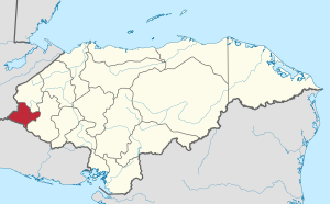
Location of Ocotepeque in Honduras
|
|||
| Country | |||
| Municipalities | 16 | ||
| Villages | 126 | ||
| Founded | 17 February 1906 | ||
| Capital city | Nueva Ocotepeque | ||
| Government | |||
| • Type | Departmental | ||
| Area | |||
| • Total | 1,636 km2 (632 sq mi) | ||
| Population
(2015)
|
|||
| • Total | 151,516 | ||
| • Density | 92.614/km2 (239.87/sq mi) | ||
| Time zone | UTC-6 (CDT) | ||
| Postal code |
43101, 43201
|
||
| ISO 3166 code | HN-OC | ||
| HDI (2017) | 0.571 medium · 11th |
||
| Statistics derived from Consult INE online database: Population and Housing Census 2013 | |||
Ocotepeque is one of the 18 departments (like states or provinces) in Honduras, a country in Central America. It is located in the western part of Honduras. This department shares its borders with two other countries: El Salvador and Guatemala.
Ocotepeque was created on February 17, 1906. It was formed from a part of the Copán department. The main city and capital of Ocotepeque is Nueva Ocotepeque.
Quick Facts About Ocotepeque
Ocotepeque covers an area of about 1,630 square kilometers (about 629 square miles). That's a bit smaller than the state of Rhode Island in the USA!
In 2015, about 151,516 people lived in the department. This makes it one of the smaller departments in Honduras by population.
Cities and Towns: The Municipalities
Like other departments in Honduras, Ocotepeque is divided into smaller areas called municipalities. These are like counties or local government areas. There are 16 municipalities in Ocotepeque.
Here are the municipalities in Ocotepeque:
- Belén Gualcho
- Concepción
- Dolores Merendon
- Fraternidad
- La Encarnación
- La Labor
- Lucerna
- Mercedes
- Ocotepeque
- San Fernando
- San Francisco del Valle
- Santa Ifigenia
- San Jorge
- San Marcos
- Santa Fé
- Sensenti
- Sinuapa
See also
 In Spanish: Departamento de Ocotepeque para niños
 | Isaac Myers |
 | D. Hamilton Jackson |
 | A. Philip Randolph |


