Officer Creek facts for kids
Quick facts for kids Officer |
|
|---|---|

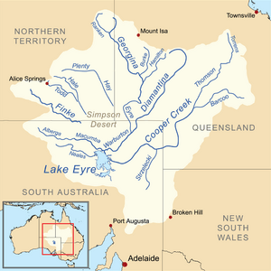
Map of the Lake Eyre Basin showing Warburton River
|
|
| Country | Australia |
| State | South Australia |
| Region | Far North |
| Settlement | Kaltjiti |
| Physical characteristics | |
| Main source | Musgrave Ranges 619 m (2,031 ft) |
| River mouth | Warburton River 388 m (1,273 ft) 27°40′S 132°19′E / 27.667°S 132.317°E |
| Length | 200 km (120 mi) |
| Basin features | |
| River system | Lake Eyre Basin |
| Tributaries |
|
The Officer Creek is a special kind of river in South Australia. It's part of the huge Lake Eyre basin. This creek is called ephemeral, which means it only flows with water after very heavy rainfall. Most of the time, it's just a dry, sandy riverbed.
Officer Creek starts in the Musgrave Ranges. It then flows through a community called Kaltjiti. This area is part of the Anangu Pitjantjatjara Yankunytjatjara Lands, which are important lands for Aboriginal people. Officer Creek eventually joins other creeks, like Ammaroodinna and Currie Creeks, and they all flow into the Warburton River.
History of Officer Creek
How the Creek Got Its Name
Officer Creek has an interesting history behind its name. In September 1873, an explorer named Ernest Giles was on his second trip into the Australian interior. He was exploring the area with another team member, William Tietkens.
Giles decided to name the river "The Officer." He did this to honor one of the people who helped fund his expedition. The name "The Officer" was used until the 1930s. After that, it became known as Officer Creek, which is what we call it today.
 | Claudette Colvin |
 | Myrlie Evers-Williams |
 | Alberta Odell Jones |

