Old Jamestown, Missouri facts for kids
Quick facts for kids
Old Jamestown, Missouri
|
|
|---|---|

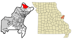
Location of Old Jamestown, Missouri
|
|
| Country | United States |
| State | Missouri |
| County | St. Louis |
| Area | |
| • Total | 14.96 sq mi (38.73 km2) |
| • Land | 14.95 sq mi (38.71 km2) |
| • Water | 0.01 sq mi (0.02 km2) |
| Elevation | 538 ft (164 m) |
| Population
(2020)
|
|
| • Total | 19,790 |
| • Density | 1,324.10/sq mi (511.23/km2) |
| Time zone | UTC-6 (Central (CST)) |
| • Summer (DST) | UTC-5 (CDT) |
| Area code(s) | 314 |
| FIPS code | 29-54352 |
| GNIS feature ID | 2583784 |
| Website | http://www.oldjamestownassn.org |
Old Jamestown is a special kind of community in St. Louis County, Missouri, United States. It's called an unincorporated community, which means it doesn't have its own local government like a city does. It's also a census-designated place (CDP), which is an area the government uses for counting people.
In 2010, about 19,184 people lived there. Old Jamestown is located to the northwest of the big city of St. Louis. It's also right next to the famous Missouri River.
Contents
Exploring Old Jamestown's Location
Old Jamestown covers an area of about 38.7 square kilometers (about 14.96 square miles). Most of this area is land, with only a tiny bit (0.06%) being water.
Where is Old Jamestown Located?
This community is mainly found north and west of U.S. Route 67. This is a major road in northern St. Louis County.
Neighboring Communities
Old Jamestown has several neighbors:
- To the north, across the Missouri River, is West Alton.
- To the southwest, you'll find Florissant.
- To the south are Black Jack and Spanish Lake.
Old Jamestown is about 17 miles (27 kilometers) north of downtown St. Louis.
People of Old Jamestown
Demographics is the study of populations. It helps us understand how many people live in a place and what they are like.
Population Changes Over Time
The number of people living in Old Jamestown has changed over the years.
- In 2010, the population was 19,184 people.
- By 2020, the population grew to 19,790 people.
This information comes from the official U.S. Decennial Census, which counts everyone in the United States every ten years.
| Historical population | |||
|---|---|---|---|
| Census | Pop. | %± | |
| 2010 | 19,184 | — | |
| 2020 | 19,790 | 3.2% | |
| U.S. Decennial Census | |||
See also
- Old Jamestown (Misuri) para niños (This link is to a Spanish article about Old Jamestown for kids.)
 | Emma Amos |
 | Edward Mitchell Bannister |
 | Larry D. Alexander |
 | Ernie Barnes |

